
Bansalan, municipality of the Philippines in the province of Davao del Sur
Location: Davao del Sur
Inception: September 18, 1952
Elevation above the sea: 167 m
Shares border with: Makilala
GPS coordinates: 6.78333,125.21667
Latest update: March 8, 2025 13:45
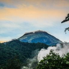
Mount Apo
23.5 km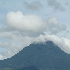
Mount Matutum
49.6 km
San Pedro Cathedral
53.5 km
Monfort Bat Sanctuary
67.5 km
Fort Pikit
67.1 km
Epol Falls
74.7 km
Davao River Bridge
55 km
Mount Apo Natural Park
24.1 km
Secdea Beach Resort Reception Area
71.4 km
D' Bone Collector Museum
53.6 km
Museo Dabawenyo
51.5 km
Pacman Beach Resort Complex
98.1 km
Fuerte de Reina Regente
82.2 km
Tagum Cathedral
97.5 km
Burial Site of the Seventeen Filipino Martyrs of Koronadal historical marker
52.3 km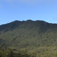
Mount Hamiguitan
106.8 km
Mount Parker
82.8 km
Davao City Hall historical marker
53.4 km
Gen. Paulino Santos historical marker
74.9 km
Tagum Historical & Cultural Center
98.4 km
Andres Bonifacio historical marker
40.6 km
Davao Museum of History and Ethnography
59.6 km
Ohta Kyozaburo historical marker
46.7 km
Museyo Kutawato
41.3 km
KCC Cinema
51.2 km
Koronadal Cathedral
52.2 km
Port Sta. Ana historical marker
55.7 km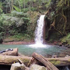
Balnunto Falls
25.1 kmReviews
Visited this place? Tap the stars to rate it and share your experience / photos with the community! Try now! You can cancel it anytime.
Discover hidden gems everywhere you go!
From secret cafés to breathtaking viewpoints, skip the crowded tourist spots and find places that match your style. Our app makes it easy with voice search, smart filtering, route optimization, and insider tips from travelers worldwide. Download now for the complete mobile experience.

A unique approach to discovering new places❞
— Le Figaro
All the places worth exploring❞
— France Info
A tailor-made excursion in just a few clicks❞
— 20 Minutes