Masungi Georeserve, Protected conservation area in Baras, Philippines
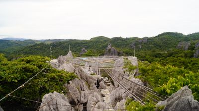
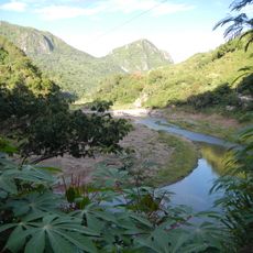
Masungi Georeserve is a protected conservation area in the southern Sierra Madre range, featuring limestone peaks and montane rainforest. The land rises to about 640 meters elevation and displays varied rock formations shaped by natural geological processes.
The area was recognized as part of a watershed reservation in 1904 and later converted into an active conservation project in 1996 to protect the geological formations. This transition reflects a shift from administrative designation to hands-on preservation efforts.
The name Masungi comes from a local word referring to the pointed limestone formations that shape the landscape. You notice this meaning directly as you walk through the area and see these distinctive peaks surrounding you.
Visits take place through guided tours featuring suspended bridges, platforms, and rope courses, with each trek lasting about three to four hours. Wear sturdy footwear and bring enough water, as the terrain is uneven and hilly throughout.
The reserve is home to the only known population of Hypselostoma latispira masungiensis, a tiny microsnail species discovered on the limestone formations in 2017. This species exists nowhere else, making the site crucial for its survival.
Inception: 1996
GPS coordinates: 14.60500,121.33861
Latest update: December 8, 2025 19:52
Angono Petroglyphs
18.2 km
Antipolo Cathedral
17.5 km
Hinulugang Taktak
18.5 km
Wawa Dam
20.9 km
Upper Marikina River Basin Protected Landscape
15.3 km
Morong Church
11.9 km
Bosay Resort
18.8 km
Morong High School
14.8 km
Antipolo Star Resort
15.9 km
Lokal ng Padilla
16.5 km
Licerio L. Geronimo historical marker
20.7 km
Church of Old Bosoboso historical marker
11.5 km
Juan M. Sumulong historical marker
17.6 km
Our Lady of Peace and Good Voyage historical marker
17.6 km
Morong historical marker
14.9 km
Casa Santa Museum
17.3 km
Church of Baras historical marker
11.9 km
Tomas Claudio historical marker
14.9 km
Church of Santa Maria historical marker
17.5 km
Church of Antipolo historical marker
17.6 km
Jose Rizal historical marker
18.4 km
Pililla Church historical marker
14.3 km
Town of Tanay historical marker
13.2 km
Church of Tanay historical marker
13.2 km
Church of Morong historical marker
14.8 km
Vicente Manasala House historical marker
20.9 km
Rizal Provincial Capitol
18.4 km
Commandancia
14.9 kmVisited this place? Tap the stars to rate it and share your experience / photos with the community! Try now! You can cancel it anytime.
Discover hidden gems everywhere you go!
From secret cafés to breathtaking viewpoints, skip the crowded tourist spots and find places that match your style. Our app makes it easy with voice search, smart filtering, route optimization, and insider tips from travelers worldwide. Download now for the complete mobile experience.
A unique approach to discovering new places❞
— Le Figaro
All the places worth exploring❞
— France Info
A tailor-made excursion in just a few clicks❞
— 20 Minutes