Chest opened
+${chestReward.xp} XP
Explorer
NOUVEAU ×${chestReward.collectible.quantity}
tapez pour fermer
Chest locked

Open chests in the app

Around Us is built for your phone — chests unlock when you walk, explore and capture nearby places.

Enable Location

We need your location to show you interesting places around you

Discover nearby places

Find interesting locations and hidden gems around you

Precise directions

Get accurate directions and distances to places

Your location is never shared with other users. It's only used when you tap the location button.

Buner District

Log in to your account

Start exploring — it's free

Trusted by 72,878 travelers worldwide

Continue with Google
Continue with Apple
or

We will send you a code to connect

By continuing, you accept our Terms and Conditions and our Privacy Policy

Check your inbox

We've sent a pincode in your inbox. Please enter the code below.

Discussion Reviews 1 Photos
25.6k Popularity

Buner District, Administrative division in Khyber Pakhtunkhwa, Pakistan

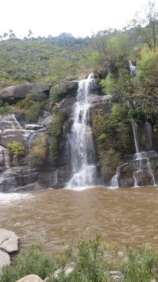
Buner District is an administrative division in Khyber Pakhtunkhwa that spans valleys and hillsides with elevations ranging between 1200 feet and 9550 feet. Pine forests and mountain vegetation cover much of the terrain, creating the natural landscape visitors encounter throughout the area.

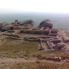
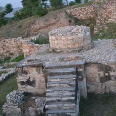
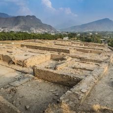
In 1586, Yusufzai forces under Kalu Khan defeated a Mughal military contingent of about 8000 soldiers near Karakar Pass during a rebellion against Emperor Akbar. This victory represents a significant moment in the region's local resistance history.

The local population speaks Pashto as their main language and continues with traditional music, handicrafts, and social customs rooted in Pashtun heritage. These cultural practices shape the daily rhythm and character of communities throughout the region.

The district is marked by active marble quarrying and processing operations spread across the area, which shape the working landscape. Visitors should be aware that industrial activity and transport movement are visible in many parts of the region throughout the day.

Three main rivers - Barandu, Chamla, and Budal - flow through the district, with the Barandu passing directly through its center and feeding agricultural lands. These waterways are vital to the farming communities and settlements scattered across the hilly landscape.

The community of curious travelers

AroundUs brings together thousands of curated places, local tips, and hidden gems, enriched daily by 60,000 contributors worldwide.

Start exploring
Inception
1991
Capital city
Daggar
Shares border with
Swabi, Mardan District, Malakand District, Swat District, Shangla District, Torghar District, Haripur District
Address
Buner, Pakistan
GPS coordinates
34.51140,72.48390
Latest update
December 14, 2025 13:23
Reviews
Share your experience

No review yet

Discussions
Start a discussion...

No discussion yet

« Buner District - Administrative division in Khyber Pakhtunkhwa, Pakistan » is provided by Around Us (aroundus.com). Images and texts are derived from Wikimedia project under a Creative Commons license. You are allowed to copy, distribute, and modify copies of this page, under the conditions set by the license, as long as this note is clearly visible.

Discover hidden gems everywhere you go!

From secret cafés to breathtaking viewpoints, skip the crowded tourist spots and find places that match your style. Our app makes it easy with voice search, smart filtering, route optimization, and insider tips from travelers worldwide. Download now for the complete mobile experience.

Around Us App Screenshot

A unique approach to discovering new places

Le Figaro

All the places worth exploring

France Info

A tailor-made excursion in just a few clicks

20 Minutes

Around Us
Travel Guide & Maps
Download

Send to your phone

QR Code
1

Open the camera app on your mobile.

2

Point at the QR code with your camera. A notification will appear.

3

Tap the notification to open the link.