Gmina Przygodzice

Log in to your account

AroundUs is a community-driven map of interesting places, built by curious explorers like you. It grows with every review, story, and photo you share.
Connect to save your favorite spots, contribute locations, and create personalized routes.
Continue with Google
Continue with Apple
Continue with X
Continue with Facebook
Continue with email
By continuing, you accept our Terms and Conditions and our Privacy Policy
Create an account
Add to collection
Map
Suggest a change
Share

Gmina Przygodzice, Rural administrative district in Ostrów Wielkopolski County, Poland.

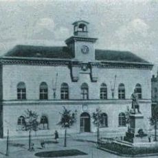
Gmina Przygodzice is a rural administrative district in Ostrów Wielkopolski County comprising multiple small villages scattered across agricultural land. The main village of Przygodzice serves as the administrative center where local offices manage services for the surrounding settlements.

The current administrative structure of this rural district was established during Poland's major governmental reorganization in 1999, which reshaped local governance. This transformation was part of a nationwide effort to redefine how local municipalities interact with regional authorities.

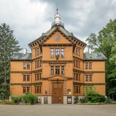
The district maintains traditional rural characteristics through its sixteen villages, including Antonin, Czarnylas, and Przygodzice, each preserving local customs and community practices.

This area presents a typical rural landscape with fields, small villages, and local roads connecting the various settlements. It is best explored at a leisurely pace, whether by car or bicycle, to experience the agricultural character of the region.

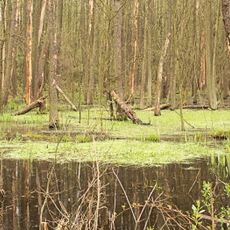
Portions of this district lie within Barycz Valley Landscape Park, a protected area where conservation efforts blend with local rural activities. This location means visitors encounter a landscape where farming practices and natural protection coexist.

Location: Ostrów Wielkopolski County

Capital city: Przygodzice

Shares border with: Gmina Mikstat, Gmina Odolanów, Gmina Ostrów Wielkopolski, Ostrów Wielkopolski, Gmina Ostrzeszów, Gmina Sieroszewice, Gmina Sośnie

Website: http://przygodzice.pl

GPS coordinates: 51.58333,17.83333

Latest update: December 11, 2025 11:01

Photos
Around this place
Palace in Antonin
Poland

Palace in Antonin

7.5 km
Konkatedra w Ostrowie Wielkopolskim
Poland

Konkatedra w Ostrowie Wielkopolskim

7.3 km
Nature reserve Wydymacz
Poland

Nature reserve Wydymacz

6.9 km
Ostrów Wielkopolski Town Hall
Poland

Ostrów Wielkopolski Town Hall

7.5 km
Muzeum Miasta Ostrowa Wielkopolskiego
Poland

Muzeum Miasta Ostrowa Wielkopolskiego

7.4 km
Exaltation of the Holy Cross church in Wysocko Wielkie
Poland

Exaltation of the Holy Cross church in Wysocko Wielkie

4.6 km
Our Lady of Perpetual Help church in Przygodzice
Poland

Our Lady of Perpetual Help church in Przygodzice

794 m
Kościół Najświętszej Maryi Panny Nieustającej Pomocy w Przygodzicach
Poland

Kościół Najświętszej Maryi Panny Nieustającej Pomocy w Przygodzicach

793 m
48 Wrocławska Street in Ostrów Wielkopolski
Poland

48 Wrocławska Street in Ostrów Wielkopolski

7.1 km
20 Gimnazjalna Street in Ostrów Wielkopolski
Poland

20 Gimnazjalna Street in Ostrów Wielkopolski

7.2 km
13-13a Zamenhofa Street in Ostrów Wielkopolski
Poland

13-13a Zamenhofa Street in Ostrów Wielkopolski

7.1 km
51 Wrocławska Street in Ostrów Wielkopolski
Poland

51 Wrocławska Street in Ostrów Wielkopolski

6.8 km
63 Kaliska Street in Ostrów Wielkopolski
Poland

63 Kaliska Street in Ostrów Wielkopolski

7.5 km
Ogród przy konwikcie arcybiskupim
Poland

Ogród przy konwikcie arcybiskupim

7.2 km
9 Kościelna Street in Ostrów Wielkopolski
Poland

9 Kościelna Street in Ostrów Wielkopolski

7.4 km
8 Partyzancka Street in Ostrów Wielkopolski
Poland

8 Partyzancka Street in Ostrów Wielkopolski

7.5 km
32 Partyzancka Street in Ostrów Wielkopolski
Poland

32 Partyzancka Street in Ostrów Wielkopolski

7.2 km
Hotel Polonia in Ostrów Wielkopolski
Poland

Hotel Polonia in Ostrów Wielkopolski

7.5 km
7 Sienkiewicza Street in Ostrów Wielkopolski
Poland

7 Sienkiewicza Street in Ostrów Wielkopolski

7.4 km
19 Kolejowa Street in Ostrów Wielkopolski
Poland

19 Kolejowa Street in Ostrów Wielkopolski

7.4 km
5 Kościuszki Street in Ostrów Wielkopolski
Poland

5 Kościuszki Street in Ostrów Wielkopolski

6.9 km
Main post office in Ostrów Wielkopolski
Poland

Main post office in Ostrów Wielkopolski

7.4 km
36 Kaliska Street in Ostrów Wielkopolski
Poland

36 Kaliska Street in Ostrów Wielkopolski

7.5 km
Water tower in Ostrów Wielkopolski
Poland

Water tower in Ostrów Wielkopolski

6.6 km
9 Gimnazjalna Street in Ostrów Wielkopolski
Poland

9 Gimnazjalna Street in Ostrów Wielkopolski

7.2 km
Manor in Wysocko Wielkie
Poland

Manor in Wysocko Wielkie

4.7 km
6 Ledóchowskiego Street in Ostrów Wielkopolski
Poland

6 Ledóchowskiego Street in Ostrów Wielkopolski

7.3 km
Układ urbanistyczny
Poland

Układ urbanistyczny

7.1 km
Show the full map
Reviews

Visited this place? Tap the stars to rate it and share your experience / photos with the community! Try now! You can cancel it anytime.

« Gmina Przygodzice - Rural administrative district in Ostrów Wielkopolski County, Poland » is provided by Around Us (aroundus.com). Images and texts are derived from Wikimedia project under a Creative Commons license. You are allowed to copy, distribute, and modify copies of this page, under the conditions set by the license, as long as this note is clearly visible.

Discover hidden gems everywhere you go!

From secret cafés to breathtaking viewpoints, skip the crowded tourist spots and find places that match your style. Our app makes it easy with voice search, smart filtering, route optimization, and insider tips from travelers worldwide. Download now for the complete mobile experience.

Around Us App Screenshot

A unique approach to discovering new places

Le Figaro

All the places worth exploring

France Info

A tailor-made excursion in just a few clicks

20 Minutes