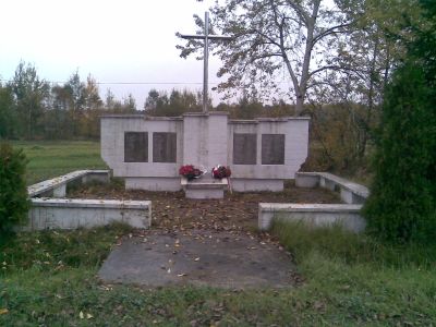
Pacyfikacja wsi Strużki, World War II memorial site in Strużki, Poland
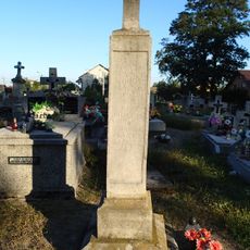
Pacyfikacja wsi Strużki is a white limestone memorial with a steel cross mounted on top, displaying the names of those killed. The structure stands in a central location and features detailed inscriptions documenting the tragic 1943 events.
German forces carried out a massacre in this village in 1943 as retaliation against local resistance movements. This devastating event reshaped the community's identity and prompted later generations to build the memorial.
The name refers to pacification, a term for violent suppression that Polish speakers understand as a dark chapter. For locals, this site remains a place where collective memory and mourning come together each year.
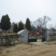
The site is easily accessible and centrally located within the village, making it suitable for visitors of all ages and mobility levels. Annual remembrance ceremonies gather both local residents and visitors throughout the year.
The monument was built decades after the war, allowing the community time to heal before creating a permanent remembrance structure. The limestone itself comes from a quarry near Pińczów, connecting the memorial to the wider regional landscape.
Height: 5.5 m
GPS coordinates: 50.47500,21.35750
Latest update: December 14, 2025 18:05
Camaldolese monastery complex in Rytwiany
9.6 km
Most w Połańcu
5.6 km
Kościuszko Mound in Połaniec
7.3 km
Church of St. Adalbert in Gawłuszowice
7.1 km
Saint Martin church in Połaniec
6.9 km
Church of the Visitation in Niekrasów
3.4 km
Saint Bartholomew church in Padew Narodowa
10.8 km
Our Lady of Sorrows church in Strzegom
5 km
Saint Stanislaus church in Osiek, Świętokrzyskie Voivodeship
7.9 km
Wooden synagogue from Połaniec
7.2 km
Our Lady Help of Christians church in Połaniec
7.9 km
Parish cemetery in Połaniec
6.6 km
Parish cemetery in Strzegom, Świętokrzystkie Voivodeship
5.1 km
Parish cemetery in Niekrasów
3.4 km
Zespół dworski
6.1 km
Cmentarz
10.8 km
Church of the Annunciation in Rytwiany
9.6 km
Wooden bell tower in Niekrasów
3.2 km
North wing of the Camaldolese monastery in Rytwiany
9.6 km
West wing of the Camaldolese monastery in Rytwiany
9.6 km
South wing of the Camaldolese monastery in Rytwiany
9.6 km
East gate to Camaldolese monastery in Rytwiany
9.6 km
Plebania
10.8 km
Stara plebania, ob. dom sióstr dominikanek
10.8 km
Kościół św. Bartłomieja Apostoła
10.8 km
Zespół kościoła św. Bartłomieja Apostoła
10.8 km
Dwór
6.1 km
West gate to Camaldolese monastery in Rytwiany
9.7 kmVisited this place? Tap the stars to rate it and share your experience / photos with the community! Try now! You can cancel it anytime.
Discover hidden gems everywhere you go!
From secret cafés to breathtaking viewpoints, skip the crowded tourist spots and find places that match your style. Our app makes it easy with voice search, smart filtering, route optimization, and insider tips from travelers worldwide. Download now for the complete mobile experience.
A unique approach to discovering new places❞
— Le Figaro
All the places worth exploring❞
— France Info
A tailor-made excursion in just a few clicks❞
— 20 Minutes