Chest opened
+${chestReward.xp} XP
Explorer
NOUVEAU ×${chestReward.collectible.quantity}
tapez pour fermer

See the monuments around you in AR Open chests in the app

Around Us is built for your phone — point your camera at the streets and discover the monuments and places around you in augmented reality. Around Us is built for your phone — chests unlock when you walk, explore and capture nearby places.

•

Enable Location

We need your location to show you interesting places around you

Discover nearby places

Find interesting locations and hidden gems around you

Precise directions

Get accurate directions and distances to places

Your location is never shared with other users. It's only used when you tap the location button.

Citânia de Briteiros

Log in to your account

Start exploring — it's free

Trusted by 93,134 travelers worldwide

Continue with Google
Continue with Apple
or

We will send you a code to connect

By continuing, you accept our Terms and Conditions and our Privacy Policy

Check your inbox

We've sent a pincode in your inbox. Please enter the code below.

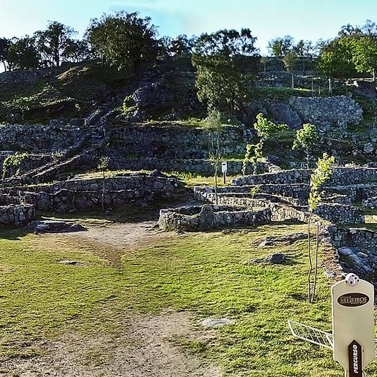
Citânia de Briteiros, Archaeological site in Briteiros São Salvador, Portugal.

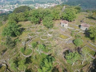
Citânia de Briteiros is an archaeological site on Monte de São Romão with the remains of a Celtic settlement. The hillfort contains paved streets, stone walls, and the outlines of about 150 round houses that formed a fortified community.

The settlement was founded in the 2nd century BCE and remained inhabited until the 2nd century CE. The transition to Roman times gradually altered the site's structure, though Celtic foundations remained visible beneath later changes.

The site's name, Citânia, comes from the Latin civitas, meaning a fortified town. Visitors can see the reconstructed dwellings that Francisco Martins Sarmento built in the 1870s, and the Pedra Formosa, a carved stone slab from one of the bathhouses, now kept in the Martins Sarmento Society museum in Guimarães.

The site sits on a hillside and is easy to explore, with clear paths and building outlines visible throughout. Wear comfortable shoes as the terrain is uneven and some sections slope steeply.

The visible ruins date mostly from the last two centuries BCE, yet the hill was used long before: Atlantic Bronze Age rock engravings covered Monte de São Romão, and many engraved boulders were cut up to build the ramparts and family compounds. Excavations also found a medieval chapel and graveyard on the acropolis.

The community of curious travelers

AroundUs brings together thousands of curated places, local tips, and hidden gems, enriched daily by 93,134 contributors worldwide.
Start exploring
Inception
2 BCE
GPS coordinates
41.52811,-8.31648
Latest update
October 28, 2026 20:33
Reviews
Share your experience

No review yet

Discussions
Start a discussion...

No discussion yet

« Citânia de Briteiros - Archaeological site in Briteiros São Salvador, Portugal » is provided by Around Us (aroundus.com). Images and texts are derived from Wikimedia project under a Creative Commons license. You are allowed to copy, distribute, and modify copies of this page, under the conditions set by the license, as long as this note is clearly visible.

Discover hidden gems everywhere you go!

From secret cafés to breathtaking viewpoints, skip the crowded tourist spots and find places that match your style. Our app makes it easy with voice search, smart filtering, route optimization, and insider tips from travelers worldwide. Download now for the complete mobile experience.

Around Us App Screenshot
❝

A unique approach to discovering new places❞

— Le Figaro

❝

All the places worth exploring❞

— France Info

❝

A tailor-made excursion in just a few clicks❞

— 20 Minutes

Around Us
Travel Guide & Maps
Download

Send to your phone

QR Code
1

Open the camera app on your mobile.

2

Point at the QR code with your camera. A notification will appear.

3

Tap the notification to open the link.
