Ruínas de São Miguel de Odrinhas

Log in to your account

AroundUs is a community-driven map of interesting places, built by curious explorers like you. It grows with every review, story, and photo you share.
Connect to save your favorite spots, contribute locations, and create personalized routes.
By continuing, you accept our Terms and Conditions and our Privacy Policy
Add to collection
Map
Suggest a change
Share

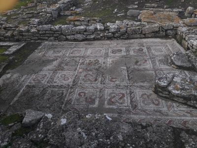
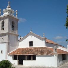
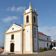
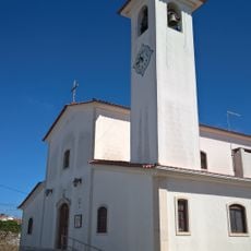
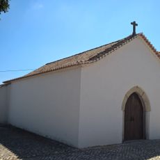
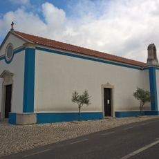
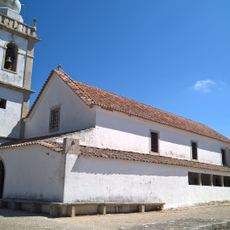
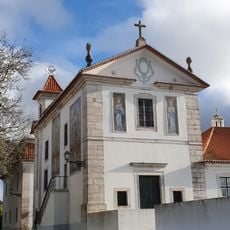
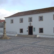
Ruínas de São Miguel de Odrinhas, Roman necropolis and chapel in São João das Lampas, Portugal.

Ruínas de São Miguel de Odrinhas is a Roman villa site with a chapel in São João das Lampas that was settled from the first century BC onward. Excavations have revealed stone walls, geometric mosaic floors, and a vaulted structure from the second century, along with a cemetery layer containing burials from a later medieval period.

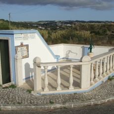
The original estate was established in the first century BC and underwent several construction phases until the fourth century AD. The site was eventually abandoned, but a Christian chapel was later built over the ruins, transforming the area into a burial ground.

The chapel was built directly over Roman foundations, showing how early Christian communities created sacred places on sites that already held meaning for earlier generations. Walking through the grounds today, you notice how different periods of faith and settlement have left their marks side by side.

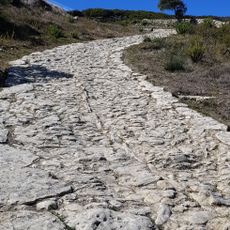
The site is best explored during daylight hours since the excavated layers and details are easier to see with natural light. Wear comfortable shoes with good grip, as the ground is uneven and can be muddy, especially after rain.

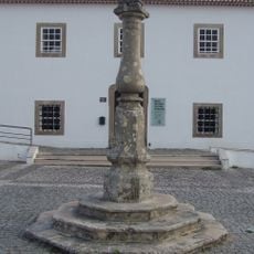
Carved inscriptions on stones throughout the site span two thousand years from ancient times through the 19th century, documenting the long occupation of the place. These inscribed objects offer clues about the different people who called this site home and left their marks across centuries.

Location: São João das Lampas e Terrugem

Part of: Archaeological Museum of São Miguel de Odrinhas

GPS coordinates: 38.88692,-9.36624

Latest update: December 14, 2025 13:00

Photos
Around this place
Palace of Mafra
Portugal

Palace of Mafra

6.6 km
Cheleiros
Portugal

Cheleiros

2 km
Conjunto Megalítico de Barreira
Portugal

Conjunto Megalítico de Barreira

518 m
Basilica of Our Lady and Saint Anthony of Mafra
Portugal

Basilica of Our Lady and Saint Anthony of Mafra

6.5 km
The six organs in the Palace of Mafra
Portugal

The six organs in the Palace of Mafra

6.6 km
Igreja de Santo André
Portugal

Igreja de Santo André

6 km
Ponte antiga em Cheleiros
Portugal

Ponte antiga em Cheleiros

3.4 km
Calçada romana da Catribana
Portugal

Calçada romana da Catribana

4.1 km
Igreja de São João Degolado, paroquial de Terrugem, e respetivo adro
Portugal

Igreja de São João Degolado, paroquial de Terrugem, e respetivo adro

4.8 km
Igreja de Nossa Senhora da Purificação de Montelavar e respetivo adro
Portugal

Igreja de Nossa Senhora da Purificação de Montelavar e respetivo adro

4 km
Church of Nossa Senhora da Conceição
Portugal

Church of Nossa Senhora da Conceição

5.4 km
Igreja Paroquial de Cheleiros
Portugal

Igreja Paroquial de Cheleiros

3.4 km
Igreja de São José de Vila Verde
Portugal

Igreja de São José de Vila Verde

5.6 km
Fonte de Armês
Portugal

Fonte de Armês

4.6 km
Pelourinho de Mafra
Portugal

Pelourinho de Mafra

6.4 km
Aqueduto das Águas Livres, seus aferentes e correlacionados (concelho de Sintra: freguesias de Almargem do Bispo, Casal de Cambra, Belas, Agualva-Cacém e Queluz)
Portugal

Aqueduto das Águas Livres, seus aferentes e correlacionados (concelho de Sintra: freguesias de Almargem do Bispo, Casal de Cambra, Belas, Agualva-Cacém e Queluz)

3.8 km
Archaeological Museum of São Miguel de Odrinhas
Portugal

Archaeological Museum of São Miguel de Odrinhas

78 m
Praia da Samarra
Portugal

Praia da Samarra

6.1 km
Cascatas do Mourão
Portugal

Cascatas do Mourão

4.8 km
Penedo de Lexim
Portugal

Penedo de Lexim

4.7 km
Capela de São Sebastião (Terrugem)
Portugal

Capela de São Sebastião (Terrugem)

4.6 km
Capela do Espírito Santo
Portugal

Capela do Espírito Santo

4 km
Câmara Municipal e Cadeia Comarcã de Mafra
Portugal

Câmara Municipal e Cadeia Comarcã de Mafra

6.4 km
Cascata de Fervença
Portugal

Cascata de Fervença

5.3 km
Pelourinho de Cheleiros
Portugal

Pelourinho de Cheleiros

3.2 km
Igreja de São João Baptista, matriz de São João das Lampas, e respetivo adro
Portugal

Igreja de São João Baptista, matriz de São João das Lampas, e respetivo adro

3.1 km
Capela de Nossa Senhora do Ar
Portugal

Capela de Nossa Senhora do Ar

5.8 km
Museu Municipal Prof. Raúl de Almeida
Portugal

Museu Municipal Prof. Raúl de Almeida

6.4 km
Show the full map
Reviews

Visited this place? Tap the stars to rate it and share your experience / photos with the community! Try now! You can cancel it anytime.

« Ruínas de São Miguel de Odrinhas - Roman necropolis and chapel in São João das Lampas, Portugal » is provided by Around Us (aroundus.com). Images and texts are derived from Wikimedia project under a Creative Commons license. You are allowed to copy, distribute, and modify copies of this page, under the conditions set by the license, as long as this note is clearly visible.

Discover hidden gems everywhere you go!

From secret cafés to breathtaking viewpoints, skip the crowded tourist spots and find places that match your style. Our app makes it easy with voice search, smart filtering, route optimization, and insider tips from travelers worldwide. Download now for the complete mobile experience.

Around Us App Screenshot

A unique approach to discovering new places

Le Figaro

All the places worth exploring

France Info

A tailor-made excursion in just a few clicks

20 Minutes