Enable Location

We need your location to show you interesting places around you

Discover nearby places

Find interesting locations and hidden gems around you

Precise directions

Get accurate directions and distances to places

Your location is never shared with other users. It's only used when you tap the location button.

Upper Tuloma Reservoir

Log in to your account

Start exploring — it's free

Trusted by 62,422 travelers worldwide

Continue with Google
Continue with Apple
or

We will send you a code to connect

By continuing, you accept our Terms and Conditions and our Privacy Policy

Check your inbox

We've sent a pincode in your inbox. Please enter the code below.

Upper Tuloma Reservoir

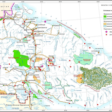
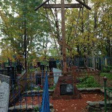
Upper Tuloma Reservoir, reservoir in Russia

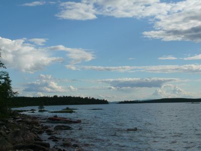
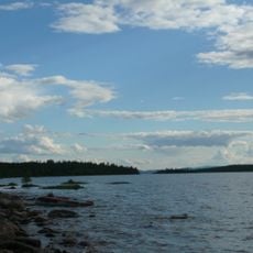
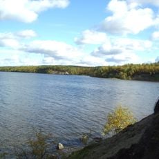
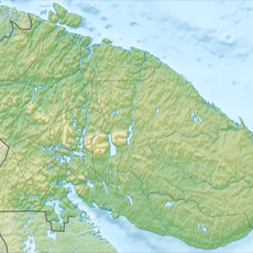
The Upper Tuloma Reservoir is a large body of water in Murmansk Oblast formed by a dam across the Tuloma River. Its surface stretches across the landscape surrounded by rocky terrain and sparse vegetation typical of the Kola Peninsula.

The reservoir was built in the mid-1960s and changed the natural flow of the Tuloma River. It was created in the location where the lake Notozero once stood, now submerged beneath the water.

The reservoir takes its name from the Tuloma River that flows through the region. For local residents, it is an ordinary part of the landscape that reflects their relationship with the natural environment and the practical use of water resources in the north.

The area is easily accessible via a few roads and paths leading close to the banks. It is quiet and not crowded, making it suitable for peaceful visits in open nature, though visitors should know that winter months are long and the water freezes over.

The original lake Notozero disappeared beneath the water surface of the new reservoir and no longer exists as a separate body of water. This reminds visitors how large-scale human efforts can transform the natural landscape.

The community of curious travelers

AroundUs brings together thousands of curated places, local tips, and hidden gems, enriched daily by 60,000 contributors worldwide.

Start exploring
Location
Inception
1965
GPS coordinates
68.58333,31.20000
Latest update
February 9, 2026 08:23
Around this place
Kola Bay Bridge
Russian Federation

Kola Bay Bridge

82.6 km
Annunciation Church
Russian Federation

Annunciation Church

80.7 km
Nikolai M. Knipovich Polar Research Institute of Marine Fisheries and Oceanography
Russian Federation

Nikolai M. Knipovich Polar Research Institute of Marine Fisheries and Oceanography

86.2 km
Resurrection Church
Russian Federation

Resurrection Church

81 km
Туломский заказник
Russian Federation

Туломский заказник

47.8 km
Catholic Church of Archangel Michael
Russian Federation

Catholic Church of Archangel Michael

83.9 km
Лапландский лес
Russian Federation

Лапландский лес

29.9 km
Церковь Варлаама Керетского
Russian Federation

Церковь Варлаама Керетского

80.9 km
Кольский некрополь
Russian Federation

Кольский некрополь

81 km
Lower Tuloma Reservoir
Russian Federation

Lower Tuloma Reservoir

62.1 km
Центральная городская библиотека Мурманска
Russian Federation

Центральная городская библиотека Мурманска

84.8 km
Заячья Тундра
Russian Federation

Заячья Тундра

81.6 km
Штаб-бункер 14-й армии
Russian Federation

Штаб-бункер 14-й армии

85.2 km
Памятник С. М. Кирову
Russian Federation

Памятник С. М. Кирову

70.5 km
Saint Nicholas Orthodox cathedral in Murmansk
Russian Federation

Saint Nicholas Orthodox cathedral in Murmansk

85.4 km
Здание деревянной гостиницы
Russian Federation

Здание деревянной гостиницы

70.7 km
Kinoteatr Atlantika
Russian Federation

Kinoteatr Atlantika

84.4 km
Братская могила партизан отрядов «Советский Мурман» и «Большевик Заполярья»
Russian Federation

Братская могила партизан отрядов «Советский Мурман» и «Большевик Заполярья»

75.8 km
Дом культуры (клуб) «Энергетик»
Russian Federation

Дом культуры (клуб) «Энергетик»

70.4 km
Здание казначейства Мурманской области
Russian Federation

Здание казначейства Мурманской области

85.9 km
Путный крест (деревянный)
Russian Federation

Путный крест (деревянный)

80.7 km
Рубеж обороны советских войск в 1941-1944 гг. на высоте 314,9: 3 ДОТа, траншеи, братская могила
Russian Federation

Рубеж обороны советских войск в 1941-1944 гг. на высоте 314,9: 3 ДОТа, траншеи, братская могила

83.1 km
Индивидуальные могилы (50 могил) периода Великой Отечественной войны 1941-1945 гг.
Russian Federation

Индивидуальные могилы (50 могил) периода Великой Отечественной войны 1941-1945 гг.

69.6 km
Building of former Treasury of uyezd
Russian Federation

Building of former Treasury of uyezd

80.5 km
Здание морского колледжа имени И. И. Месяцева
Russian Federation

Здание морского колледжа имени И. И. Месяцева

86.1 km
Здание склада
Russian Federation

Здание склада

85.6 km
Жилой дом
Russian Federation

Жилой дом

86.2 km
Памятник 6-й героической комсомольской батарее
Russian Federation

Памятник 6-й героической комсомольской батарее

86.2 km
Show the full map
« Upper Tuloma Reservoir - reservoir in Russia » is provided by Around Us (aroundus.com). Images and texts are derived from Wikimedia project under a Creative Commons license. You are allowed to copy, distribute, and modify copies of this page, under the conditions set by the license, as long as this note is clearly visible.

Discover hidden gems everywhere you go!

From secret cafés to breathtaking viewpoints, skip the crowded tourist spots and find places that match your style. Our app makes it easy with voice search, smart filtering, route optimization, and insider tips from travelers worldwide. Download now for the complete mobile experience.

Around Us App Screenshot

A unique approach to discovering new places

Le Figaro

All the places worth exploring

France Info

A tailor-made excursion in just a few clicks

20 Minutes

Around Us
Travel Guide & Maps
Download

Send to your phone

QR Code
1

Open the camera app on your mobile.

2

Point at the QR code with your camera. A notification will appear.

3

Tap the notification to open the link.