Enable Location

We need your location to show you interesting places around you

Discover nearby places

Find interesting locations and hidden gems around you

Precise directions

Get accurate directions and distances to places

Your location is never shared with other users. It's only used when you tap the location button.

Kutulukskoye Vodokhranilishche

Log in to your account

Start exploring — it's free

Trusted by 62,396 travelers worldwide

Continue with Google
Continue with Apple
or

We will send you a code to connect

By continuing, you accept our Terms and Conditions and our Privacy Policy

Check your inbox

We've sent a pincode in your inbox. Please enter the code below.

Kutulukskoye Vodokhranilishche

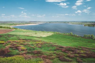
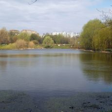
Kutulukskoye Vodokhranilishche, reservoir in Russia

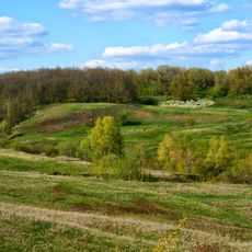
Kutulukskoye Vodokhranilishche is an artificial reservoir created on the Kutuluk River in its middle section. The water body stretches nearly 14 kilometers long and varies between 1.4 and 2.5 kilometers wide, with an average depth near 5 meters and banks that slope gently into shallow water.

The reservoir was planned in 1935 and construction of the earthen dam began in 1938. Filling started in 1941 and it reached its normal water level by 1943.

The reservoir serves as a gathering place where local fishermen practice their craft and farmers rely on its water supply. The shoreline draws residents seeking quiet moments and connection with the natural rhythm of the region.

The shoreline is easily accessible with shallow areas suitable for swimming and fishing. The best time to visit is from late spring through early fall when water is warm and weather conditions are pleasant.

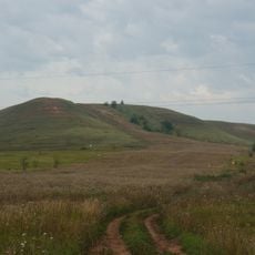
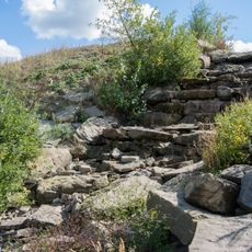
The Kutulukskie Yary cliffs and the ancient Kutulukskaya Duba oak forest are protected areas adjacent to the reservoir. These natural features form part of a regional park designed to preserve the local environment.

The community of curious travelers

AroundUs brings together thousands of curated places, local tips, and hidden gems, enriched daily by 60,000 contributors worldwide.

Start exploring
Elevation above the sea
61 m
GPS coordinates
53.20000,51.50000
Latest update
February 9, 2026 08:23
Around this place
Samara Arena
Russian Federation

Samara Arena

84.5 km
Buzuluksky Bor National Park
Russian Federation

Buzuluksky Bor National Park

46.5 km
Monument Il-2 ground-attack aircraft
Russian Federation

Monument Il-2 ground-attack aircraft

85.3 km
Samara Mosque
Russian Federation

Samara Mosque

86.2 km
Savior Transfiguration monastery
Russian Federation

Savior Transfiguration monastery

69.7 km
Kirov vehicle bridge
Russian Federation

Kirov vehicle bridge

79.6 km
Tikhvin Virgin Monastery
Russian Federation

Tikhvin Virgin Monastery

69.7 km
Saints Cyril and Methodius Church
Russian Federation

Saints Cyril and Methodius Church

86.1 km
50th October park
Russian Federation

50th October park

82.3 km
Samara railway museum
Russian Federation

Samara railway museum

80.3 km
Krasnoyarskaya Fortress
Russian Federation

Krasnoyarskaya Fortress

80.1 km
Victory park
Russian Federation

Victory park

86.5 km
Voronezhskije Ozera park
Russian Federation

Voronezhskije Ozera park

85.2 km
Holy Resurrection Monastery
Russian Federation

Holy Resurrection Monastery

83.8 km
Molodezhnyi park
Russian Federation

Molodezhnyi park

84 km
Бугурусланский Покровский монастырь
Russian Federation

Бугурусланский Покровский монастырь

79.3 km
Sernovodny Hill
Russian Federation

Sernovodny Hill

78.9 km
Южный мост (Самара)
Russian Federation

Южный мост (Самара)

87.1 km
Դ. Ն. Ֆլորովի անվան կենդանաբանական թանգարան
Russian Federation

Դ. Ն. Ֆլորովի անվան կենդանաբանական թանգարան

86.4 km
ЦСК ВВС (стадион, Самара)
Russian Federation

ЦСК ВВС (стадион, Самара)

84.8 km
Desert roses of Chubovka
Russian Federation

Desert roses of Chubovka

67.3 km
Скульптура "У слона"
Russian Federation

Скульптура "У слона"

87.7 km
Храм Святой Троицы города Бугуруслана
Russian Federation

Храм Святой Троицы города Бугуруслана

76.7 km
Russian Federation

Krasnogwardiejec

81.8 km
Russian Federation

Чувикс

43.1 km
Russian Federation

1192 км

16.3 km
Waterfall in Syreyka
Russian Federation

Waterfall in Syreyka

63.6 km
Golden cave
Russian Federation

Golden cave

65.2 km
Show the full map
« Kutulukskoye Vodokhranilishche - reservoir in Russia » is provided by Around Us (aroundus.com). Images and texts are derived from Wikimedia project under a Creative Commons license. You are allowed to copy, distribute, and modify copies of this page, under the conditions set by the license, as long as this note is clearly visible.

Discover hidden gems everywhere you go!

From secret cafés to breathtaking viewpoints, skip the crowded tourist spots and find places that match your style. Our app makes it easy with voice search, smart filtering, route optimization, and insider tips from travelers worldwide. Download now for the complete mobile experience.

Around Us App Screenshot

A unique approach to discovering new places

Le Figaro

All the places worth exploring

France Info

A tailor-made excursion in just a few clicks

20 Minutes

Around Us
Travel Guide & Maps
Download

Send to your phone

QR Code
1

Open the camera app on your mobile.

2

Point at the QR code with your camera. A notification will appear.

3

Tap the notification to open the link.