Enable Location

We need your location to show you interesting places around you

Discover nearby places

Find interesting locations and hidden gems around you

Precise directions

Get accurate directions and distances to places

Your location is never shared with other users. It's only used when you tap the location button.

Kuzbassky Bridge, Kemerovo

Log in to your account

Start exploring — it's free

Trusted by 63,056 travelers worldwide

Continue with Google
Continue with Apple
or

We will send you a code to connect

By continuing, you accept our Terms and Conditions and our Privacy Policy

Check your inbox

We've sent a pincode in your inbox. Please enter the code below.

Kuzbassky Bridge, Kemerovo
Discussion Reviews 1 Photos
1.9k Popularity

Kuzbassky Bridge, Kemerovo, Transportation bridge in Kemerovo, Russia.

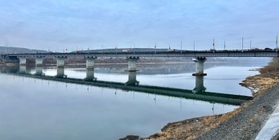
Kuzbassky Bridge is a road crossing over the Tom River in Kemerovo, measuring 627 meters long and about 27 meters wide. It carries cars, trucks, and pedestrians daily between different parts of the city on both sides of the river.

Construction of this bridge began in 1972 as part of Soviet infrastructure development in the coal mining region. It opened to traffic in 1981 and became crucial for connecting the rapidly expanding city.

The bridge represents a significant Soviet-era engineering achievement that transformed the connectivity patterns of local communities across the Tom River.

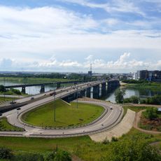
The bridge is well accessible for cars, trucks, and pedestrians and serves as a main traffic artery throughout the day. During morning and evening rush hours it can get crowded, so expect to wait when crossing on foot.

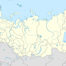
Located at coordinates 55.36389°N and 86.13028°E, this bridge stands as a central element in the transportation network of the Kuzbass coal mining region.

The community of curious travelers

AroundUs brings together thousands of curated places, local tips, and hidden gems, enriched daily by 60,000 contributors worldwide.

Start exploring
Location
Inception
1972
Official opening
1981
Length
627 m
Width
26.8 m
GPS coordinates
55.36389,86.13028
Latest update
December 14, 2025 11:02
Around this place
Monument to the Warrior Liberator
Russian Federation

Monument to the Warrior Liberator

1.4 km
Tomskaya Pisanitsa Museum
Russian Federation

Tomskaya Pisanitsa Museum

46.6 km
Angels' Park
Russian Federation

Angels' Park

4 km
Russian Federation

Monument in Memory of Kuzbass Miners

3.5 km
Boris Shtokolov Philharmonic Kemerov
Russian Federation

Boris Shtokolov Philharmonic Kemerov

2.6 km
Cathedral of the Theotokos of the Sign
Russian Federation

Cathedral of the Theotokos of the Sign

3.3 km
Krasnaya Gorka Museum Complex
Russian Federation

Krasnaya Gorka Museum Complex

3.9 km
Munira Kemerovo Mosque
Russian Federation

Munira Kemerovo Mosque

27.1 km
Lunacharsky Drama Theatre
Russian Federation

Lunacharsky Drama Theatre

3.3 km
Kuznetskiy Bridge, Kemerovo
Russian Federation

Kuznetskiy Bridge, Kemerovo

3.5 km
Immaculate Heart of Mary Church, Kemerovo
Russian Federation

Immaculate Heart of Mary Church, Kemerovo

3.9 km
State Scientific Library of Kuzbass. V.D. Fedorova
Russian Federation

State Scientific Library of Kuzbass. V.D. Fedorova

4 km
Кемеровский областной краеведческий музей
Russian Federation

Кемеровский областной краеведческий музей

3.1 km
Russian Federation

123 km

31.9 km
Rutgers house, Kemerovo
Russian Federation

Rutgers house, Kemerovo

3.9 km
137 km
Russian Federation

137 km

35.2 km
130 km
Russian Federation

130 km

32.7 km
Vesennyaya Street
Russian Federation

Vesennyaya Street

3.1 km
115 km
Russian Federation

115 km

28.4 km
Дедюево (разъезд)
Russian Federation

Дедюево (разъезд)

23.7 km
Юрьевка
Russian Federation

Юрьевка

48.3 km
79 km
Russian Federation

79 km

52 km
96 km
Russian Federation

96 km

42.5 km
Kemerovo Oblast Museum of Fine Arts
Russian Federation

Kemerovo Oblast Museum of Fine Arts

3.2 km
Kemerovo State Circus
Russian Federation

Kemerovo State Circus

2.9 km
Часовня иконы Божией Матери «Всех Скорбящих Радость»
Russian Federation

Часовня иконы Божией Матери «Всех Скорбящих Радость»

2.6 km
Chapel of Our Lady of the Consolation in Sorrow, Kemerovo
Russian Federation

Chapel of Our Lady of the Consolation in Sorrow, Kemerovo

4 km
Памятник В. И. Ленину
Russian Federation

Памятник В. И. Ленину

2.8 km
Show the full map
Reviews
Share your experience

No review yet

Discussions
Start a discussion...

No discussion yet

« Kuzbassky Bridge, Kemerovo - Transportation bridge in Kemerovo, Russia » is provided by Around Us (aroundus.com). Images and texts are derived from Wikimedia project under a Creative Commons license. You are allowed to copy, distribute, and modify copies of this page, under the conditions set by the license, as long as this note is clearly visible.

Discover hidden gems everywhere you go!

From secret cafés to breathtaking viewpoints, skip the crowded tourist spots and find places that match your style. Our app makes it easy with voice search, smart filtering, route optimization, and insider tips from travelers worldwide. Download now for the complete mobile experience.

Around Us App Screenshot

A unique approach to discovering new places

Le Figaro

All the places worth exploring

France Info

A tailor-made excursion in just a few clicks

20 Minutes

Around Us
Travel Guide & Maps
Download

Send to your phone

QR Code
1

Open the camera app on your mobile.

2

Point at the QR code with your camera. A notification will appear.

3

Tap the notification to open the link.