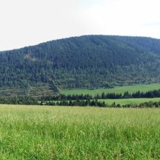
Skorušina, Mountain summit in Tvrdošín District, Slovakia
Skorušina, at 1,313.8 m, is the highest summit of the Skorušinské Hills, about 8 km southeast of Trstená. It lies on the main ridge between Mikulovka, Brezový vrch and Blatná, on the cadastral borders of Vitanová, Habovka and Brezovica. The whole massif is densely forested; a 13 m steel lookout tower and a tourist shelter stand on the summit.
Skorušina lies on the main ridge of the Skorušinské Hills, and the long grassy stretch of the red trail from Oravice to the summit is still visible on satellite images. The slopes once held fields, meadows and pastures that have since grown over or are in the final stage of being reclaimed by forest. The marked routes now followed by walkers are the red trail from Oravice through Blatná and the green trail from Trstená via Javorinky.
The name Skorušina comes from the Slovak word for the mountain range, and the peak lies on the cadastral borders of Vitanová, Habovka and Brezovica. The long grassy stretch of the red trail from Oravice to the summit is the most panoramic section, while former fields and pastures on the slopes are now overgrown but still visible on satellite maps.
Marked trails reach the summit from Trstená, from Brezovica via Javorinky (1,122.7 m), and from Oravský Biely Potok or Oravice. The red trail from Oravice via Blatná and Skorušina to Mikulovka and Oravský Biely Potok takes 4 h 25 min one way and 4 h 20 min the other. The long grassy stretch from Oravice to Skorušina is open and view-rich.
A 13-meter steel observation tower sits at the summit, offering panoramic views across the Orava basin, Orava Dam, Roháč ridge, and Veľký Choč Hill. This viewpoint draws photographers looking to capture the landscape from multiple angles.
The community of curious travelers
AroundUs brings together thousands of curated places, local tips, and hidden gems, enriched daily by 94,701 contributors worldwide.