Žiar, Mountain range in the Trenčín Region, Slovakia
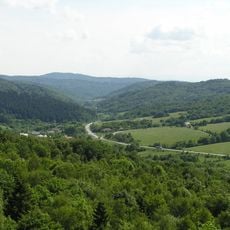
Žiar is a forested mountain range in the Trenčín Region of northwestern Slovakia, part of the Fatra-Tatra Area of the Inner Western Carpathians. Its chain runs from northwest to southeast in a curved arc about 30 kilometres long and 5 to 7 kilometres wide. The highest point is Chlieviská at 1,024 metres, in the northern part of the range.
Žiar is a core mountain range of the Fatra-Tatra Area of the Inner Western Carpathians, lying between the Hornonitrianska kotlina basin to the west and the Turcianska kotlina basin to the east. It borders the Malá Fatra to the north, the Kremnické vrchy to the southeast and the Vtáčnik range to the south. The Vyšehradské sedlo saddle (579 m) separates its Sokol and Vyšehrad subunits.
The name Žiar likely relates to the Slovak word for a burnt or cleared place, žiar, referring to land cleared by fire for pasture. The range is divided into four geomorphological subunits: Sokol, Vyšehrad, Horeňovo and Rovne, each named after its highest summit. The Vyšehradské sedlo pass at 579 m separates Sokol from Vyšehrad.
The range lies in the Trenčín Region of northwestern Slovakia, between the Hornonitrianska kotlina basin to the west and the Turčianska kotlina basin to the east, with the Malá Fatra to the north. The Vyšehradské sedlo saddle at 579 m separates the Sokol and Vyšehrad subunits. The chain runs as a curved arc about 30 km long and 5 to 7 km wide.
The range forms a curved arc 30 kilometres long and 5 to 7 kilometres wide, running northwest to southeast between the Hornonitrianska kotlina basin and the Turcianska kotlina basin. Almost the whole chain is forested, and its highest point, Chlieviská at 1,024 metres, stands in the northern part of the group.
The community of curious travelers
AroundUs brings together thousands of curated places, local tips, and hidden gems, enriched daily by 94,036 contributors worldwide.