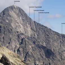
Lomnický štít, Mountain peak in High Tatras, Slovakia
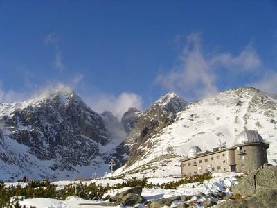
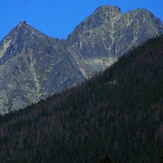
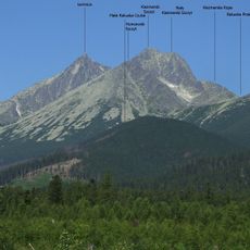
Lomnický štít is a granite summit in the High Tatras that rises to 2,634 meters (8,641 feet). The peak features two distinct summits connected by a narrow ridge with exposed rocky sections.
English explorer Robert Townson made the first documented ascent in 1793 and measured the elevation with remarkable precision. Since then, the peak has remained a target for mountaineers studying the geological structure of the range.
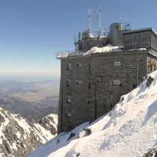
The mountain observatory and meteorological station on the summit contribute daily weather data and solar observations for scientific research.
A cable car from Tatranská Lomnica carries visitors to the summit, eliminating the need for technical climbing skills. Once at the top, visitors typically have around 50 minutes to observe the views before descending.
An observatory and meteorological station on the summit collects daily weather data and solar observations for scientific research. The extreme temperature swings between minus 31 degrees Celsius (minus 24 degrees Fahrenheit) in March and 24 degrees Celsius (75 degrees Fahrenheit) in August make these measurements particularly valuable.
Location: Poprad District
Elevation above the sea: 2,634 m
Made from material: granite
GPS coordinates: 49.19514,20.21303
Latest update: December 20, 2025 01:26
Slovakia offers a variety of natural and cultural sites, from medieval castles to the peaks of the Tatra Mountains. The country features historic cities such as Bratislava and Košice, national parks with caves and waterfalls, and Gothic religious monuments. The castles of Spiš, Bojnice, and Orava...
Pyšný štít
457 m
Weber-Spitze
814 m
Kesmarker Spitze
653 m
Lomnický Štít Observatory
536 m
Téryspitze
598 m
Veľká Vidlová veža
416 m
Durna Turniczka
319 m
Posledná veža
262 m
Cmentarzysko (Tatry)
398 m
Łomnicka Kopa
350 m
Wschodni Szczyt Wideł
363 m
Mała Poślednia Turniczka
163 m
Zębata Turnia
253 m
Łomnicki Mniszek
127 m
Łomnicki Kopiniak
195 m
Zachodni Szczyt Wideł
25 m
Kieżmarska Czuba
806 m
Durne Rogi
454 m
Łomnicki Kopiniaczek
38 m
Zadnia Durna Baszta
428 m
Pośrednia Durna Baszta
445 m
Durna Kopa
468 m
Durny Mnich
560 m
Skrajny Durny Kopiniak
416 m
Durna Czubka
426 m
Skrajna Durna Baszta
448 m
Zadni Durny Kopiniak
395 m
Pośredni Durny Kopiniak
397 mVisited this place? Tap the stars to rate it and share your experience / photos with the community! Try now! You can cancel it anytime.
Discover hidden gems everywhere you go!
From secret cafés to breathtaking viewpoints, skip the crowded tourist spots and find places that match your style. Our app makes it easy with voice search, smart filtering, route optimization, and insider tips from travelers worldwide. Download now for the complete mobile experience.
A unique approach to discovering new places❞
— Le Figaro
All the places worth exploring❞
— France Info
A tailor-made excursion in just a few clicks❞
— 20 Minutes