Pyšný štít

Log in to your account

AroundUs is a community-driven map of interesting places, built by curious explorers like you. It grows with every review, story, and photo you share.
Connect to save your favorite spots, contribute locations, and create personalized routes.
Continue with Google
Continue with Apple
Continue with X
Continue with Facebook
Continue with email
By continuing, you accept our Terms and Conditions and our Privacy Policy
Create an account

Pyšný štít

Add to collection
Map
Suggest a change
Share

Pyšný štít, Mountain summit in High Tatras, Slovakia.

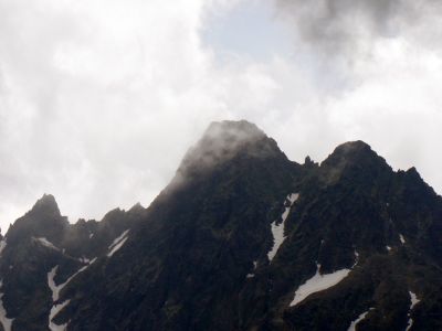
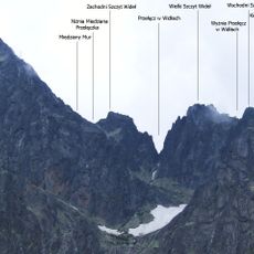
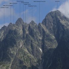
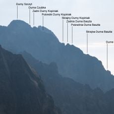
Pyšný štít is a granite peak in the High Tatras standing at 2621 meters, situated between the Mala Studena and Medena valleys. The mountain features steep, exposed sections of rock throughout its routes to the top.

The peak was first documented to be climbed in 1877 when Edmund Téry and mountain guide Martin Spitzkopf left proof of their ascent in a bottle. This climb marked an important moment in the exploration of the High Tatras.

The name means 'proud' in Slovak and describes how the peak rises prominently above the surrounding landscape. This characteristic is immediately visible to anyone viewing the rocky summit from different angles.

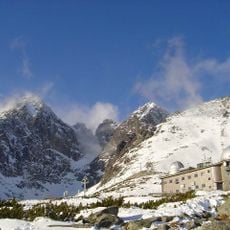
The climb from Teryho Hut takes about eight to ten hours with 600 meters of elevation gain and requires technical climbing skills. Starting early in the day and preparing with an experienced mountain guide is wise to ensure a safe journey.

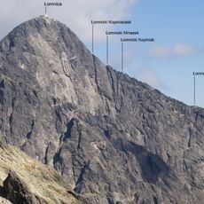
The summit ranks among the five highest peaks in Slovakia and offers views toward the nearby Lomnicky Peak from the top. Climbers often notice the contrasts between rougher granite surfaces and finely sculpted rock edges.

Location: Poprad District

Elevation above the sea: 2,621 m

Made from material: granite

GPS coordinates: 49.19759,20.20800

Latest update: December 10, 2025 15:52

Photos
Reviews

Visited this place? Tap the stars to rate it and share your experience / photos with the community! Try now! You can cancel it anytime.

« Pyšný štít - Mountain summit in High Tatras, Slovakia » is provided by Around Us (aroundus.com). Images and texts are derived from Wikimedia project under a Creative Commons license. You are allowed to copy, distribute, and modify copies of this page, under the conditions set by the license, as long as this note is clearly visible.

Discover hidden gems everywhere you go!

From secret cafés to breathtaking viewpoints, skip the crowded tourist spots and find places that match your style. Our app makes it easy with voice search, smart filtering, route optimization, and insider tips from travelers worldwide. Download now for the complete mobile experience.

Around Us App Screenshot

A unique approach to discovering new places

Le Figaro

All the places worth exploring

France Info

A tailor-made excursion in just a few clicks

20 Minutes