Chest opened
+${chestReward.xp} XP
Explorer
NOUVEAU ×${chestReward.collectible.quantity}
tapez pour fermer
Chest locked

Open chests in the app

Around Us is built for your phone — chests unlock when you walk, explore and capture nearby places.

Enable Location

We need your location to show you interesting places around you

Discover nearby places

Find interesting locations and hidden gems around you

Precise directions

Get accurate directions and distances to places

Your location is never shared with other users. It's only used when you tap the location button.

Log in to your account

Start exploring — it's free

Trusted by 72,880 travelers worldwide

Continue with Google
Continue with Apple
or

We will send you a code to connect

By continuing, you accept our Terms and Conditions and our Privacy Policy

Check your inbox

We've sent a pincode in your inbox. Please enter the code below.

Przełęcz pod Kopą Kondracką
Discussion Reviews Photo
3.5k Popularity

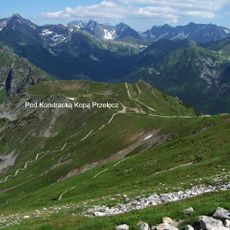
Przełęcz pod Kopą Kondracką, Mountain saddle at 1863 meters in Western Tatra Mountains, Slovakia.

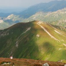
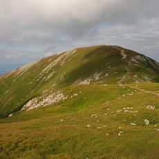
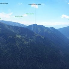
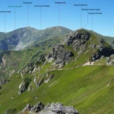
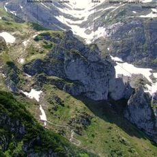
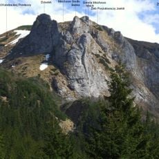
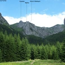
Przełęcz pod Kopą Kondracką is a mountain saddle at 1863 meters (6112 feet) in the Western Tatra Mountains, positioned between the peak of Kopà Kondracka at 2005 meters and Suchy Wierch Kondracki at 1890 meters. It marks the border between Poland and Slovakia and serves as a major crossing point connecting the valleys on either side.

The saddle was formed through geological processes that shaped the distinctive mountain features in this part of the Western Tatras. From 1889 to 1925, the Tatrzańskie Society maintained a shelter here to support mountain travelers crossing between the valleys.

The pass is locally called Kotlinkami because of its multiple tectonic depressions that create natural bowl-shaped formations in the terrain. This feature makes the location easily recognizable and memorable for those who cross it.

The route from the PTTK shelter at Hala Kondratowa to the pass takes about 1 hour 20 minutes going up and about 1 hour coming down. Pay attention to weather conditions and bring suitable gear, as the elevation and exposure can bring rapid weather changes.

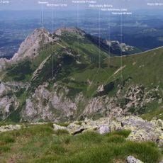
In winter, ski touring enthusiasts use the saddle as access to both sides of the border, with Dolina Cicha on the Slovak side and Dolina Kondratowa on the Polish side. This dual accessibility makes it a preferred point for ski mountaineers wanting to combine both valleys in a single tour.

The community of curious travelers

AroundUs brings together thousands of curated places, local tips, and hidden gems, enriched daily by 60,000 contributors worldwide.

Start exploring
GPS coordinates
49.23420,19.93860
Latest update
December 12, 2025 07:54
Reviews
Share your experience

No review yet

Discussions
Start a discussion...

No discussion yet

« Przełęcz pod Kopą Kondracką - Mountain saddle at 1863 meters in Western Tatra Mountains, Slovakia » is provided by Around Us (aroundus.com). Images and texts are derived from Wikimedia project under a Creative Commons license. You are allowed to copy, distribute, and modify copies of this page, under the conditions set by the license, as long as this note is clearly visible.

Discover hidden gems everywhere you go!

From secret cafés to breathtaking viewpoints, skip the crowded tourist spots and find places that match your style. Our app makes it easy with voice search, smart filtering, route optimization, and insider tips from travelers worldwide. Download now for the complete mobile experience.

Around Us App Screenshot

A unique approach to discovering new places

Le Figaro

All the places worth exploring

France Info

A tailor-made excursion in just a few clicks

20 Minutes

Around Us
Travel Guide & Maps
Download

Send to your phone

QR Code
1

Open the camera app on your mobile.

2

Point at the QR code with your camera. A notification will appear.

3

Tap the notification to open the link.