Chest opened
+${chestReward.xp} XP
Explorer
NOUVEAU ×${chestReward.collectible.quantity}
tapez pour fermer

See the monuments around you in AR Open chests in the app

Around Us is built for your phone — point your camera at the streets and discover the monuments and places around you in augmented reality. Around Us is built for your phone — chests unlock when you walk, explore and capture nearby places.

Enable Location

We need your location to show you interesting places around you

Discover nearby places

Find interesting locations and hidden gems around you

Precise directions

Get accurate directions and distances to places

Your location is never shared with other users. It's only used when you tap the location button.

Boundary stones

Log in to your account

Start exploring — it's free

Trusted by 85,198 travelers worldwide

Continue with Google
Continue with Apple
or

We will send you a code to connect

By continuing, you accept our Terms and Conditions and our Privacy Policy

Check your inbox

We've sent a pincode in your inbox. Please enter the code below.

Boundary stones
Discussion Reviews 1 Photos
1.9k Popularity

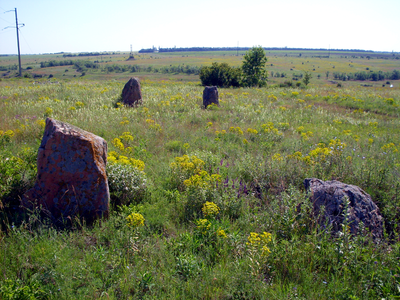
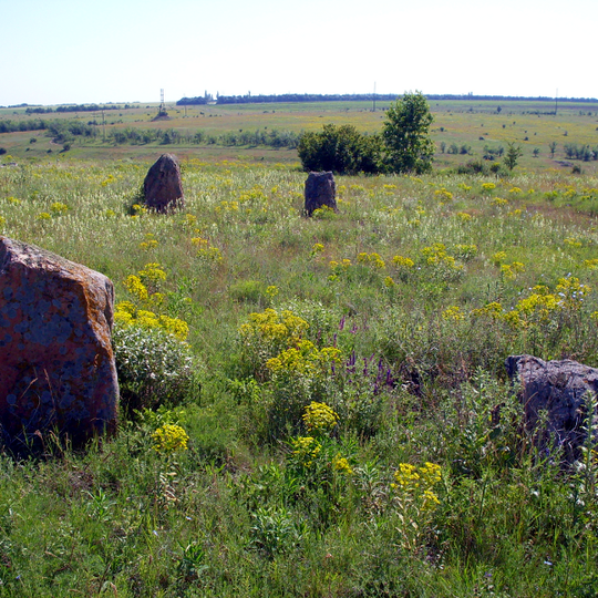
Boundary stones, Ancient stone markers in Kropyvnytskyi Raion, Ukraine.

The Boundary Stones consist of two parallel rows of stone monoliths arranged as 15 paired blocks, running from east to west. The tallest pair reaches approximately 1.50 meters (5 feet) in height, with spacing gradually increasing between consecutive pairs.

The site dates back to the late Neolithic period and was erected by people inhabiting the region at that time. These stones likely marked territorial boundaries or held ritual significance for ancient communities.

The arrangement of the stones suggests a connection to ritual practices that tracked the sun's movement. Visitors can still observe how these stones were likely oriented for specific ceremonial purposes.

The site is freely accessible and allows you to walk between the stone rows at your own pace. Wear sturdy footwear as the terrain can be uneven and muddy depending on the season.

About 20 burial mounds from the Neolithic and Bronze periods lie within roughly 2 kilometers of the stones. This concentration of ancient remains suggests the area was an important hub for communities over many centuries.

The community of curious travelers

AroundUs brings together thousands of curated places, local tips, and hidden gems, enriched daily by 60,000 contributors worldwide.

Start exploring
GPS coordinates
48.25225,32.01778
Latest update
August 30, 2026 21:15
Around this place
Ukraine

Saint Elisabeth Fortress

20.2 mi
Kirovohrad Academic Ukrainian Music and Drama Theater
Ukraine

Kirovohrad Academic Ukrainian Music and Drama Theater

21.2 mi
Khutir Nadia
Ukraine

Khutir Nadia

15.2 mi
Park of the 50th Anniversary of October, Kirovohrad
Ukraine

Park of the 50th Anniversary of October, Kirovohrad

19.8 mi
Ukraine

Nove, Kropyvnytskyi municipality

20.1 mi
Kirovohrad Oblast Council
Ukraine

Kirovohrad Oblast Council

21.2 mi
Museum of Regional Studies
Ukraine

Museum of Regional Studies

21.2 mi
Orthodox church of the Nativity of the Theotokos in Kropyvnytskyi
Ukraine

Orthodox church of the Nativity of the Theotokos in Kropyvnytskyi

20.7 mi
Great Synagogue in Kropyvnytskyi
Ukraine

Great Synagogue in Kropyvnytskyi

21.2 mi
Church of the Transfiguration, Kropyvnytskyi
Ukraine

Church of the Transfiguration, Kropyvnytskyi

20.9 mi
Kholodnyi Yar National Nature Park
Ukraine

Kholodnyi Yar National Nature Park

12.9 mi
Khutir Nadia Park
Ukraine

Khutir Nadia Park

20.9 mi
Park Peremohy
Ukraine

Park Peremohy

19.6 mi
State Archive of Kirovohrad Oblast
Ukraine

State Archive of Kirovohrad Oblast

20.1 mi
Saint Volodymyr the Great church, Kropyvnytskyi
Ukraine

Saint Volodymyr the Great church, Kropyvnytskyi

20.9 mi
Intercession of the Theotokos church, Kropyvnytskyi
Ukraine

Intercession of the Theotokos church, Kropyvnytskyi

21.3 mi
Memorial museum of Oleksandr Osmerkin
Ukraine

Memorial museum of Oleksandr Osmerkin

21.3 mi
40 Arkhitektora Pauchenka Street, Kropyvnytskyi
Ukraine

40 Arkhitektora Pauchenka Street, Kropyvnytskyi

21.2 mi
Ivan Karpenko-Karyi Memorial Museum
Ukraine

Ivan Karpenko-Karyi Memorial Museum

20.6 mi
Elisabetin luostari
Ukraine

Elisabetin luostari

21.2 mi
Козачий острів
Ukraine

Козачий острів

20.9 mi
Church of the Ascension, Bobrynets
Ukraine

Church of the Ascension, Bobrynets

15.1 mi
Музей Генріха Нейгауза
Ukraine

Музей Генріха Нейгауза

21.2 mi
Saint Nicholas church, Bobrynets
Ukraine

Saint Nicholas church, Bobrynets

15.5 mi
Shumok
Ukraine

Shumok

14.5 mi
Історичний музей «Євреї Єлисаветграда»
Ukraine

Історичний музей «Євреї Єлисаветграда»

21.1 mi
Кіровоградський державний музей музичної культури імені Кароля Шимановського
Ukraine

Кіровоградський державний музей музичної культури імені Кароля Шимановського

21.2 mi
Chobitok
Ukraine

Chobitok

12.1 mi
Show the full map
Reviews
Share your experience

No review yet

Discussions
Start a discussion...

No discussion yet

« Boundary stones - Ancient stone markers in Kropyvnytskyi Raion, Ukraine » is provided by Around Us (aroundus.com). Images and texts are derived from Wikimedia project under a Creative Commons license. You are allowed to copy, distribute, and modify copies of this page, under the conditions set by the license, as long as this note is clearly visible.

Discover hidden gems everywhere you go!

From secret cafés to breathtaking viewpoints, skip the crowded tourist spots and find places that match your style. Our app makes it easy with voice search, smart filtering, route optimization, and insider tips from travelers worldwide. Download now for the complete mobile experience.

Around Us App Screenshot

A unique approach to discovering new places

Le Figaro

All the places worth exploring

France Info

A tailor-made excursion in just a few clicks

20 Minutes

Around Us
Travel Guide & Maps
Download

Send to your phone

QR Code
1

Open the camera app on your mobile.

2

Point at the QR code with your camera. A notification will appear.

3

Tap the notification to open the link.