Principality of Sealand

Log in to your account

AroundUs is a community-driven map of interesting places, built by curious explorers like you. It grows with every review, story, and photo you share.
Connect to save your favorite spots, contribute locations, and create personalized routes.
Continue with Google
Continue with Apple
Continue with X
Continue with Facebook
Continue with email
By continuing, you accept our Terms and Conditions and our Privacy Policy
Create an account
Add to collection
Map
Suggest a change
Share

Principality of Sealand, Artificial island with military platform in North Sea near Harwich, United Kingdom.

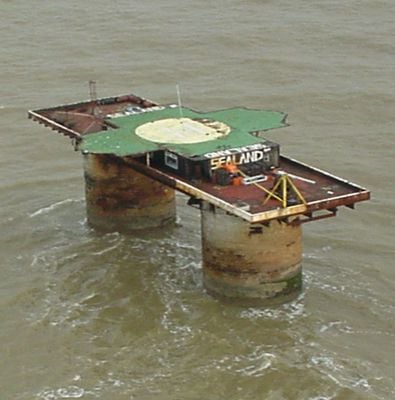
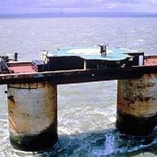
The Principality of Sealand is a former military platform made of steel and concrete rising on two hollow towers about 6 miles (10 kilometers) off the coast of Harwich in open water. The construction stands on legs roughly 60 feet (18 meters) tall and supports a deck the size of two tennis courts, surrounded by wind and waves.

The British Navy built this station in 1942 as HM Fort Roughs, an anti-aircraft position to defend the Thames Estuary against German bombers during World War II. After the war ended the military abandoned the site, which was then occupied by private individuals in 1967.

Since 1967 the platform has operated with its own flag, stamps, and titles of nobility granted to supporters worldwide. The small community considers itself an independent state and maintains ceremonies and traditions that visitors can witness during a stay.

The site lies in open water and can only be reached by boat, with crossings heavily dependent on weather and sea conditions. Anyone planning a visit should prepare for seasickness and unstable conditions, as the platform has no sheltered landing points.

A British court ruled in 1968 that the structure lies beyond national territorial waters, enabling claims of sovereignty. Since then there have been occupation attempts and even an armed incident recorded as a coup attempt in its history.

Location: Harwich

Inception: September 2, 1967

Founders: Paddy Roy Bates

Website: https://sealandgov.org

GPS coordinates: 51.89444,1.48250

Latest update: December 14, 2025 20:17

Photos
Secret military sites and underground facilities around the world

This collection brings together underground military sites, strategic bunkers, and highly secured installations across the world. Many of these places were built during the Cold War, when nuclear threats pushed governments to create protected command centers deep under mountains or in remote areas....

Reviews

Visited this place? Tap the stars to rate it and share your experience / photos with the community! Try now! You can cancel it anytime.

« Principality of Sealand - Artificial island with military platform in North Sea near Harwich, United Kingdom » is provided by Around Us (aroundus.com). Images and texts are derived from Wikimedia project under a Creative Commons license. You are allowed to copy, distribute, and modify copies of this page, under the conditions set by the license, as long as this note is clearly visible.

Discover hidden gems everywhere you go!

From secret cafés to breathtaking viewpoints, skip the crowded tourist spots and find places that match your style. Our app makes it easy with voice search, smart filtering, route optimization, and insider tips from travelers worldwide. Download now for the complete mobile experience.

Around Us App Screenshot

A unique approach to discovering new places

Le Figaro

All the places worth exploring

France Info

A tailor-made excursion in just a few clicks

20 Minutes