Chest opened
+${chestReward.xp} XP
Explorer
NOUVEAU ×${chestReward.collectible.quantity}
tapez pour fermer
Chest locked

Open chests in the app

Around Us is built for your phone — chests unlock when you walk, explore and capture nearby places.

Enable Location

We need your location to show you interesting places around you

Discover nearby places

Find interesting locations and hidden gems around you

Precise directions

Get accurate directions and distances to places

Your location is never shared with other users. It's only used when you tap the location button.

Slade Green

Log in to your account

Start exploring — it's free

Trusted by 72,891 travelers worldwide

Continue with Google
Continue with Apple
or

We will send you a code to connect

By continuing, you accept our Terms and Conditions and our Privacy Policy

Check your inbox

We've sent a pincode in your inbox. Please enter the code below.

Slade Green
Discussion Reviews 1 Photos
11.4k Popularity

Slade Green, Residential district in southeast London, England

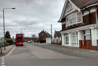
Slade Green is a residential district in the northeastern part of the London Borough of Bexley, located near the River Thames. The area developed around its railway station, which remains a central feature of the neighborhood's layout and connectivity.

The area began as a small hamlet that underwent dramatic change following the arrival of the railway in the 19th century. The rail line spurred residential growth and transformed the settlement into a railway village over subsequent decades.

Archaeological findings in the region include paleolithic fossils and flint artifacts collected by researchers such as Flaxman Charles John Spurrell.

The area is well served by trains departing from Slade Green station, which connects to central London. The station provides straightforward access to the wider transport network without requiring transfers or complicated connections.

A munitions factory operated here during World War I, making ammunition and explosives for the military. The facility came to an abrupt end in 1924 when an explosion caused significant damage.

The community of curious travelers

AroundUs brings together thousands of curated places, local tips, and hidden gems, enriched daily by 60,000 contributors worldwide.

Start exploring
Shares border with
Erith
GPS coordinates
51.46680,0.19640
Latest update
December 8, 2025 13:41
Around this place
London Outer Orbital Path
United Kingdom

London Outer Orbital Path

2.2 km
The Mick Jagger Centre
United Kingdom

The Mick Jagger Centre

2.5 km
Orchard Theatre
United Kingdom

Orchard Theatre

2.8 km
Erith Playhouse
United Kingdom

Erith Playhouse

1.9 km
Our Lady of the Angels Church, Erith
United Kingdom

Our Lady of the Angels Church, Erith

2.6 km
One Bell
United Kingdom

One Bell

2.1 km
Priory Farmhouse containing the remains of Dartford Priory Gatehouse
United Kingdom

Priory Farmhouse containing the remains of Dartford Priory Gatehouse

2.4 km
Crayford Town Hall
United Kingdom

Crayford Town Hall

2.2 km
Church of St Paulinus, Crayford
United Kingdom

Church of St Paulinus, Crayford

2 km
Christ Church
United Kingdom

Christ Church

2.4 km
Christ Church
United Kingdom

Christ Church

2 km
St Paul's
United Kingdom

St Paul's

2.6 km
Former West Hill Police Station
United Kingdom

Former West Hill Police Station

2.5 km
Erith Old Library
United Kingdom

Erith Old Library

2.1 km
Coal Duty Boundary Marker (On Foreshore, At Mouth Of River Darenth, West Bank)
United Kingdom

Coal Duty Boundary Marker (On Foreshore, At Mouth Of River Darenth, West Bank)

2.1 km
Beadles
United Kingdom

Beadles

2.8 km
Kent House  The County Court
United Kingdom

Kent House The County Court

2.7 km
Crayford War Memorial
United Kingdom

Crayford War Memorial

1.9 km
Erith (Christ Church) War Memorial
United Kingdom

Erith (Christ Church) War Memorial

2 km
The Royal Oak Public House
United Kingdom

The Royal Oak Public House

2.7 km
28 And 30, Erith High Street
United Kingdom

28 And 30, Erith High Street

1.9 km
The Long Shed (Part Of David Evans Limited Factory At Number 71)
United Kingdom

The Long Shed (Part Of David Evans Limited Factory At Number 71)

2.3 km
World War II Heavy Anti-Aircraft (Haa) Battery
United Kingdom

World War II Heavy Anti-Aircraft (Haa) Battery

944 m
Milestone Opposite Nos 179 And 179A
United Kingdom

Milestone Opposite Nos 179 And 179A

2.1 km
Remains Of Priory Walls In Victoria Road, Kingsfield Terrace And Priory Lane, Including The Doorway In Kingsfield Terrace
United Kingdom

Remains Of Priory Walls In Victoria Road, Kingsfield Terrace And Priory Lane, Including The Doorway In Kingsfield Terrace

2.3 km
Crayford Manor House
United Kingdom

Crayford Manor House

1.9 km
Lychgate to West of Parish Church of St Paulinus
United Kingdom

Lychgate to West of Parish Church of St Paulinus

2.1 km
The Oakwood
United Kingdom

The Oakwood

2.2 km
Show the full map
Reviews
Share your experience

No review yet

Discussions
Start a discussion...

No discussion yet

« Slade Green - Residential district in southeast London, England » is provided by Around Us (aroundus.com). Images and texts are derived from Wikimedia project under a Creative Commons license. You are allowed to copy, distribute, and modify copies of this page, under the conditions set by the license, as long as this note is clearly visible.

Discover hidden gems everywhere you go!

From secret cafés to breathtaking viewpoints, skip the crowded tourist spots and find places that match your style. Our app makes it easy with voice search, smart filtering, route optimization, and insider tips from travelers worldwide. Download now for the complete mobile experience.

Around Us App Screenshot

A unique approach to discovering new places

Le Figaro

All the places worth exploring

France Info

A tailor-made excursion in just a few clicks

20 Minutes

Around Us
Travel Guide & Maps
Download

Send to your phone

QR Code
1

Open the camera app on your mobile.

2

Point at the QR code with your camera. A notification will appear.

3

Tap the notification to open the link.