Enable Location

We need your location to show you interesting places around you

Discover nearby places

Find interesting locations and hidden gems around you

Precise directions

Get accurate directions and distances to places

Your location is never shared with other users. It's only used when you tap the location button.

Toms Creek Falls

Log in to your account

Start exploring — it's free

Trusted by 65,771 travelers worldwide

Continue with Google
Continue with Apple
or

We will send you a code to connect

By continuing, you accept our Terms and Conditions and our Privacy Policy

Check your inbox

We've sent a pincode in your inbox. Please enter the code below.

Toms Creek Falls
Discussion Reviews 1 Photos
3k Popularity

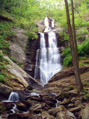
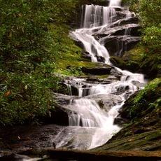
Toms Creek Falls, Cascading waterfall in Pisgah National Forest, North Carolina

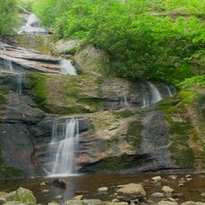
Toms Creek Falls is a tiered waterfall in Pisgah National Forest, North Carolina, where water drops roughly 80 feet (24 m) down a rocky face. Natural pools form at different levels along the descent, giving the cascade a layered appearance from top to bottom.

In the early 20th century, the land around the falls was used for mica mining, since the mineral was in demand as an industrial insulator at the time. When mining activity wound down, the area was folded into what became Pisgah National Forest.

The falls sit in a part of western North Carolina where outdoor life is deeply woven into daily routines, and locals treat this spot as a familiar place to spend a few hours. The short walk to reach it makes it a popular choice for families and solo visitors alike.

The trail to the falls is short and manageable for most visitors, with wooden viewing decks along the way that offer different angles on the water. Sturdy footwear is a good idea, as the ground near the base can be wet and slippery.

When the water level drops, flecks of mica embedded in the rocks near the base catch the light and give the stone a faint sparkle. These deposits are a direct trace of the mining operations that once shaped this part of the forest.

The community of curious travelers

AroundUs brings together thousands of curated places, local tips, and hidden gems, enriched daily by 60,000 contributors worldwide.

Start exploring
Location
GPS coordinates
35.77757,-82.06242
Latest update
March 3, 2026 13:54
Around this place
Mount Mitchell
United States of America

Mount Mitchell

18.4 km
Linville Gorge Wilderness
United States of America

Linville Gorge Wilderness

19.6 km
Mount Craig
United States of America

Mount Craig

18 km
Lake James State Park
United States of America

Lake James State Park

16.4 km
Carson House
United States of America

Carson House

9.6 km
Celo Knob
United States of America

Celo Knob

18.8 km
Roaring Fork Falls
United States of America

Roaring Fork Falls

11.8 km
Church of the Resurrection
United States of America

Church of the Resurrection

8.5 km
Joseph McDowell House
United States of America

Joseph McDowell House

11.7 km
Setrock Creek Falls
United States of America

Setrock Creek Falls

15.2 km
Main Street Historic District
United States of America

Main Street Historic District

11.4 km
United States of America

Whiteoak Creek Falls

15.2 km
Gillespie Gap
United States of America

Gillespie Gap

8.4 km
First Presbyterian Church
United States of America

First Presbyterian Church

11.3 km
St. Matthew's Lutheran Church
United States of America

St. Matthew's Lutheran Church

11.5 km
St. John's Episcopal Church
United States of America

St. John's Episcopal Church

12 km
Depot Historic District
United States of America

Depot Historic District

11.7 km
Downtown Spruce Pine Historic District
United States of America

Downtown Spruce Pine Historic District

15.4 km
Lone Beech
United States of America

Lone Beech

11.2 km
Welsford Parker Artz House
United States of America

Welsford Parker Artz House

19.4 km
Carson–Young House
United States of America

Carson–Young House

7.9 km
McDowell County Courthouse
United States of America

McDowell County Courthouse

11.5 km
Henry Seawell Brown and Mary Jane English Farmstead
United States of America

Henry Seawell Brown and Mary Jane English Farmstead

13.9 km
Mount Mitchell State Park
United States of America

Mount Mitchell State Park

18.2 km
Museum of North Carolina Minerals
United States of America

Museum of North Carolina Minerals

9 km
Mount Mitchell Museum
United States of America

Mount Mitchell Museum

18.4 km
Elisha Mitchell's tomb
United States of America

Elisha Mitchell's tomb

18.4 km
Mount Mitchell State Park Environmental Education Center
United States of America

Mount Mitchell State Park Environmental Education Center

18.3 km
Show the full map
Reviews
Share your experience

No review yet

Discussions
Start a discussion...

No discussion yet

« Toms Creek Falls - Cascading waterfall in Pisgah National Forest, North Carolina » is provided by Around Us (aroundus.com). Images and texts are derived from Wikimedia project under a Creative Commons license. You are allowed to copy, distribute, and modify copies of this page, under the conditions set by the license, as long as this note is clearly visible.

Discover hidden gems everywhere you go!

From secret cafés to breathtaking viewpoints, skip the crowded tourist spots and find places that match your style. Our app makes it easy with voice search, smart filtering, route optimization, and insider tips from travelers worldwide. Download now for the complete mobile experience.

Around Us App Screenshot

A unique approach to discovering new places

Le Figaro

All the places worth exploring

France Info

A tailor-made excursion in just a few clicks

20 Minutes

Around Us
Travel Guide & Maps
Download

Send to your phone

QR Code
1

Open the camera app on your mobile.

2

Point at the QR code with your camera. A notification will appear.

3

Tap the notification to open the link.