Enable Location

We need your location to show you interesting places around you

Discover nearby places

Find interesting locations and hidden gems around you

Precise directions

Get accurate directions and distances to places

Your location is never shared with other users. It's only used when you tap the location button.

Lake James State Park

Log in to your account

Start exploring — it's free

Trusted by 65,784 travelers worldwide

Continue with Google
Continue with Apple
or

We will send you a code to connect

By continuing, you accept our Terms and Conditions and our Privacy Policy

Check your inbox

We've sent a pincode in your inbox. Please enter the code below.

Lake James State Park
Discussion Reviews 1 Photos
5.1k Popularity

Lake James State Park, State park in Burke and McDowell counties, North Carolina.

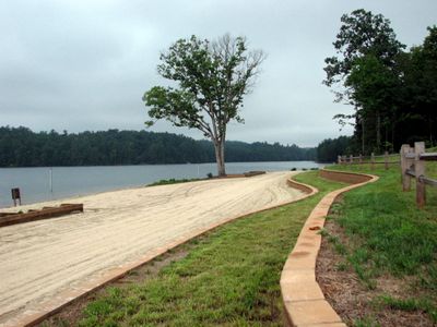
Lake James State Park is a nature reserve in the foothills of the Appalachian Mountains, straddling Burke and McDowell counties in North Carolina. The lake at its center offers access to hiking trails, swimming, and boating from several points along the shoreline.

The land around Lake James was known to mountain communities long before the state park was formally established in the 1980s. The lake itself was created earlier in the 20th century when a dam was built across the Catawba River to generate hydroelectric power.

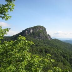
The lake attracts a mix of local fishers and families who spend weekends exploring the water and trails throughout the seasons. People gather here to experience the mountains and connect with the outdoor rhythm of the Piedmont and Blue Ridge area.

The park has several separate access points, so it helps to check in advance which area best suits the activity you have in mind, whether that is hiking, swimming, or boating. Sturdy footwear and a layer for sudden weather changes are worth bringing, as conditions in the mountain foothills can shift quickly.

Several campsites along the shoreline can only be reached by boat, making them genuinely remote in a way that most park campgrounds are not. Booking one of these spots in advance is the only way to secure a night out on the water with no road access nearby.

The community of curious travelers

AroundUs brings together thousands of curated places, local tips, and hidden gems, enriched daily by 60,000 contributors worldwide.

Start exploring
Location
Inception
1987
GPS coordinates
35.73390,-81.88920
Latest update
March 3, 2026 08:15
Around this place
United States of America

Joara

17 km
United States of America

Fort San Juan

17.3 km
Table Rock
United States of America

Table Rock

17.5 km
Carson House
United States of America

Carson House

15.9 km
Toms Creek Falls
United States of America

Toms Creek Falls

16.4 km
Quaker Meadows
United States of America

Quaker Meadows

15.4 km
Joseph McDowell House
United States of America

Joseph McDowell House

12 km
Creekside
United States of America

Creekside

16.3 km
Magnolia Place
United States of America

Magnolia Place

17.7 km
Franklin Pierce Tate House
United States of America

Franklin Pierce Tate House

17.6 km
Main Street Historic District
United States of America

Main Street Historic District

12.2 km
Tate House
United States of America

Tate House

18.1 km
Bellevue
United States of America

Bellevue

17.1 km
First Presbyterian Church
United States of America

First Presbyterian Church

12.5 km
St. Matthew's Lutheran Church
United States of America

St. Matthew's Lutheran Church

12.6 km
St. John's Episcopal Church
United States of America

St. John's Episcopal Church

12.2 km
Mountain View
United States of America

Mountain View

17.4 km
Depot Historic District
United States of America

Depot Historic District

12.4 km
Gaither House
United States of America

Gaither House

17.8 km
John Alexander Lackey House
United States of America

John Alexander Lackey House

15.9 km
Alphonse Calhoun Avery House
United States of America

Alphonse Calhoun Avery House

17.8 km
Lone Beech
United States of America

Lone Beech

12.4 km
Gilboa Methodist Church
United States of America

Gilboa Methodist Church

15.3 km
Dr. Joseph Bennett Riddle House
United States of America

Dr. Joseph Bennett Riddle House

17.7 km
Carson–Young House
United States of America

Carson–Young House

15.2 km
Jacob Forney Jr. House
United States of America

Jacob Forney Jr. House

17 km
McDowell County Courthouse
United States of America

McDowell County Courthouse

12.2 km
Henry Seawell Brown and Mary Jane English Farmstead
United States of America

Henry Seawell Brown and Mary Jane English Farmstead

15.8 km
Show the full map
Reviews
Share your experience

No review yet

Discussions
Start a discussion...

No discussion yet

« Lake James State Park - State park in Burke and McDowell counties, North Carolina » is provided by Around Us (aroundus.com). Images and texts are derived from Wikimedia project under a Creative Commons license. You are allowed to copy, distribute, and modify copies of this page, under the conditions set by the license, as long as this note is clearly visible.

Discover hidden gems everywhere you go!

From secret cafés to breathtaking viewpoints, skip the crowded tourist spots and find places that match your style. Our app makes it easy with voice search, smart filtering, route optimization, and insider tips from travelers worldwide. Download now for the complete mobile experience.

Around Us App Screenshot

A unique approach to discovering new places

Le Figaro

All the places worth exploring

France Info

A tailor-made excursion in just a few clicks

20 Minutes

Around Us
Travel Guide & Maps
Download

Send to your phone

QR Code
1

Open the camera app on your mobile.

2

Point at the QR code with your camera. A notification will appear.

3

Tap the notification to open the link.