Enable Location

We need your location to show you interesting places around you

Discover nearby places

Find interesting locations and hidden gems around you

Precise directions

Get accurate directions and distances to places

Your location is never shared with other users. It's only used when you tap the location button.

Table Rock

Log in to your account

Start exploring — it's free

Trusted by 64,825 travelers worldwide

Continue with Google
Continue with Apple
or

We will send you a code to connect

By continuing, you accept our Terms and Conditions and our Privacy Policy

Check your inbox

We've sent a pincode in your inbox. Please enter the code below.

Table Rock
Discussion Reviews 1 Photos
8.2k Popularity

Table Rock, Mountain summit in Burke County, United States.

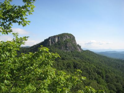
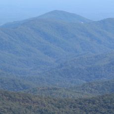
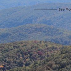
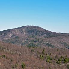
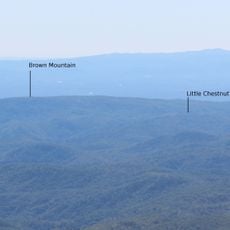
Table Rock is a mountain summit in Burke County, North Carolina, sitting within the Pisgah National Forest and recognizable by its distinctively flat top. The peak is made up of several natural rock platforms that give it its name and make it visible from many points across the state.

Indigenous peoples lived in this region long before European settlers arrived in the 18th century, and the mountain was part of the land they knew and used. Over time, the surrounding area was incorporated into the Pisgah National Forest, which now protects this land.

Table Rock draws climbers from across the region who come to practice on its rock faces and share techniques with one another. The flat summit also attracts hikers who simply want to stand above the surrounding ridges and take in the open sky.

The access road closes from January through March, so plan your visit for another time of year. Good walking shoes and enough water are strongly recommended for the hike to the top.

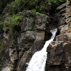
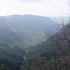
From the flat top, you can look directly down into Linville Gorge, one of the deepest canyons in the eastern United States. This view into the gorge is accessible from the edge of the rock platforms without any special equipment.

The community of curious travelers

AroundUs brings together thousands of curated places, local tips, and hidden gems, enriched daily by 60,000 contributors worldwide.

Start exploring
Location
GPS coordinates
35.89096,-81.88289
Latest update
March 3, 2026 08:20
Around this place
Linville Falls
United States of America

Linville Falls

7.7 km
Linville Gorge Wilderness
United States of America

Linville Gorge Wilderness

3.3 km
United States of America

Joara

18.3 km
United States of America

Fort San Juan

15.4 km
Lake James State Park
United States of America

Lake James State Park

17.5 km
Toms Creek Falls
United States of America

Toms Creek Falls

20.5 km
Church of the Resurrection
United States of America

Church of the Resurrection

19.3 km
Quaker Meadows
United States of America

Quaker Meadows

20.9 km
Tuttle Educational State Forest
United States of America

Tuttle Educational State Forest

22.5 km
Adams Mountain
United States of America

Adams Mountain

14.9 km
Bee Mountain
United States of America

Bee Mountain

16.5 km
Nuckolls-Jefferies House
United States of America

Nuckolls-Jefferies House

20.5 km
Chestnut Mountain
United States of America

Chestnut Mountain

10.4 km
Bellevue
United States of America

Bellevue

19.8 km
Gillespie Gap
United States of America

Gillespie Gap

15.7 km
Mulberry Chapel Methodist Church
United States of America

Mulberry Chapel Methodist Church

21.1 km
John Alexander Lackey House
United States of America

John Alexander Lackey House

20.2 km
Little Chestnut Mountain
United States of America

Little Chestnut Mountain

11.1 km
Downtown Spruce Pine Historic District
United States of America

Downtown Spruce Pine Historic District

17.1 km
Ray Wiseman House
United States of America

Ray Wiseman House

12.6 km
Milligan Shuford Wise and Theron Colbert Dellinger Houses
United States of America

Milligan Shuford Wise and Theron Colbert Dellinger Houses

15 km
Jacob Forney Jr. House
United States of America

Jacob Forney Jr. House

17.9 km
Franklin-Penland House
United States of America

Franklin-Penland House

8.4 km
Henry Seawell Brown and Mary Jane English Farmstead
United States of America

Henry Seawell Brown and Mary Jane English Farmstead

7 km
Sloan-Throneburg Farm
United States of America

Sloan-Throneburg Farm

21 km
Museum of North Carolina Minerals
United States of America

Museum of North Carolina Minerals

15.8 km
Linville Falls Visitor Center
United States of America

Linville Falls Visitor Center

8.2 km
Blue Ridge Parkway North Carolina 181 Bridge
United States of America

Blue Ridge Parkway North Carolina 181 Bridge

12.7 km
Show the full map
Reviews
Share your experience

No review yet

Discussions
Start a discussion...

No discussion yet

« Table Rock - Mountain summit in Burke County, United States » is provided by Around Us (aroundus.com). Images and texts are derived from Wikimedia project under a Creative Commons license. You are allowed to copy, distribute, and modify copies of this page, under the conditions set by the license, as long as this note is clearly visible.

Discover hidden gems everywhere you go!

From secret cafés to breathtaking viewpoints, skip the crowded tourist spots and find places that match your style. Our app makes it easy with voice search, smart filtering, route optimization, and insider tips from travelers worldwide. Download now for the complete mobile experience.

Around Us App Screenshot

A unique approach to discovering new places

Le Figaro

All the places worth exploring

France Info

A tailor-made excursion in just a few clicks

20 Minutes

Around Us
Travel Guide & Maps
Download

Send to your phone

QR Code
1

Open the camera app on your mobile.

2

Point at the QR code with your camera. A notification will appear.

3

Tap the notification to open the link.