Enable Location

We need your location to show you interesting places around you

Discover nearby places

Find interesting locations and hidden gems around you

Precise directions

Get accurate directions and distances to places

Your location is never shared with other users. It's only used when you tap the location button.

KXJB-TV mast

Log in to your account

Start exploring — it's free

Trusted by 61,351 travelers worldwide

Continue with Google
Continue with Apple
or

We will send you a code to connect

By continuing, you accept our Terms and Conditions and our Privacy Policy

Check your inbox

We've sent a pincode in your inbox. Please enter the code below.

KXJB-TV mast

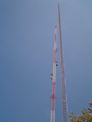
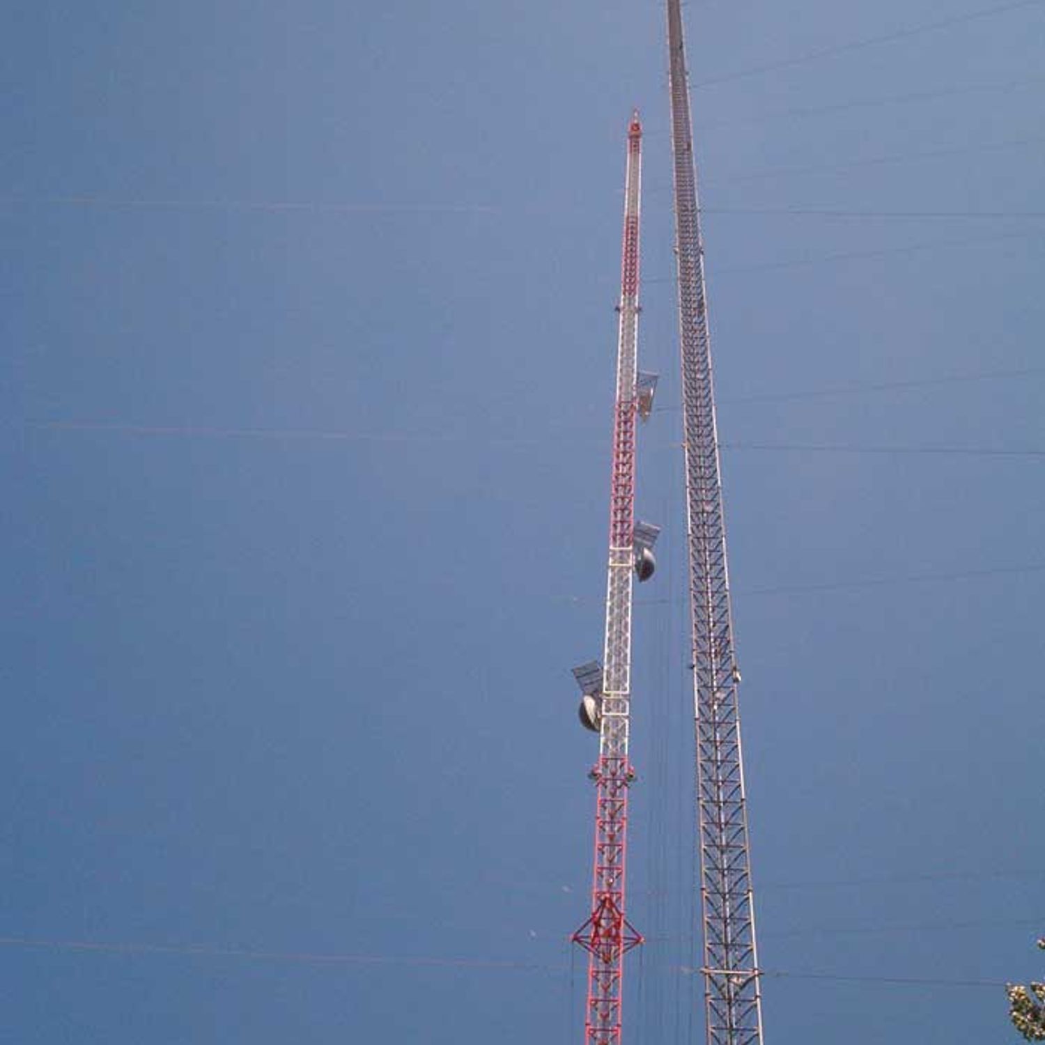
KXJB-TV mast, Television transmitting tower in Traill County, United States

Description

KXJB-TV mast is a television transmitting tower in Traill County, North Dakota, that reaches a remarkable height and ranks among the tallest structures on the American continent. The structure requires a large area of land for its anchoring system and broadcasts television signals across wide distances to serve regional audiences.

History

The tower was built to broadcast television signals across the region, and has experienced two major structural failures during its history. A helicopter incident damaged its supporting cables, and an ice storm later caused significant damage to the structure.

Culture

The tower stands as a visual landmark that people across the region recognize and use for orientation in the landscape. It has become an ordinary part of the view for those living in the area, shaping how they see their surroundings.

Practical

The site is located several kilometers northeast of Galesburg and is clearly visible from nearby roads. Visitors should be aware that the area immediately around the tower is restricted for safety reasons and the supporting cable system extends across a large area that must be respected.

Did you know?

The tower contains a small elevator designed for two people that carries maintenance workers to service the structure regularly. This operating system is an overlooked detail that demonstrates the practical challenges of maintaining such a tall structure.

Location
GPS coordinates
47.27917,-97.34083
Latest update
December 7, 2025 10:07

AroundUs brings together thousands of curated places, local tips, and hidden gems, enriched daily by 60,000 contributors worldwide. Discover all places nearby (Traill County).

Around this place
Fargodome
United States of America

Fargodome

58.5 km
Red River Zoo
United States of America

Red River Zoo

60.8 km
Bonanzaville, USA
United States of America

Bonanzaville, USA

54.7 km
Fargo Air Museum
United States of America

Fargo Air Museum

58.2 km
The Roger Maris Museum
United States of America

The Roger Maris Museum

60 km
Carl Ben Eielson House
United States of America

Carl Ben Eielson House

40.8 km
North Dakota State University District
United States of America

North Dakota State University District

59.4 km
St. Stephen's Episcopal Church
United States of America

St. Stephen's Episcopal Church

43.1 km
Delchar Theatre
United States of America

Delchar Theatre

24.6 km
Old Stone Church
United States of America

Old Stone Church

42.9 km
United States of America

Woodrow Wilson School

60.6 km
Zion Lutheran Church
United States of America

Zion Lutheran Church

46 km
James Holes House
United States of America

James Holes House

60.3 km
Great Northern Freight Warehouse
United States of America

Great Northern Freight Warehouse

60.8 km
Goose River Bank
United States of America

Goose River Bank

24.6 km
Caledonia Bridge
United States of America

Caledonia Bridge

39.7 km
Traill County Courthouse
United States of America

Traill County Courthouse

25.1 km
First State Bank of Buxton
United States of America

First State Bank of Buxton

40.4 km
Casselton Commercial Historic District
United States of America

Casselton Commercial Historic District

43.3 km
Col. William H. Robinson House
United States of America

Col. William H. Robinson House

25 km
Amos and Lillie Plummer House
United States of America

Amos and Lillie Plummer House

24.9 km
Blanchard Bridge
United States of America

Blanchard Bridge

11.5 km
First National Bank
United States of America

First National Bank

24.6 km
Stomner House
United States of America

Stomner House

24.8 km
Sheyenne River Bridge
United States of America

Sheyenne River Bridge

50.6 km
Steele County Courthouse
United States of America

Steele County Courthouse

45.7 km
Mayville Public Library
United States of America

Mayville Public Library

24.7 km
John Olness House
United States of America

John Olness House

54.9 km
Show the full map
« KXJB-TV mast - Television transmitting tower in Traill County, United States » is provided by Around Us (aroundus.com). Images and texts are derived from Wikimedia project under a Creative Commons license. You are allowed to copy, distribute, and modify copies of this page, under the conditions set by the license, as long as this note is clearly visible.

Discover hidden gems everywhere you go!

From secret cafés to breathtaking viewpoints, skip the crowded tourist spots and find places that match your style. Our app makes it easy with voice search, smart filtering, route optimization, and insider tips from travelers worldwide. Download now for the complete mobile experience.

Around Us App Screenshot

A unique approach to discovering new places

Le Figaro

All the places worth exploring

France Info

A tailor-made excursion in just a few clicks

20 Minutes

Around Us
Travel Guide & Maps
Download

Send to your phone

QR Code
1

Open the camera app on your mobile.

2

Point at the QR code with your camera. A notification will appear.

3

Tap the notification to open the link.