Chase County

Log in to your account

AroundUs is a community-driven map of interesting places, built by curious explorers like you. It grows with every review, story, and photo you share.
Connect to save your favorite spots, contribute locations, and create personalized routes.
Continue with Google
Continue with Apple
Continue with X
Continue with Facebook
Continue with email
By continuing, you accept our Terms and Conditions and our Privacy Policy
Create an account
Add to collection
Map
Suggest a change
Share

Chase County, Administrative county in eastern Kansas, United States

Chase County is an administrative division in eastern Kansas that encompasses nine townships and several small communities spread across the landscape. Major roads including U.S. Route 50, Kansas Highways 150 and 177, and Interstate 35 connect the region to surrounding areas.

The county took its name from Salmon Portland Chase, a prominent political figure who served as Ohio's governor, a U.S. Senator, Treasury Secretary, and Chief Justice of the Supreme Court. His prominence in American government reflected the settlers' aspirations for the region they were building.

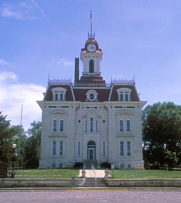
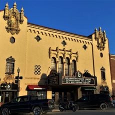
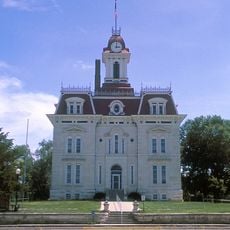
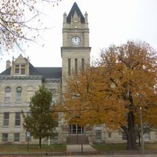
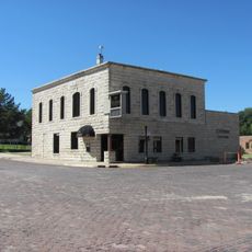
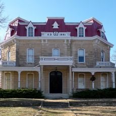
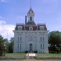
The courthouse in Cottonwood Falls anchors community life with its French Renaissance architecture and limestone walls, where residents gather for local events and celebrations. The building reflects how settlers valued permanence and civic pride when establishing their towns.

Visitors should plan to travel by car, as the region is served by several highways connecting to neighboring areas. The warmer months offer the best conditions for exploring the townships and communities throughout the county.

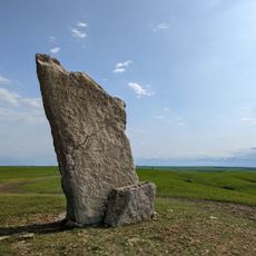
The Tallgrass Prairie National Preserve protects one of the last intact sections of North American prairie with native plants and wildlife still thriving there. This landscape reveals what the region looked like before settlement and farming transformed it.

Location: Kansas

Inception: February 11, 1859

Capital city: Cottonwood Falls

Shares border with: Morris County, Lyon County, Greenwood County, Butler County, Marion County

Website: http://chasecountychamber.org

GPS coordinates: 38.30000,-96.58330

Latest update: December 7, 2025 20:43

Photos
Around this place
National Teachers Hall of Fame
United States of America

National Teachers Hall of Fame

37.5 km
Welch Stadium
United States of America

Welch Stadium

37.6 km
Harvey House
United States of America

Harvey House

30.9 km
Emporia Granada Theatre
United States of America

Emporia Granada Theatre

37.2 km
Chase County Courthouse
United States of America

Chase County Courthouse

8.9 km
Lower Fox Creek School
United States of America

Lower Fox Creek School

15.8 km
Clements Stone Arch Bridge
United States of America

Clements Stone Arch Bridge

13.2 km
Cottonwood River Pratt Truss Bridge
United States of America

Cottonwood River Pratt Truss Bridge

22.3 km
Whitney Ranch
United States of America

Whitney Ranch

21.7 km
Crocker Ranch
United States of America

Crocker Ranch

13.2 km
Burns Union School
United States of America

Burns Union School

35.5 km
Dunlap Colored Cemetery
United States of America

Dunlap Colored Cemetery

37.7 km
Clover Cliff Ranch House
United States of America

Clover Cliff Ranch House

10.5 km
St. Andrew's Episcopal Church
United States of America

St. Andrew's Episcopal Church

37.2 km
Cottonwood River Bridge
United States of America

Cottonwood River Bridge

9.1 km
Walt Mason House
United States of America

Walt Mason House

36.6 km
Marion County Courthouse
United States of America

Marion County Courthouse

38.4 km
Richard Howe House
United States of America

Richard Howe House

37.1 km
Fox Creek Stone Arch Bridge
United States of America

Fox Creek Stone Arch Bridge

11.8 km
Wood House
United States of America

Wood House

9.6 km
Chase County National Bank
United States of America

Chase County National Bank

8.8 km
Cottonwood Falls Grade School
United States of America

Cottonwood Falls Grade School

8.1 km
William C. & Jane Shaft House
United States of America

William C. & Jane Shaft House

13.2 km
Teter Rock
United States of America

Teter Rock

33.2 km
Spring Hill Farm and Stock Ranch House
United States of America

Spring Hill Farm and Stock Ranch House

15.1 km
Harris Bridge
United States of America

Harris Bridge

35.2 km
Soden's Grove Bridge
United States of America

Soden's Grove Bridge

36.3 km
Whitney Ranch - House
United States of America

Whitney Ranch - House

21.7 km
Show the full map
Reviews

Visited this place? Tap the stars to rate it and share your experience / photos with the community! Try now! You can cancel it anytime.

Administrative divisions
« Chase County - Administrative county in eastern Kansas, United States » is provided by Around Us (aroundus.com). Images and texts are derived from Wikimedia project under a Creative Commons license. You are allowed to copy, distribute, and modify copies of this page, under the conditions set by the license, as long as this note is clearly visible.

Discover hidden gems everywhere you go!

From secret cafés to breathtaking viewpoints, skip the crowded tourist spots and find places that match your style. Our app makes it easy with voice search, smart filtering, route optimization, and insider tips from travelers worldwide. Download now for the complete mobile experience.

Around Us App Screenshot

A unique approach to discovering new places

Le Figaro

All the places worth exploring

France Info

A tailor-made excursion in just a few clicks

20 Minutes