Gadsden County

Log in to your account

AroundUs is a community-driven map of interesting places, built by curious explorers like you. It grows with every review, story, and photo you share.
Connect to save your favorite spots, contribute locations, and create personalized routes.
Continue with Google
Continue with Apple
Continue with X
Continue with Facebook
Continue with email
By continuing, you accept our Terms and Conditions and our Privacy Policy
Create an account
Add to collection
Map
Suggest a change
Share

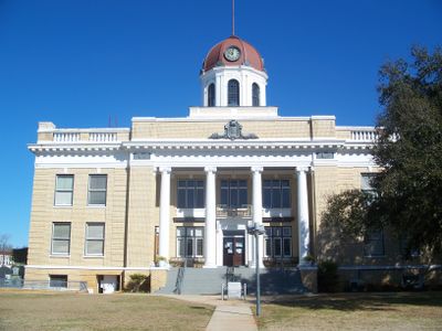
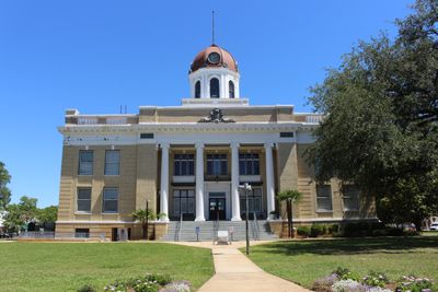
Gadsden County, County seat in Florida panhandle, United States.

Gadsden County is a county in north-central Florida that combines farmland, small towns, and villages across its landscape, with Quincy serving as the main administrative hub. The area includes several interconnected communities with local shops, schools, and services distributed throughout.

The county was established in 1832 during the early American settlement of north Florida and named after James Gadsden, a military officer important to the region's development. Its founding marked the beginning of American territorial organization in this part of the state.

The county is Florida's only majority African-American region, and this heritage shapes local traditions, music, art, and community gatherings you encounter throughout the area. Walking through towns and villages, you notice how this cultural identity influences daily life and the character of neighborhoods.

Interstate 10 and US Highway 90 run through the county and connect its communities for driving. Local bus services offer some transportation options, though having a car makes getting around much easier for most activities.

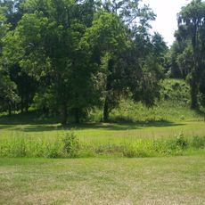
The region was once a major tobacco growing area, and farming operations shaped the local economy across multiple generations and left their mark on the landscape. You can still see traces of this agricultural past in older farm structures and land patterns.

Location: Florida

Inception: June 24, 1832

Capital city: Quincy

Reference: 12-039

Shares border with: Decatur County, Seminole County, Grady County, Leon County, Liberty County, Calhoun County, Jackson County

Website: http://gadsdengov.net

GPS coordinates: 30.58000,-84.61000

Latest update: December 19, 2025 22:46

Photos
Around this place
Doak Campbell Stadium
United States of America

Doak Campbell Stadium

33.3 km
Donald L. Tucker Center
United States of America

Donald L. Tucker Center

34.8 km
Lake Jackson Mounds Archaeological State Park
United States of America

Lake Jackson Mounds Archaeological State Park

29.8 km
Bragg Memorial Stadium
United States of America

Bragg Memorial Stadium

35 km
FSU Flying High Circus
United States of America

FSU Flying High Circus

33.3 km
Lewis House
United States of America

Lewis House

30.2 km
Tallahassee Museum
United States of America

Tallahassee Museum

31.7 km
Jim Woodruff Dam
United States of America

Jim Woodruff Dam

28.2 km
R.A. Gray Florida History Museum
United States of America

R.A. Gray Florida History Museum

34.9 km
Westcott Building
United States of America

Westcott Building

34.2 km
Carnegie Library at FAMU
United States of America

Carnegie Library at FAMU

35.4 km
State Library and Archives of Florida
United States of America

State Library and Archives of Florida

34.9 km
Tallahassee Museum Visitor Center
United States of America

Tallahassee Museum Visitor Center

31.7 km
Bellevue Plantation
United States of America

Bellevue Plantation

31.5 km
Lichgate on High Road
United States of America

Lichgate on High Road

31.5 km
Ralph D. Turlington Florida Education Center
United States of America

Ralph D. Turlington Florida Education Center

35.1 km
United States of America

Victory Bridge

27.4 km
Leaf Theater
United States of America

Leaf Theater

3.5 km
United States of America

Park Avenue Historic District

34.9 km
United States of America

Lake Talquin State Forest

24.1 km
The Mary Brogan Museum of Art and Science
United States of America

The Mary Brogan Museum of Art and Science

35.1 km
Blackwood-Harwood Plantations Cemetery
United States of America

Blackwood-Harwood Plantations Cemetery

27 km
Fun Station
United States of America

Fun Station

32.2 km
Tookes House
United States of America

Tookes House

34.5 km
United States of America

Mina Jo Powell Alumni Green

34.2 km
Gadsden Confederate Memorial
United States of America

Gadsden Confederate Memorial

3.4 km
Quincy Library
United States of America

Quincy Library

3.4 km
Greene-Lewis House
United States of America

Greene-Lewis House

34.4 km
Show the full map
Reviews

Visited this place? Tap the stars to rate it and share your experience / photos with the community! Try now! You can cancel it anytime.

Administrative divisions
« Gadsden County - County seat in Florida panhandle, United States » is provided by Around Us (aroundus.com). Images and texts are derived from Wikimedia project under a Creative Commons license. You are allowed to copy, distribute, and modify copies of this page, under the conditions set by the license, as long as this note is clearly visible.

Discover hidden gems everywhere you go!

From secret cafés to breathtaking viewpoints, skip the crowded tourist spots and find places that match your style. Our app makes it easy with voice search, smart filtering, route optimization, and insider tips from travelers worldwide. Download now for the complete mobile experience.

Around Us App Screenshot

A unique approach to discovering new places

Le Figaro

All the places worth exploring

France Info

A tailor-made excursion in just a few clicks

20 Minutes