Enable Location

We need your location to show you interesting places around you

Discover nearby places

Find interesting locations and hidden gems around you

Precise directions

Get accurate directions and distances to places

Your location is never shared with other users. It's only used when you tap the location button.

Manatí

Log in to your account

Start exploring — it's free

Trusted by 61,921 travelers worldwide

Continue with Google
Continue with Apple
or

We will send you a code to connect

By continuing, you accept our Terms and Conditions and our Privacy Policy

Check your inbox

We've sent a pincode in your inbox. Please enter the code below.

Manatí, Coastal municipality in northern Puerto Rico.

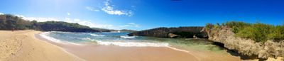
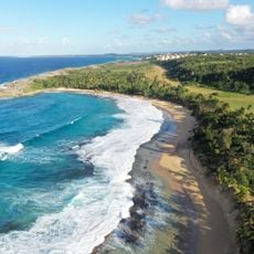
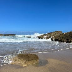
Manatí is a coastal municipality in northern Puerto Rico where limestone formations and dense vegetation define the landscape. The terrain slopes gently toward the shore, where white stone outcroppings create striking geological features.

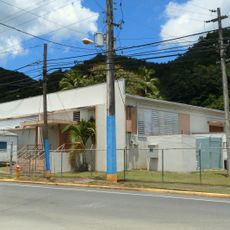
The municipality was established in 1738 by Pedro Menéndez Valdéz as the ninth officially recognized settlement under Spanish rule in Puerto Rico. Early development centered on farming and sugar production, which shaped the local economy for centuries.

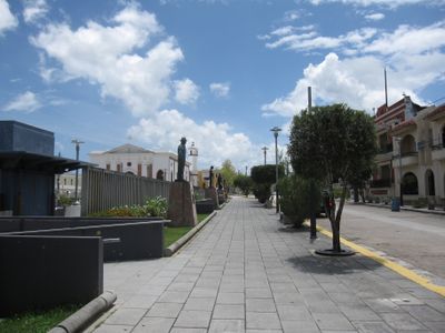
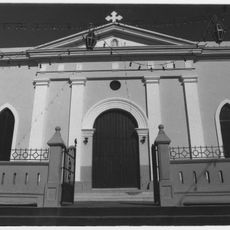
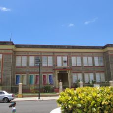
The Iglesia Nuestra Señora de la Candelaria anchors the town center with colonial-era architecture and serves as a gathering place for residents. The building reflects how Spanish settlement shaped the local community's identity and daily life.

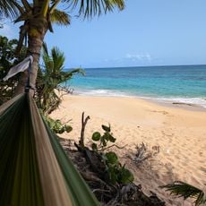
The town sits about 40 minutes from San Juan, making it accessible from the capital for day trips. Mar Chiquita beach offers a protected swimming area where limestone formations create natural coves perfect for exploring.

Hacienda La Esperanza nature reserve preserves a former sugar plantation with vintage machinery and exhibits about the region's sugar production past. The site offers visitors a chance to see tools and buildings from an era when sugar dominated the local economy.

The community of curious travelers

AroundUs brings together thousands of curated places, local tips, and hidden gems, enriched daily by 60,000 contributors worldwide.

Start exploring
Location
Inception
1738
Capital city
Manatí
Elevation above the sea
83 m
Shares border with
Morovis, Ciales, Florida, Vega Baja, Barceloneta
GPS coordinates
18.43250,-66.48444
Latest update
December 23, 2025 02:39
Around this place
Playa Mar Chiquita
United States of America

Playa Mar Chiquita

4.4 km
Nuestra Señora de la Candelaria y San Matías Church
United States of America

Nuestra Señora de la Candelaria y San Matías Church

928 m
United States of America

Cuevas Las Cabachuelas

10 km
Manatí Bridge at Mata de Plátano
United States of America

Manatí Bridge at Mata de Plátano

8 km
Casa Alonso
United States of America

Casa Alonso

10.5 km
Rafael Balseiro Maceira School
United States of America

Rafael Balseiro Maceira School

6.2 km
United States of America

Panteón Otero-Martínez

9.8 km
Playa Las Palmas
United States of America

Playa Las Palmas

5.1 km
United States of America

Teatro Fenix

10.3 km
United States of America

Teatro America

10.3 km
Playa Tortuguero
United States of America

Playa Tortuguero

4.9 km
La Poza de las Mujeres
United States of America

La Poza de las Mujeres

5.5 km

Teatro Borinquen

712 m
United States of America

Playa Mar Chiquita

4.4 km
United States of America

Puente Ing. Juan José Jiménez / Mata de Plátano (Nº 321)

8.2 km
United States of America

Teatro Taboas

950 m
United States of America

Hacienda La Esperanza

5.9 km
De Luxe Florida
United States of America

De Luxe Florida

11 km

Playa La Esperanza

7.2 km

Teatro Efraín "Pan Doblao" Berríos

11.7 km
Place des Halles
United States of America

Place des Halles

8 km
United States of America

Letras de Barceloneta

9.5 km
United States of America

La Silla Grande de Barceloneta

5.7 km
United States of America

Letras de Ciales

7.4 km
United States of America

Escultura a Raúl "Tinajón" Feliciano

10.2 km
United States of America

Escultura a Antonio Vélez Alvarado

1 km
United States of America

Estatua de Sixto Escobar Vargas

5.9 km

Paseo Líneal Juan Antonio Corretjer

8.9 km
Show the full map
« Manatí - Coastal municipality in northern Puerto Rico » is provided by Around Us (aroundus.com). Images and texts are derived from Wikimedia project under a Creative Commons license. You are allowed to copy, distribute, and modify copies of this page, under the conditions set by the license, as long as this note is clearly visible.

Discover hidden gems everywhere you go!

From secret cafés to breathtaking viewpoints, skip the crowded tourist spots and find places that match your style. Our app makes it easy with voice search, smart filtering, route optimization, and insider tips from travelers worldwide. Download now for the complete mobile experience.

Around Us App Screenshot

A unique approach to discovering new places

Le Figaro

All the places worth exploring

France Info

A tailor-made excursion in just a few clicks

20 Minutes

Around Us
Travel Guide & Maps
Download

Send to your phone

QR Code
1

Open the camera app on your mobile.

2

Point at the QR code with your camera. A notification will appear.

3

Tap the notification to open the link.