Bartlesville

Log in to your account

AroundUs is a community-driven map of interesting places, built by curious explorers like you. It grows with every review, story, and photo you share.
Connect to save your favorite spots, contribute locations, and create personalized routes.
By continuing, you accept our Terms and Conditions and our Privacy Policy
Add to collection
Map
Suggest a change
Share

Bartlesville, County seat in northeastern Oklahoma, United States.

Bartlesville is a county seat in northeastern Oklahoma, United States, covering roughly 54 square kilometers and crossed by the Caney River. The river separates the downtown core from the eastern residential neighborhoods, shaping how the city is laid out.

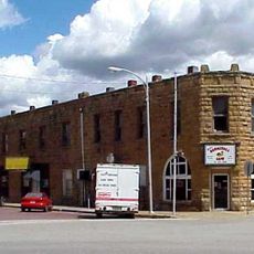
Jacob Bartles founded a trading post here in 1874, leading to official incorporation in 1897. The same year saw the drilling of Oklahoma's first commercial oil well nearby, launching the city's economic rise.

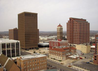
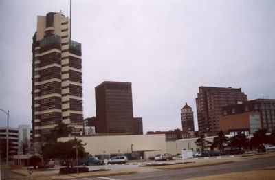
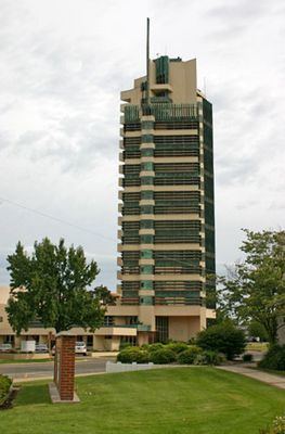
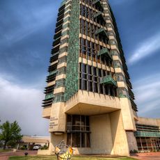
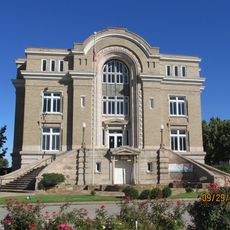
The Price Tower downtown hosts an arts center and hotel where visitors can explore galleries and public spaces inside the building. The tower's architecture continues to draw professionals and curious travelers wanting to experience the architect's only realized high-rise project.

The city sits on US Highways 60 and 75, offering direct connections in multiple directions. Jefferson Lines serves the city with intercity bus links to other towns across the region.

The Nellie Johnstone Number One marks the spot where Oklahoma's first commercial oil well was drilled in 1897, sparking an entire industry. Today a replica of the original drilling site stands as a reminder of that early resource extraction moment.

Location: Washington County

Elevation above the sea: 215 m

Website: http://cityofbartlesville.org

GPS coordinates: 36.74722,-95.95944

Latest update: December 4, 2025 23:43

Photos
Around this place
Show the full map
Price Tower
United States of America

Price Tower

1.5 km
Tallgrass Prairie Preserve
United States of America

Tallgrass Prairie Preserve

42.3 km
Woolaroc
United States of America

Woolaroc

16.3 km
Fred and Adeline Drummond House
United States of America

Fred and Adeline Drummond House

53.4 km
J. M. Davis Arms and Historical Museum
United States of America

J. M. Davis Arms and Historical Museum

57.1 km
Osage Hills State Park
United States of America

Osage Hills State Park

19.7 km
Dog Iron Ranch
United States of America

Dog Iron Ranch

41.1 km
Hulah Lake
United States of America

Hulah Lake

24 km
LaQuinta
United States of America

LaQuinta

3.3 km
Bank of Bigheart
United States of America

Bank of Bigheart

27.4 km
Diamond Point School
United States of America

Diamond Point School

23.3 km
Bank of Hominy
United States of America

Bank of Hominy

53.6 km
Onion Creek Bridge (Coffeyville, Kansas)
United States of America

Onion Creek Bridge (Coffeyville, Kansas)

41.1 km
Old Washington County Courthouse
United States of America

Old Washington County Courthouse

1.1 km
Kiddie Park
United States of America

Kiddie Park

1.6 km
Hominy School
United States of America

Hominy School

53.5 km
Hominy Armory
United States of America

Hominy Armory

53.6 km
Bethel African Methodist Episcopal Church
United States of America

Bethel African Methodist Episcopal Church

44 km
Hominy Osage Round House
United States of America

Hominy Osage Round House

53.4 km
City Hall
United States of America

City Hall

35.3 km
Niotaze Methodist Episcopal Church
United States of America

Niotaze Methodist Episcopal Church

36.3 km
Coffeyville Carnegie Public Library Building
United States of America

Coffeyville Carnegie Public Library Building

43.9 km
Little House On The Prairie Museum
United States of America

Little House On The Prairie Museum

43.4 km
Cedar Creek Bridge
United States of America

Cedar Creek Bridge

39.3 km
Claremore Auto Dealership
United States of America

Claremore Auto Dealership

57.2 km
Tall Chief Cove Beach
United States of America

Tall Chief Cove Beach

49.1 km
Drummond House
United States of America

Drummond House

53.4 km
Pryor Creek Bridge
United States of America

Pryor Creek Bridge

53.9 km
Show the full map
Reviews

Visited this place? Tap the stars to rate it and share your experience / photos with the community! Try now! You can cancel it anytime.

« Bartlesville - County seat in northeastern Oklahoma, United States » is provided by Around Us (aroundus.com). Images and texts are derived from Wikimedia project under a Creative Commons license. You are allowed to copy, distribute, and modify copies of this page, under the conditions set by the license, as long as this note is clearly visible.

Discover hidden gems everywhere you go!

From secret cafés to breathtaking viewpoints, skip the crowded tourist spots and find places that match your style. Our app makes it easy with voice search, smart filtering, route optimization, and insider tips from travelers worldwide. Download now for the complete mobile experience.

Around Us App Screenshot

A unique approach to discovering new places

Le Figaro

All the places worth exploring

France Info

A tailor-made excursion in just a few clicks

20 Minutes