Enable Location

We need your location to show you interesting places around you

Discover nearby places

Find interesting locations and hidden gems around you

Precise directions

Get accurate directions and distances to places

Your location is never shared with other users. It's only used when you tap the location button.

Osage Hills State Park

Log in to your account

Start exploring — it's free

Trusted by 65,425 travelers worldwide

Continue with Google
Continue with Apple
or

We will send you a code to connect

By continuing, you accept our Terms and Conditions and our Privacy Policy

Check your inbox

We've sent a pincode in your inbox. Please enter the code below.

Osage Hills State Park
Discussion Reviews 1 Photos
5k Popularity

Osage Hills State Park, State park in Osage County, Oklahoma, US.

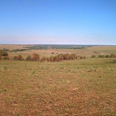
Osage Hills State Park is a state park in Osage County, northeastern Oklahoma, set across rolling hills covered with dense woodland, rocky outcrops, and small streams. The park offers hiking trails, a small lake, camping areas, and stone cabins built into the natural terrain.

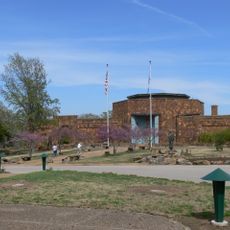
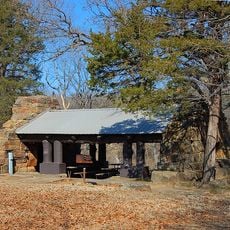
In the 1930s, workers from the Civilian Conservation Corps built the park's stone structures, including cabins and a dining hall, using local materials found on site. This work was part of a national effort to develop public parks during a period of widespread unemployment.

The land was once an Osage settlement area, linking today's visitors to Native American heritage in northeast Oklahoma. The landscape itself tells this story through how people gather and move through the space.

The park is open year-round, though trails can become slippery after rain, so sturdy shoes are a good idea. If you plan to stay overnight in a cabin or at a campsite, booking ahead is recommended since space is limited.

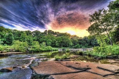
Sand Creek winds through the park and forms small waterfalls along its course, which are easy to spot from the trails nearby. The creek draws anglers throughout the year, as bass, crappie, and catfish can be found in its waters across all seasons.

The community of curious travelers

AroundUs brings together thousands of curated places, local tips, and hidden gems, enriched daily by 60,000 contributors worldwide.

Start exploring
Location
GPS coordinates
36.74170,-96.17970
Latest update
March 3, 2026 08:15
Around this place
Price Tower
United States of America

Price Tower

18.2 km
Tallgrass Prairie Preserve
United States of America

Tallgrass Prairie Preserve

24.1 km
Woolaroc
United States of America

Woolaroc

10.8 km
Kaw Lake
United States of America

Kaw Lake

58.4 km
Fred and Adeline Drummond House
United States of America

Fred and Adeline Drummond House

40.8 km
Dog Iron Ranch
United States of America

Dog Iron Ranch

55.7 km
United States of America

Hulah Lake

22.9 km
LaQuinta
United States of America

LaQuinta

19.9 km
Mullendore Mansion
United States of America

Mullendore Mansion

53.4 km
Bank of Bigheart
United States of America

Bank of Bigheart

20.1 km
Diamond Point School
United States of America

Diamond Point School

42 km
Bank of Hominy
United States of America

Bank of Hominy

41.1 km
Onion Creek Bridge (Coffeyville, Kansas)
United States of America

Onion Creek Bridge (Coffeyville, Kansas)

56.3 km
Old Washington County Courthouse
United States of America

Old Washington County Courthouse

18.6 km
Hominy School
United States of America

Hominy School

41.1 km
Marland Filling Station
United States of America

Marland Filling Station

41 km
Hominy Armory
United States of America

Hominy Armory

41 km
Bethel African Methodist Episcopal Church
United States of America

Bethel African Methodist Episcopal Church

59.6 km
Hominy Osage Round House
United States of America

Hominy Osage Round House

41.1 km
United States of America

Blackburn Methodist Church

55.4 km
City Hall
United States of America

City Hall

16.8 km
Niotaze Methodist Episcopal Church
United States of America

Niotaze Methodist Episcopal Church

39.4 km
Coffeyville Carnegie Public Library Building
United States of America

Coffeyville Carnegie Public Library Building

59.4 km
Little House On The Prairie Museum
United States of America

Little House On The Prairie Museum

52.4 km
Cedar Creek Bridge
United States of America

Cedar Creek Bridge

30.6 km
Osage Casino Hotel - Skiatook
United States of America

Osage Casino Hotel - Skiatook

43 km
Drummond House
United States of America

Drummond House

40.8 km
Osage Hills State Park Picnic Pavilion
United States of America

Osage Hills State Park Picnic Pavilion

925 m
Show the full map
Reviews
Share your experience

No review yet

Discussions
Start a discussion...

No discussion yet

« Osage Hills State Park - State park in Osage County, Oklahoma, US » is provided by Around Us (aroundus.com). Images and texts are derived from Wikimedia project under a Creative Commons license. You are allowed to copy, distribute, and modify copies of this page, under the conditions set by the license, as long as this note is clearly visible.

Discover hidden gems everywhere you go!

From secret cafés to breathtaking viewpoints, skip the crowded tourist spots and find places that match your style. Our app makes it easy with voice search, smart filtering, route optimization, and insider tips from travelers worldwide. Download now for the complete mobile experience.

Around Us App Screenshot

A unique approach to discovering new places

Le Figaro

All the places worth exploring

France Info

A tailor-made excursion in just a few clicks

20 Minutes

Around Us
Travel Guide & Maps
Download

Send to your phone

QR Code
1

Open the camera app on your mobile.

2

Point at the QR code with your camera. A notification will appear.

3

Tap the notification to open the link.