Chest opened
+${chestReward.xp} XP
Explorer
NOUVEAU ×${chestReward.collectible.quantity}
tapez pour fermer
Chest locked

Open chests in the app

Around Us is built for your phone — chests unlock when you walk, explore and capture nearby places.

Enable Location

We need your location to show you interesting places around you

Discover nearby places

Find interesting locations and hidden gems around you

Precise directions

Get accurate directions and distances to places

Your location is never shared with other users. It's only used when you tap the location button.

Black River

Log in to your account

Start exploring — it's free

Trusted by 72,891 travelers worldwide

Continue with Google
Continue with Apple
or

We will send you a code to connect

By continuing, you accept our Terms and Conditions and our Privacy Policy

Check your inbox

We've sent a pincode in your inbox. Please enter the code below.

Black River
Discussion Reviews 1 Photos
14k Popularity

Black River, River system in northern New York, United States

The Black River is a river system in northern New York that flows from North Lake in Herkimer County through multiple counties before reaching Lake Ontario at Dexter. The waterway passes through varied landscapes with different elevations and current speeds along its course.

In the 1800s the Black River Canal was built to connect Rome with Lyons Falls, enabling movement of goods between the Erie Canal and Lake Ontario. This waterway became essential for transporting goods during the region's industrial development.

The Mohawk people established communities along these banks and depended on the river for survival and trade. Their heritage remains an important part of the region's identity.

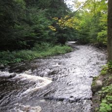
Multiple points along the river allow access for kayaking, fishing, and rafting with good water levels during summer. Visitors should check local conditions beforehand, as current strength varies between sections and safety gear is important.

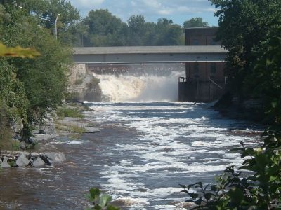
At Lyons Falls the water drops over a 70-foot cascade revealing gneiss cliffs, creating a distinctive geological formation. These falls show exposed rock layers that tell the story of the region's ancient geology.

The community of curious travelers

AroundUs brings together thousands of curated places, local tips, and hidden gems, enriched daily by 60,000 contributors worldwide.

Start exploring
GPS coordinates
43.80775,-75.47200
Latest update
December 7, 2025 20:24
Around this place
Paddock Arcade
United States of America

Paddock Arcade

39.8 km
LeRay Mansion
United States of America

LeRay Mansion

35.7 km
Whetstone Gulf State Park
United States of America

Whetstone Gulf State Park

11.8 km
Public Square
United States of America

Public Square

39.7 km
Roswell P. Flower Memorial Library
United States of America

Roswell P. Flower Memorial Library

39.7 km
Paddock Mansion
United States of America

Paddock Mansion

39.8 km
Watertown Masonic Temple
United States of America

Watertown Masonic Temple

39.8 km
Edmund Wilson House
United States of America

Edmund Wilson House

31.6 km
Gould Mansion Complex
United States of America

Gould Mansion Complex

22.9 km
Emerson Place
United States of America

Emerson Place

39 km
Constable Hall
United States of America

Constable Hall

27.6 km
Franklin B. Hough House
United States of America

Franklin B. Hough House

2.9 km
First Baptist Church and Cook Memorial Building
United States of America

First Baptist Church and Cook Memorial Building

22.3 km
Lewis County Soldiers' and Sailors' Monument
United States of America

Lewis County Soldiers' and Sailors' Monument

2.7 km
Methodist Episcopal Church of West Martinsburg
United States of America

Methodist Episcopal Church of West Martinsburg

6.4 km
State Street Historic District
United States of America

State Street Historic District

21.9 km
Jonathan C. Collins House and Cemetery
United States of America

Jonathan C. Collins House and Cemetery

26.9 km
Otter Lake Community Church
United States of America

Otter Lake Community Church

37.6 km
Osceola Town Hall
United States of America

Osceola Town Hall

39.5 km
Constableville Village Historic District
United States of America

Constableville Village Historic District

27.3 km
Boonville Historic District
United States of America

Boonville Historic District

37.6 km
Lowville Masonic Temple
United States of America

Lowville Masonic Temple

2.9 km
Erwin Library and Pratt House
United States of America

Erwin Library and Pratt House

37.7 km
United States of America

Martinsburg Town Hall

7.9 km
Gen. Walter Martin House
United States of America

Gen. Walter Martin House

7.8 km
Stillwater Mountain Fire Observation Station
United States of America

Stillwater Mountain Fire Observation Station

35.7 km
Dulles State Office Building
United States of America

Dulles State Office Building

39.6 km
Midtown Towers
United States of America

Midtown Towers

39.2 km
Show the full map
Reviews
Share your experience

No review yet

Discussions
Start a discussion...

No discussion yet

« Black River - River system in northern New York, United States » is provided by Around Us (aroundus.com). Images and texts are derived from Wikimedia project under a Creative Commons license. You are allowed to copy, distribute, and modify copies of this page, under the conditions set by the license, as long as this note is clearly visible.

Discover hidden gems everywhere you go!

From secret cafés to breathtaking viewpoints, skip the crowded tourist spots and find places that match your style. Our app makes it easy with voice search, smart filtering, route optimization, and insider tips from travelers worldwide. Download now for the complete mobile experience.

Around Us App Screenshot

A unique approach to discovering new places

Le Figaro

All the places worth exploring

France Info

A tailor-made excursion in just a few clicks

20 Minutes

Around Us
Travel Guide & Maps
Download

Send to your phone

QR Code
1

Open the camera app on your mobile.

2

Point at the QR code with your camera. A notification will appear.

3

Tap the notification to open the link.