Papillion

Log in to your account

AroundUs is a community-driven map of interesting places, built by curious explorers like you. It grows with every review, story, and photo you share.
Connect to save your favorite spots, contribute locations, and create personalized routes.
By continuing, you accept our Terms and Conditions and our Privacy Policy
Add to collection
Map
Suggest a change
Share

Papillion, County seat in Sarpy County, Nebraska, United States.

Papillion is a city in Sarpy County, Nebraska, that serves as the county seat and spans roughly 10 square miles (26 square kilometers). The area features parks and recreational facilities distributed throughout the community.

The city began in 1870 as a railroad settlement along an important line that opened up the region. Its name comes from the French word for butterfly, inspired by the insects that once filled the local creeks.

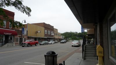
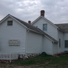
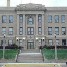
Downtown preserves notable buildings like the old Clarke banking house and the historic courthouse, which shape the character of the place. These structures tell the story of its development as a local administrative and business center over time.

Visiting is possible year-round, with warmer months ideal for exploring parks and outdoor spaces. The place is easy to navigate on foot or by car, with downtown serving as a natural starting point.

The city is home to Werner Park stadium, where the Omaha Storm Chasers, a minor league baseball team, play their home games. This team brings the community together regularly through sporting events and creates a gathering place for residents and visitors.

Location: Sarpy County

Inception: 1870

Elevation above the sea: 308 m

Website: http://papillion.org

GPS coordinates: 41.15583,-96.04083

Latest update: December 6, 2025 22:04

Photos
Around this place
Show the full map
Gerald R. Ford Birthsite and Gardens
United States of America

Gerald R. Ford Birthsite and Gardens

12 km
Fontenelle Forest
United States of America

Fontenelle Forest

10.7 km
Aksarben Village
United States of America

Aksarben Village

9.4 km
Do Space
United States of America

Do Space

11.6 km
South Omaha Veterans Memorial Bridge
United States of America

South Omaha Veterans Memorial Bridge

11.1 km
Boulevards in Omaha, Nebraska
United States of America

Boulevards in Omaha, Nebraska

11.9 km
The Amazing Pizza Machine
United States of America

The Amazing Pizza Machine

9.3 km
Field Club
United States of America

Field Club

11.9 km
Rosewater School
United States of America

Rosewater School

11.7 km
Immaculate Conception Church and School
United States of America

Immaculate Conception Church and School

11.7 km
El Museo Latino
United States of America

El Museo Latino

10 km
Henry Doorly Zoo and Aquarium
United States of America

Henry Doorly Zoo and Aquarium

12.3 km
Vinton Street Commercial Historic District
United States of America

Vinton Street Commercial Historic District

12 km
St. Martin of Tours Episcopal Church
United States of America

St. Martin of Tours Episcopal Church

10.3 km
Hindu Temple of Omaha
United States of America

Hindu Temple of Omaha

11 km
Vinton School
United States of America

Vinton School

11.4 km
Packer's National Bank Building
United States of America

Packer's National Bank Building

9.8 km
Elmwood Tower
United States of America

Elmwood Tower

11.4 km
Robbins School
United States of America

Robbins School

8.8 km
Pipal Park
United States of America

Pipal Park

8.7 km
Eugene C. Eppley Administration Building
United States of America

Eugene C. Eppley Administration Building

11.8 km
Selby Apartments
United States of America

Selby Apartments

12.3 km
John Sautter Farmhouse
United States of America

John Sautter Farmhouse

221 m
Third Sarpy County Courthouse
United States of America

Third Sarpy County Courthouse

323 m
William E. Gordon House
United States of America

William E. Gordon House

11.8 km
Mount Vernon Gardens
United States of America

Mount Vernon Gardens

10.3 km
Omaha Community Playhouse
United States of America

Omaha Community Playhouse

12.2 km
South Omaha Veterans Memorial Bridge
United States of America

South Omaha Veterans Memorial Bridge

11.4 km
Show the full map
Reviews

Visited this place? Tap the stars to rate it and share your experience / photos with the community! Try now! You can cancel it anytime.

« Papillion - County seat in Sarpy County, Nebraska, United States » is provided by Around Us (aroundus.com). Images and texts are derived from Wikimedia project under a Creative Commons license. You are allowed to copy, distribute, and modify copies of this page, under the conditions set by the license, as long as this note is clearly visible.

Discover hidden gems everywhere you go!

From secret cafés to breathtaking viewpoints, skip the crowded tourist spots and find places that match your style. Our app makes it easy with voice search, smart filtering, route optimization, and insider tips from travelers worldwide. Download now for the complete mobile experience.

Around Us App Screenshot

A unique approach to discovering new places

Le Figaro

All the places worth exploring

France Info

A tailor-made excursion in just a few clicks

20 Minutes