Enable Location

We need your location to show you interesting places around you

Discover nearby places

Find interesting locations and hidden gems around you

Precise directions

Get accurate directions and distances to places

Your location is never shared with other users. It's only used when you tap the location button.

Kittery

Log in to your account

Start exploring — it's free

Trusted by 62,061 travelers worldwide

Continue with Google
Continue with Apple
or

We will send you a code to connect

By continuing, you accept our Terms and Conditions and our Privacy Policy

Check your inbox

We've sent a pincode in your inbox. Please enter the code below.

Kittery, Colonial coastal town in York County, Maine, US

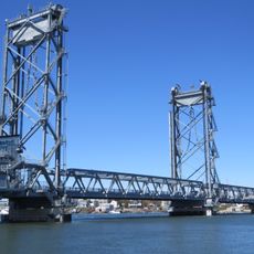
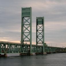
Kittery is a coastal town where the Piscataqua River flows into the Atlantic Ocean, spreading across several islands. Protected harbors here have attracted maritime activity for centuries and remain central to the landscape.

The town began as a settlement in the early 1600s and soon became a center for regional shipbuilding. In 1800, a naval shipyard opened on an island and transformed the local economy.

The community here has deep roots in shipbuilding and maritime work that shape how people think about and use the waterfront. This connection to the sea remains visible in local conversations and in the way residents interact with the river and harbor.

The town sits conveniently off Interstate 95 with easy access to shopping areas and waterfront facilities. Year-round shops and restaurants make it simple for visitors to explore different parts of the area.

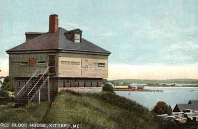
An old fort from the late 1600s built from granite and wood sits on a point overlooking the river entrance and has guarded the area for over 300 years. Visitors can still see different building phases that show how defense methods changed across the centuries.

The community of curious travelers

AroundUs brings together thousands of curated places, local tips, and hidden gems, enriched daily by 60,000 contributors worldwide.

Start exploring
Location
Inception
1632
Elevation above the sea
7 m
GPS coordinates
43.08806,-70.73611
Latest update
December 14, 2025 12:24
Around this place
Portsmouth Naval Prison
United States of America

Portsmouth Naval Prison

1.4 km
Strawbery Banke
United States of America

Strawbery Banke

2.1 km
Sarah Mildred Long Bridge
United States of America

Sarah Mildred Long Bridge

2 km
Memorial Bridge
United States of America

Memorial Bridge

1.6 km
Prescott Park
United States of America

Prescott Park

1.8 km
Moffatt-Ladd House
United States of America

Moffatt-Ladd House

2.2 km
Portsmouth Athenæum
United States of America

Portsmouth Athenæum

2.1 km
Governor John Langdon House
United States of America

Governor John Langdon House

2.2 km
Wentworth-Gardner House
United States of America

Wentworth-Gardner House

1.9 km
Lady Pepperrell House
United States of America

Lady Pepperrell House

1.7 km
MacPheadris-Warner House
United States of America

MacPheadris-Warner House

1.9 km
First Congregational Church and Parsonage
United States of America

First Congregational Church and Parsonage

1.8 km
John Paul Jones Memorial Park
United States of America

John Paul Jones Memorial Park

1.2 km
Mark Wentworth House
United States of America

Mark Wentworth House

2.2 km
Gerrish Warehouse
United States of America

Gerrish Warehouse

1.6 km
Rice Public Library
United States of America

Rice Public Library

564 m
New Hampshire Bank Building
United States of America

New Hampshire Bank Building

2.1 km
General Porter House
United States of America

General Porter House

2.2 km
South Meetinghouse
United States of America

South Meetinghouse

2 km
William Dean Howells House
United States of America

William Dean Howells House

2.1 km
Kittery Community Center
United States of America

Kittery Community Center

1 km
Samuel Badger Monument
United States of America

Samuel Badger Monument

739 m
Mark F. and Eliza J. Wentworth House
United States of America

Mark F. and Eliza J. Wentworth House

607 m
Samuel Beck House
United States of America

Samuel Beck House

2.2 km
Shapley Town House
United States of America

Shapley Town House

1.9 km
Robert and Louisa Traip House
United States of America

Robert and Louisa Traip House

594 m
Portsmouth Parade Historic District
United States of America

Portsmouth Parade Historic District

2.2 km
Sarah Mildred Long Bridge
United States of America

Sarah Mildred Long Bridge

2 km
Show the full map
« Kittery - Colonial coastal town in York County, Maine, US » is provided by Around Us (aroundus.com). Images and texts are derived from Wikimedia project under a Creative Commons license. You are allowed to copy, distribute, and modify copies of this page, under the conditions set by the license, as long as this note is clearly visible.

Discover hidden gems everywhere you go!

From secret cafés to breathtaking viewpoints, skip the crowded tourist spots and find places that match your style. Our app makes it easy with voice search, smart filtering, route optimization, and insider tips from travelers worldwide. Download now for the complete mobile experience.

Around Us App Screenshot

A unique approach to discovering new places

Le Figaro

All the places worth exploring

France Info

A tailor-made excursion in just a few clicks

20 Minutes

Around Us
Travel Guide & Maps
Download

Send to your phone

QR Code
1

Open the camera app on your mobile.

2

Point at the QR code with your camera. A notification will appear.

3

Tap the notification to open the link.