Chest opened
+${chestReward.xp} XP
Explorer
NOUVEAU ×${chestReward.collectible.quantity}
tapez pour fermer
Chest locked

Open chests in the app

Around Us is built for your phone — chests unlock when you walk, explore and capture nearby places.

Enable Location

We need your location to show you interesting places around you

Discover nearby places

Find interesting locations and hidden gems around you

Precise directions

Get accurate directions and distances to places

Your location is never shared with other users. It's only used when you tap the location button.

Browning

Log in to your account

Start exploring — it's free

Trusted by 72,883 travelers worldwide

Continue with Google
Continue with Apple
or

We will send you a code to connect

By continuing, you accept our Terms and Conditions and our Privacy Policy

Check your inbox

We've sent a pincode in your inbox. Please enter the code below.

Discussion Reviews 2 Photos
33.1k Popularity

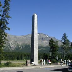
Browning, Tribal headquarters in Montana, United States

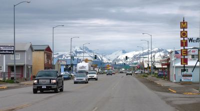
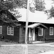
Browning is a town on a high plateau near Glacier National Park, serving as the administrative center of the Blackfeet Indian Reservation. The community includes schools, a community college, public buildings, and lodging options for visitors.

The settlement was founded in 1885 and took its name from the Commissioner of Indian Affairs at that time. It became the administrative seat of the Blackfeet Indian Reservation in 1895.

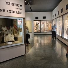
The Museum of the Plains Indian here displays crafts, objects, and art from the Northern Plains nations. You can see how these traditions continue to shape the community today.

The town sits at high elevation and can be cold and windy, especially during winter months. Sturdy shoes and warm clothing help when walking around the area.

In a famous winter night during 1916, temperatures dropped around 55 degrees Celsius in less than 24 hours. This extreme weather event remains part of the area's local history.

The community of curious travelers

AroundUs brings together thousands of curated places, local tips, and hidden gems, enriched daily by 60,000 contributors worldwide.

Start exploring
Location
Elevation above the sea
1,334 m
GPS coordinates
48.55690,-113.01400
Latest update
December 19, 2025 23:55
Around this place
Camp Disappointment
United States of America

Camp Disappointment

19.5 km
Two Medicine Store
United States of America

Two Medicine Store

27.4 km
Summit Mountain
United States of America

Summit Mountain

34.7 km
Cut Bank Ranger Station Historic District
United States of America

Cut Bank Ranger Station Historic District

27.3 km
United States of America

McClintock Peak

34 km
Two Medicine Campground Camptender's Cabin
United States of America

Two Medicine Campground Camptender's Cabin

27.1 km
Swanson Boathouse
United States of America

Swanson Boathouse

27.5 km
United States of America

Eagle Ribs Mountain

34.2 km
East Glacier Ranger Station Historic District
United States of America

East Glacier Ranger Station Historic District

19.7 km
Museum of the Plains Indian
United States of America

Museum of the Plains Indian

654 m
United States of America

Mission Lake

27.7 km
Two Medicine Campground Amphitheater
United States of America

Two Medicine Campground Amphitheater

26.7 km
United States of America

Scenic viewpoint, parking lot

21.1 km
United States of America

Sunset Viewpoint

33.4 km
United States of America

Blackfeet Heritage Center & Art Gallery

461 m
United States of America

Scenic viewpoint, parking lot

21.5 km
United States of America

Scenic viewpoint, parking lot

21.5 km
United States of America

Running Eagle Falls

25.7 km
United States of America

Scenic viewpoint

25.6 km
United States of America

Statue, Work of art

19.8 km
United States of America

Scenic viewpoint

28.7 km
United States of America

Atlantic Falls

32.3 km
United States of America

Appistoki Falls

26.3 km
United States of America

Running Eagle Falls

25.8 km
United States of America

Rockwell Falls

31 km
United States of America

Waterfall

28.3 km
United States of America

Twin Falls

31.8 km
United States of America

Aster falls

28.3 km
Show the full map
Reviews
Share your experience

No review yet

Discussions
Start a discussion...

No discussion yet

« Browning - Tribal headquarters in Montana, United States » is provided by Around Us (aroundus.com). Images and texts are derived from Wikimedia project under a Creative Commons license. You are allowed to copy, distribute, and modify copies of this page, under the conditions set by the license, as long as this note is clearly visible.

Discover hidden gems everywhere you go!

From secret cafés to breathtaking viewpoints, skip the crowded tourist spots and find places that match your style. Our app makes it easy with voice search, smart filtering, route optimization, and insider tips from travelers worldwide. Download now for the complete mobile experience.

Around Us App Screenshot

A unique approach to discovering new places

Le Figaro

All the places worth exploring

France Info

A tailor-made excursion in just a few clicks

20 Minutes

Around Us
Travel Guide & Maps
Download

Send to your phone

QR Code
1

Open the camera app on your mobile.

2

Point at the QR code with your camera. A notification will appear.

3

Tap the notification to open the link.