Chest opened
+${chestReward.xp} XP
Explorer
NOUVEAU ×${chestReward.collectible.quantity}
tapez pour fermer
Chest locked

Open chests in the app

Around Us is built for your phone — chests unlock when you walk, explore and capture nearby places.

Enable Location

We need your location to show you interesting places around you

Discover nearby places

Find interesting locations and hidden gems around you

Precise directions

Get accurate directions and distances to places

Your location is never shared with other users. It's only used when you tap the location button.

Cleveland Hopkins International Airport

Log in to your account

Start exploring — it's free

Trusted by 73,100 travelers worldwide

Continue with Google
Continue with Apple
or

We will send you a code to connect

By continuing, you accept our Terms and Conditions and our Privacy Policy

Check your inbox

We've sent a pincode in your inbox. Please enter the code below.

Discussion Reviews 1 Photos
144k Popularity

Cleveland Hopkins International Airport, International airport in Cleveland, United States

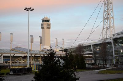
Cleveland Hopkins International Airport is an international airport near Brookpark Road in Ohio that operates three active concourses and covers about 1,717 acres with concrete surfaces and asphalt runways. The facility lies southwest of downtown and connects Cleveland to numerous destinations across North America and beyond.

The site opened as Cleveland Municipal Airport on July 1, 1925, and ranked among the first municipality-owned airports in the United States. In 1930, the operator installed the first control tower with ground-to-air radio system in North America.

The main entrance leads to a terminal building where paintings and sculptures by local artists recall the manufacturing history of the region. Wall reliefs and installations show scenes from industry and transportation that have shaped Northeast Ohio for generations.

The connection to downtown runs through the Red Line rail service, which takes passengers directly to the center of Cleveland in about 30 minutes. Signage in the terminal guides travelers to the station platforms located on the lower level of the facility.

The grounds hosted North America's first control tower in 1930, equipped with a radio system for direct communication between ground staff and aircraft. This technical innovation enabled continuous voice contact throughout approach and departure for the first time.

The community of curious travelers

AroundUs brings together thousands of curated places, local tips, and hidden gems, enriched daily by 60,000 contributors worldwide.

Start exploring
Location
Inception
July 1, 1925
Official opening
July 1, 1925
Reference
CLE
Operator
Cleveland Airport System
Address
Riverside Drive
GPS coordinates
41.41167,-81.84972
Latest update
December 16, 2025 21:59
Around this place
Zero Gravity Research Facility
United States of America

Zero Gravity Research Facility

1.2 km
Puritas Springs Park
United States of America

Puritas Springs Park

3 km
Rocket Engine Test Facility
United States of America

Rocket Engine Test Facility

1.7 km
John and Maria Adams House
United States of America

John and Maria Adams House

5.5 km
Baldwin–Wallace College South Campus Historic District
United States of America

Baldwin–Wallace College South Campus Historic District

4.9 km
Burrell Memorial Observatory
United States of America

Burrell Memorial Observatory

4 km
Old District 10 Schoolhouse
United States of America

Old District 10 Schoolhouse

3.9 km
Baldwin-Wallace College North Campus Historic District
United States of America

Baldwin-Wallace College North Campus Historic District

4.1 km
Buehl House
United States of America

Buehl House

5.1 km
United States of America

Baldwin Lake

5.9 km
The Berea Triangle
United States of America

The Berea Triangle

5.1 km
Frostville Museum
United States of America

Frostville Museum

3.5 km
Berea Union Depot
United States of America

Berea Union Depot

3.4 km
United States of America

Frostville Museum

3.5 km
The Ark
United States of America

The Ark

3.7 km
Harding Memorial Bridge
United States of America

Harding Memorial Bridge

5.7 km
Old District 10 Schoolhouse
United States of America

Old District 10 Schoolhouse

3.9 km
Baldwin University
United States of America

Baldwin University

4.3 km
United States of America

Mastick Woods Golf Course

3.3 km
United States of America

Little Met Golf Course

4.3 km
United States of America

Big Met Golf Course

4 km
United States of America

Springvale Golf Course

5.2 km
United States of America

North Olmsted Golf Club

5.6 km
United States of America

Bottle & Bottega

4.2 km
United States of America

Work of art

2.8 km
United States of America

Berea Falls Scenic Overlook

4 km
United States of America

Scenic viewpoint

3.2 km
United States of America

Scenic viewpoint

2.8 km
Show the full map
Reviews
Share your experience

No review yet

Discussions
Start a discussion...

No discussion yet

« Cleveland Hopkins International Airport - International airport in Cleveland, United States » is provided by Around Us (aroundus.com). Images and texts are derived from Wikimedia project under a Creative Commons license. You are allowed to copy, distribute, and modify copies of this page, under the conditions set by the license, as long as this note is clearly visible.

Discover hidden gems everywhere you go!

From secret cafés to breathtaking viewpoints, skip the crowded tourist spots and find places that match your style. Our app makes it easy with voice search, smart filtering, route optimization, and insider tips from travelers worldwide. Download now for the complete mobile experience.

Around Us App Screenshot

A unique approach to discovering new places

Le Figaro

All the places worth exploring

France Info

A tailor-made excursion in just a few clicks

20 Minutes

Around Us
Travel Guide & Maps
Download

Send to your phone

QR Code
1

Open the camera app on your mobile.

2

Point at the QR code with your camera. A notification will appear.

3

Tap the notification to open the link.