Chest opened
+${chestReward.xp} XP
Explorer
NOUVEAU ×${chestReward.collectible.quantity}
tapez pour fermer
Chest locked

Open chests in the app

Around Us is built for your phone — chests unlock when you walk, explore and capture nearby places.

Enable Location

We need your location to show you interesting places around you

Discover nearby places

Find interesting locations and hidden gems around you

Precise directions

Get accurate directions and distances to places

Your location is never shared with other users. It's only used when you tap the location button.

Co-op City

Log in to your account

Start exploring — it's free

Trusted by 72,879 travelers worldwide

Continue with Google
Continue with Apple
or

We will send you a code to connect

By continuing, you accept our Terms and Conditions and our Privacy Policy

Check your inbox

We've sent a pincode in your inbox. Please enter the code below.

Discussion Reviews 1 Photos
94.7k Popularity

Co-op City, Residential development in Bronx, United States

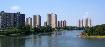
Co-op City is a large housing complex in The Bronx borough of New York City and includes 35 high-rise towers along with seven townhouse clusters on a site of roughly 320 acres containing more than 15,000 residential units. The layout spreads over several streets and forms a nearly self-contained district with its own infrastructure and numerous shared facilities.

The site was originally marshland before the amusement park Freedomland U.S.A. opened here between 1960 and 1964. Work on the current housing development started in 1966 after the park closed.

The streets within the development carry names of well-known figures like archaeologist Cyrus Adler and author Louisa May Alcott. This naming creates a noticeable connection between everyday life here and historical figures from culture and scholarship.

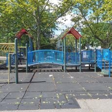
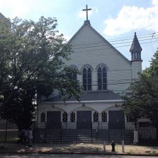
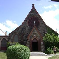
The housing area has eight parking garages along with three shopping centers and provides access within the grounds to educational facilities and various houses of worship. Visitors can find their way around easily since the high-rises and streets are arranged in groups and signage is present at central points.

Residents govern the development through a cooperative structure and elect a 15-member board that sets community rules and organizes operations. This form of self-administration makes the housing area one of the largest cooperatively run developments in the country.

The community of curious travelers

AroundUs brings together thousands of curated places, local tips, and hidden gems, enriched daily by 60,000 contributors worldwide.

Start exploring
Location
Location
Inception
1973
GPS coordinates
40.87389,-73.82944
Latest update
March 5, 2026 21:06
Around this place
Pelham Bay Park
United States of America

Pelham Bay Park

2 km
City Island Bridge
United States of America

City Island Bridge

3.6 km
Bartow-Pell Mansion
United States of America

Bartow-Pell Mansion

2 km
Pelham Bay Bridge
United States of America

Pelham Bay Bridge

1.5 km
Pelham Bridge
United States of America

Pelham Bridge

1.7 km
Pelhamdale
United States of America

Pelhamdale

3.2 km
United Workers Cooperatives
United States of America

United Workers Cooperatives

3.5 km
St. Clare of Assisi's Church
United States of America

St. Clare of Assisi's Church

3.4 km
Huntington Free Library and Reading Room
United States of America

Huntington Free Library and Reading Room

4 km
Bolton Priory
United States of America

Bolton Priory

3.2 km
Magenta Playground
United States of America

Magenta Playground

3.2 km
St. Mary's Church
United States of America

St. Mary's Church

3 km
John Stevens House
United States of America

John Stevens House

3.4 km
Trinity Episcopal Church Complex
United States of America

Trinity Episcopal Church Complex

3.3 km
Manor Club
United States of America

Manor Club

2.9 km
Keeper's House at Williamsbridge Reservoir
United States of America

Keeper's House at Williamsbridge Reservoir

4 km
Lisanti Chapel
United States of America

Lisanti Chapel

2.9 km
Edgewood House
United States of America

Edgewood House

2.4 km
Public School 15
United States of America

Public School 15

1.9 km
Glen Island Park Bath House
United States of America

Glen Island Park Bath House

4 km
Gould family mausoleum
United States of America

Gould family mausoleum

4 km
St. Paul's Church National Historic Site
United States of America

St. Paul's Church National Historic Site

2.2 km
Pelham Parkway-Van Nest Library
United States of America

Pelham Parkway-Van Nest Library

3.6 km
Edenwald Library
United States of America

Edenwald Library

1.9 km
Pelham Bay Library
United States of America

Pelham Bay Library

3.3 km
Westchester Square Library
United States of America

Westchester Square Library

4 km
Morris Park Library
United States of America

Morris Park Library

3.7 km
Wakefield Library
United States of America

Wakefield Library

3.2 km
Show the full map
Reviews
Share your experience

No review yet

Discussions
Start a discussion...

No discussion yet

« Co-op City - Residential development in Bronx, United States » is provided by Around Us (aroundus.com). Images and texts are derived from Wikimedia project under a Creative Commons license. You are allowed to copy, distribute, and modify copies of this page, under the conditions set by the license, as long as this note is clearly visible.

Discover hidden gems everywhere you go!

From secret cafés to breathtaking viewpoints, skip the crowded tourist spots and find places that match your style. Our app makes it easy with voice search, smart filtering, route optimization, and insider tips from travelers worldwide. Download now for the complete mobile experience.

Around Us App Screenshot

A unique approach to discovering new places

Le Figaro

All the places worth exploring

France Info

A tailor-made excursion in just a few clicks

20 Minutes

Around Us
Travel Guide & Maps
Download

Send to your phone

QR Code
1

Open the camera app on your mobile.

2

Point at the QR code with your camera. A notification will appear.

3

Tap the notification to open the link.