Enable Location

We need your location to show you interesting places around you

Discover nearby places

Find interesting locations and hidden gems around you

Precise directions

Get accurate directions and distances to places

Your location is never shared with other users. It's only used when you tap the location button.

Champ Clark Bridge

Log in to your account

Start exploring — it's free

Trusted by 62,173 travelers worldwide

Continue with Google
Continue with Apple
or

We will send you a code to connect

By continuing, you accept our Terms and Conditions and our Privacy Policy

Check your inbox

We've sent a pincode in your inbox. Please enter the code below.

Champ Clark Bridge

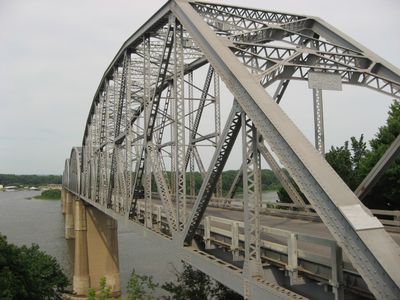
Champ Clark Bridge, Steel truss bridge in Louisiana, United States.

The Champ Clark Bridge is a steel truss bridge carrying U.S. Route 54 across the Mississippi River between Louisiana, Missouri and Pike County, Illinois. The structure uses a latticed steel framework typical of truss designs built in the early 20th century.

The original steel structure opened in 1928 and served the region for nearly a century before a new bridge replaced it in 2019. The transition to modern infrastructure marked the end of the first generation crossing.

The bridge takes its name from James Beauchamp Clark, a Missouri politician who served as Speaker of the House. His name marks this crossing as part of the region's political heritage.

The bridge accommodates regular vehicle traffic on U.S. Route 54 and provides direct passage between the two states. Visitors exploring the region can use this route to connect both sides of the Mississippi.

During construction of the original bridge in 1927, a section collapsed due to faulty temporary supports, resulting in one death and one injury. This accident was a dramatic moment in the structure's building history.

The community of curious travelers

AroundUs brings together thousands of curated places, local tips, and hidden gems, enriched daily by 60,000 contributors worldwide.

Start exploring
Location
Location
Inception
June 1928
Official opening
1928
GPS coordinates
39.45670,-91.04780
Latest update
December 12, 2025 14:24
Around this place
Lock and Dam No. 22
United States of America

Lock and Dam No. 22

26.5 km
Lock and Dam No. 24
United States of America

Lock and Dam No. 24

14.9 km
United States of America

Pike County Courthouse

26.7 km
North Third Street Historic District
United States of America

North Third Street Historic District

327 m
James Beauchamp Clark House
United States of America

James Beauchamp Clark House

17.8 km
Gov. Lloyd Crow Stark House and Carriage House
United States of America

Gov. Lloyd Crow Stark House and Carriage House

1.6 km
John Shastid House
United States of America

John Shastid House

26.7 km
Louisiana Public Library
United States of America

Louisiana Public Library

684 m
Bethel Chapel AME Church
United States of America

Bethel Chapel AME Church

842 m
Georgia Street Historic District
United States of America

Georgia Street Historic District

844 m
Clarksville Historic District
United States of America

Clarksville Historic District

15.7 km
Pittsfield East School
United States of America

Pittsfield East School

26.7 km
St. John's Episcopal Church
United States of America

St. John's Episcopal Church

23.3 km
Pike County Hospital
United States of America

Pike County Hospital

2.2 km
Charles Bacon House
United States of America

Charles Bacon House

976 m
Clifford-Wyrick House
United States of America

Clifford-Wyrick House

15.6 km
Turner-Pharr House
United States of America

Turner-Pharr House

15.5 km
Zoe Theatre
United States of America

Zoe Theatre

26.7 km
Capt. George and Attella Barnard House
United States of America

Capt. George and Attella Barnard House

2.2 km
United States of America

Northern Methodist Episcopal Church of Clarksville

15.9 km
Luce-Dyer House
United States of America

Luce-Dyer House

624 m
Pittsfield Historic District
United States of America

Pittsfield Historic District

26.7 km
Barry Historic District
United States of America

Barry Historic District

26.5 km
Lyman Scott House
United States of America

Lyman Scott House

14.9 km
Goodman–Stark House
United States of America

Goodman–Stark House

366 m
Meloan, Cummins & Co., General Store
United States of America

Meloan, Cummins & Co., General Store

25.1 km
Saverton School
United States of America

Saverton School

27.9 km
Star Theatre
United States of America

Star Theatre

26.4 km
Show the full map
« Champ Clark Bridge - Steel truss bridge in Louisiana, United States » is provided by Around Us (aroundus.com). Images and texts are derived from Wikimedia project under a Creative Commons license. You are allowed to copy, distribute, and modify copies of this page, under the conditions set by the license, as long as this note is clearly visible.

Discover hidden gems everywhere you go!

From secret cafés to breathtaking viewpoints, skip the crowded tourist spots and find places that match your style. Our app makes it easy with voice search, smart filtering, route optimization, and insider tips from travelers worldwide. Download now for the complete mobile experience.

Around Us App Screenshot

A unique approach to discovering new places

Le Figaro

All the places worth exploring

France Info

A tailor-made excursion in just a few clicks

20 Minutes

Around Us
Travel Guide & Maps
Download

Send to your phone

QR Code
1

Open the camera app on your mobile.

2

Point at the QR code with your camera. A notification will appear.

3

Tap the notification to open the link.