Enable Location

We need your location to show you interesting places around you

Discover nearby places

Find interesting locations and hidden gems around you

Precise directions

Get accurate directions and distances to places

Your location is never shared with other users. It's only used when you tap the location button.

Mystic Valley Parkway

Log in to your account

Start exploring — it's free

Trusted by 63,883 travelers worldwide

Continue with Google
Continue with Apple
or

We will send you a code to connect

By continuing, you accept our Terms and Conditions and our Privacy Policy

Check your inbox

We've sent a pincode in your inbox. Please enter the code below.

Discussion Reviews 1 Photos
3.2k Popularity

Mystic Valley Parkway, Historic road in Massachusetts

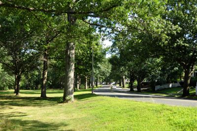
Mystic Valley Parkway is a historic road that runs approximately 13 miles (21 kilometers) through Arlington, Medford, Somerville, and Winchester while following the Mystic River. The route features unpaved or shared-use sections with tree-lined paths and occasional views of the Mystic Lakes, connecting multiple green spaces across the region.

The parkway was designed in the late 1880s by the Olmsted Brothers, a renowned landscape architecture firm that sought to create roads blending function with natural beauty. Part of its route follows the former Middlesex Canal, and it was later listed on the National Register of Historic Places to protect its historical significance.

The parkway takes its name from the Mystic River, a waterway that has shaped the region for centuries and remains central to how locals experience this route. Today, visitors notice how the path brings together people from different towns who come to walk, bike, and spend time in nature together.

The parkway is best explored in good weather and requires comfortable shoes for walking or a bike for cycling, as some sections remain unpaved. Vegetated buffers separate pedestrians and cyclists from road traffic, while recent improvements around the Mystic Lakes have created more off-road sections for safer passage.

The parkway partially follows the historic path of the Middlesex Canal, an 18th-century waterway that served as a key trade route before railroads came to the region. This hidden connection is visible today in how the route subtly traces the geography of early commerce.

The community of curious travelers

AroundUs brings together thousands of curated places, local tips, and hidden gems, enriched daily by 60,000 contributors worldwide.

Start exploring
Location
Location
Location
Location
Architects
Charles Eliot
GPS coordinates
42.42972,-71.13028
Latest update
February 9, 2026 08:23
Around this place
Grandfather's House
United States of America

Grandfather's House

1.8 km
Dilboy Stadium
United States of America

Dilboy Stadium

2 km
Shepherd Brooks Estate
United States of America

Shepherd Brooks Estate

854 m
Unitarian Universalist Church of Medford and the Osgood House
United States of America

Unitarian Universalist Church of Medford and the Osgood House

1.6 km
Medford Pipe Bridge
United States of America

Medford Pipe Bridge

2 km
Isaac Hall House
United States of America

Isaac Hall House

2 km
Mystic Water Works
United States of America

Mystic Water Works

1.6 km
Charles Brooks House
United States of America

Charles Brooks House

1 km
John Wade House
United States of America

John Wade House

1.2 km
Henry Bradlee Jr. House
United States of America

Henry Bradlee Jr. House

1.9 km
Horace Hatch House
United States of America

Horace Hatch House

1.5 km
Jonathan Brooks House
United States of America

Jonathan Brooks House

1 km
Albree-Hall-Lawrence House
United States of America

Albree-Hall-Lawrence House

1 km
Trowbridge-Badger House
United States of America

Trowbridge-Badger House

1.9 km
Deacon John Symmes House
United States of America

Deacon John Symmes House

1.4 km
Jonathan Fletcher House
United States of America

Jonathan Fletcher House

1.1 km
Robert Bacon House
United States of America

Robert Bacon House

1.8 km
Marshall Symmes House
United States of America

Marshall Symmes House

1.5 km
John B. Angier House
United States of America

John B. Angier House

1.7 km
Hillside Avenue Historic District
United States of America

Hillside Avenue Historic District

1.8 km
Albert Ayer House
United States of America

Albert Ayer House

1.5 km
George P. Fernald House
United States of America

George P. Fernald House

1.2 km
Louis N. Maxwell House
United States of America

Louis N. Maxwell House

1.9 km
Maria Bassett House
United States of America

Maria Bassett House

2 km
Thomas Ayer House
United States of America

Thomas Ayer House

1.5 km
Marshall Symmes Tenant House
United States of America

Marshall Symmes Tenant House

1.6 km
Joseph K. Manning House
United States of America

Joseph K. Manning House

2 km
John H. McGill House
United States of America

John H. McGill House

615 m
Show the full map
Reviews
Share your experience

No review yet

Discussions
Start a discussion...

No discussion yet

« Mystic Valley Parkway - Historic road in Massachusetts » is provided by Around Us (aroundus.com). Images and texts are derived from Wikimedia project under a Creative Commons license. You are allowed to copy, distribute, and modify copies of this page, under the conditions set by the license, as long as this note is clearly visible.

Discover hidden gems everywhere you go!

From secret cafés to breathtaking viewpoints, skip the crowded tourist spots and find places that match your style. Our app makes it easy with voice search, smart filtering, route optimization, and insider tips from travelers worldwide. Download now for the complete mobile experience.

Around Us App Screenshot

A unique approach to discovering new places

Le Figaro

All the places worth exploring

France Info

A tailor-made excursion in just a few clicks

20 Minutes

Around Us
Travel Guide & Maps
Download

Send to your phone

QR Code
1

Open the camera app on your mobile.

2

Point at the QR code with your camera. A notification will appear.

3

Tap the notification to open the link.