Chest opened
+${chestReward.xp} XP
Explorer
NOUVEAU ×${chestReward.collectible.quantity}
tapez pour fermer
Chest locked

Open chests in the app

Around Us is built for your phone — chests unlock when you walk, explore and capture nearby places.

Enable Location

We need your location to show you interesting places around you

Discover nearby places

Find interesting locations and hidden gems around you

Precise directions

Get accurate directions and distances to places

Your location is never shared with other users. It's only used when you tap the location button.

Sneads Ferry

Log in to your account

Start exploring — it's free

Trusted by 72,887 travelers worldwide

Continue with Google
Continue with Apple
or

We will send you a code to connect

By continuing, you accept our Terms and Conditions and our Privacy Policy

Check your inbox

We've sent a pincode in your inbox. Please enter the code below.

Discussion Reviews 1 Photos
15.5k Popularity

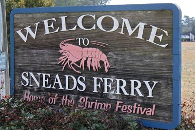
Sneads Ferry, Coastal settlement in Onslow County, North Carolina, United States

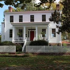
Sneads Ferry is a coastal settlement in Onslow County, North Carolina, stretching along the New River with waterfront neighborhoods. The community includes fishing docks, homes on the water, and public buildings like an education center and library branch.

The settlement began in 1728 when Edmund Ennett established a ferry service across the New River, which was later taken over by Robert Snead. This operation became the foundation for what grew into the present-day community.

The community centers on waterfront living and fishing traditions that shape daily life. You can observe boats coming and going, and locals spending time along the water's edge.

The area is accessible via NC Route 172 and offers basic services like grocery stores and recreation facilities. Keep in mind that proximity to Camp Lejeune may affect traffic and access to certain areas.

The community maintains an active fishing industry that continues to supply seafood to surrounding areas. This working heritage remains visible in the boats, docks, and daily activities throughout the settlement.

The community of curious travelers

AroundUs brings together thousands of curated places, local tips, and hidden gems, enriched daily by 60,000 contributors worldwide.

Start exploring
Location
Elevation above the sea
8 m
GPS coordinates
34.55000,-77.38333
Latest update
December 7, 2025 19:30
Around this place
United States of America

Onslow Beach

10.8 km
Poplar Grove
United States of America

Poplar Grove

43.4 km
Theodore Roosevelt State Natural Area
United States of America

Theodore Roosevelt State Natural Area

53 km
Airlie Gardens
United States of America

Airlie Gardens

55.2 km
Mac Daddy's
United States of America

Mac Daddy's

33 km
United States of America

Museum of the Marine

24.6 km
Yopps Meeting House
United States of America

Yopps Meeting House

2.1 km
Sloop Point
United States of America

Sloop Point

24.7 km
Pelletier House
United States of America

Pelletier House

22.9 km
Foscue Plantation House
United States of America

Foscue Plantation House

55 km
Palo Alto Plantation
United States of America

Palo Alto Plantation

31.9 km
Foscue and Simmons Plantations
United States of America

Foscue and Simmons Plantations

57 km
Eagle Nest
United States of America

Eagle Nest

54.8 km
Mount Lebanon Chapel and Cemetery
United States of America

Mount Lebanon Chapel and Cemetery

55.3 km
Bradley-Latimer Summer House
United States of America

Bradley-Latimer Summer House

55.5 km
Bank of Onslow and Jacksonville Masonic Temple
United States of America

Bank of Onslow and Jacksonville Masonic Temple

22.8 km
Gabriel's Landing
United States of America

Gabriel's Landing

55.1 km
Tinga Nursery
United States of America

Tinga Nursery

56.5 km
Bryan-Bell Farm
United States of America

Bryan-Bell Farm

51.2 km
US Naval Ordnance Testing Facility Observation Tower No. 2
United States of America

US Naval Ordnance Testing Facility Observation Tower No. 2

28.2 km
James D. and Frances Sprunt Cottage
United States of America

James D. and Frances Sprunt Cottage

53.4 km
Bryan Lavender House
United States of America

Bryan Lavender House

53.2 km
Grace Episcopal Church
United States of America

Grace Episcopal Church

57.1 km
Trenton Historic District
United States of America

Trenton Historic District

57.3 km
The Salty Pirate Water Park
United States of America

The Salty Pirate Water Park

32.4 km
Sanderson House
United States of America

Sanderson House

49.3 km
US Naval Ordnance Testing Facility Control Tower
United States of America

US Naval Ordnance Testing Facility Control Tower

30.5 km
Old McFaye's Farm
United States of America

Old McFaye's Farm

54 km
Show the full map
Reviews
Share your experience

No review yet

Discussions
Start a discussion...

No discussion yet

« Sneads Ferry - Coastal settlement in Onslow County, North Carolina, United States » is provided by Around Us (aroundus.com). Images and texts are derived from Wikimedia project under a Creative Commons license. You are allowed to copy, distribute, and modify copies of this page, under the conditions set by the license, as long as this note is clearly visible.

Discover hidden gems everywhere you go!

From secret cafés to breathtaking viewpoints, skip the crowded tourist spots and find places that match your style. Our app makes it easy with voice search, smart filtering, route optimization, and insider tips from travelers worldwide. Download now for the complete mobile experience.

Around Us App Screenshot

A unique approach to discovering new places

Le Figaro

All the places worth exploring

France Info

A tailor-made excursion in just a few clicks

20 Minutes

Around Us
Travel Guide & Maps
Download

Send to your phone

QR Code
1

Open the camera app on your mobile.

2

Point at the QR code with your camera. A notification will appear.

3

Tap the notification to open the link.