Theodore Roosevelt State Natural Area

Log in to your account

AroundUs is a community-driven map of interesting places, built by curious explorers like you. It grows with every review, story, and photo you share.
Connect to save your favorite spots, contribute locations, and create personalized routes.
By continuing, you accept our Terms and Conditions and our Privacy Policy

Theodore Roosevelt State Natural Area

Add to collection
Map
Suggest a change
Share

Theodore Roosevelt State Natural Area, Protected natural area in Carteret County, United States

The Theodore Roosevelt State Natural Area encompasses 265 acres of maritime forest on Bogue Banks, bordered by Bogue Sound and NC 58.

Following Alice Green Hoffman's land ownership in 1917, her niece Eleanor Butler Alexander-Roosevelt inherited the property, which became a state natural area in 1971.

The North Carolina Aquarium at Pine Knoll Shores operates educational programs about local wildlife and conducts ecological research within the protected area.
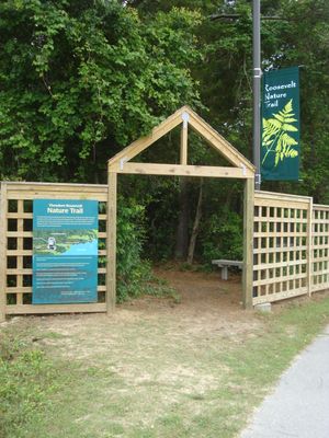
Visitors can access two designated nature trails within the preserve, while the remaining sections stay closed to protect the fragile ecosystem.

The maritime forest contains extensive populations of live oak and loblolly pine trees, providing essential habitats for snowy egrets and ospreys.

Location: Carteret County

Inception: 1971

GPS coordinates: 34.69722,-76.83306

Latest update: March 8, 2025 11:03

Around this place
Show the full map
Fort Macon State Park
United States of America

Fort Macon State Park

13.2 km
Cape Lookout Lighthouse
United States of America

Cape Lookout Lighthouse

29.1 km
Cape Lookout National Seashore
United States of America

Cape Lookout National Seashore

47.3 km
Onslow Beach
United States of America

Onslow Beach

42.3 km
North Carolina Maritime Museum
United States of America

North Carolina Maritime Museum

15.4 km
Neusiok Trail
United States of America

Neusiok Trail

15.8 km
Cape Lookout Village Historic District
United States of America

Cape Lookout Village Historic District

29 km
China Grove
United States of America

China Grove

43.5 km
Cape Lookout Coast Guard Station
United States of America

Cape Lookout Coast Guard Station

29 km
Palo Alto Plantation
United States of America

Palo Alto Plantation

36.7 km
Ocracoke Historic District
United States of America

Ocracoke Historic District

48.5 km
Beaufort Historic District (North Carolina)
United States of America

Beaufort Historic District (North Carolina)

15.4 km
Morehead City Historic District
United States of America

Morehead City Historic District

11.2 km
Jacob Henry House
United States of America

Jacob Henry House

15.3 km
Gibbs House
United States of America

Gibbs House

16 km
Morehead City Municipal Building
United States of America

Morehead City Municipal Building

11.3 km
Mount Shiloh Missionary Baptist Church
United States of America

Mount Shiloh Missionary Baptist Church

46.6 km
Carteret County Home
United States of America

Carteret County Home

17.2 km
Core Sound Waterfowl Museum
United States of America

Core Sound Waterfowl Museum

27.9 km
Cape Lookout Visitor's Center
United States of America

Cape Lookout Visitor's Center

28.1 km
Keepers' Quarters Museum
United States of America

Keepers' Quarters Museum

29.4 km
Beaufort Historic Site
United States of America

Beaufort Historic Site

15.5 km
Havelock Tourist & Event Center
United States of America

Havelock Tourist & Event Center

23.2 km
Harkers Island Visitor Center
United States of America

Harkers Island Visitor Center

28.1 km
History Museum of Carteret County
United States of America

History Museum of Carteret County

11 km
Cape Lookout Lighthouse
United States of America

Cape Lookout Lighthouse

29.4 km
Fort Macon
United States of America

Fort Macon

14 km
Light Station Visitor Center
United States of America

Light Station Visitor Center

29.5 km
Show the full map

Reviews

Visited this place? Tap the stars to rate it and share your experience / photos with the community! Try now! You can cancel it anytime.

« Theodore Roosevelt State Natural Area: Protected natural area in Carteret County, United States » is provided by Around Us (aroundus.com). Images and texts are derived from Wikimedia project under a Creative Commons license. You are allowed to copy, distribute, and modify copies of this page, under the conditions set by the license, as long as this note is clearly visible.

Discover hidden gems everywhere you go!

From secret cafés to breathtaking viewpoints, skip the crowded tourist spots and find places that match your style. Our app makes it easy with voice search, smart filtering, route optimization, and insider tips from travelers worldwide. Download now for the complete mobile experience.

Around Us App Screenshot

A unique approach to discovering new places

Le Figaro

All the places worth exploring

France Info

A tailor-made excursion in just a few clicks

20 Minutes