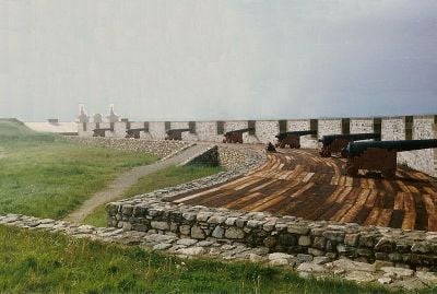
Fort La Baye, French military fort in La Baye, United States.
Fort La Baye was a French military installation that extended along the western bank of the Fox River and provided a strategic position for controlling regional waterways. The post was designed for trade and defense of French interests in this vital river region.
The fort was established in 1717 and served as a French military post until the British took control in 1760 following the Seven Years War. This transition marked the end of French rule in the region.
The place drew French-Canadian families, Native American tribes, and Métis communities who built trading relationships and maintained their networks. These groups met regularly to exchange goods and strengthen their connections.
The remains of the former fort are located at coordinates 44.305°N and 88.0058°W in present-day Green Bay, Wisconsin, where they are easily accessible. Visitors should research the exact location before visiting, as only archaeological traces may be visible at the site.
During the Sauk and Fox War in 1733, the fort witnessed a fierce battle where two sons of French officers were killed. This event left deep scars on the French soldiers and their families.
Location: La Baye
Inception: 1717
Part of: La Baye
GPS coordinates: 44.30500,-88.00580
Latest update: December 13, 2025 17:01
National Railroad Museum
20.1 km
St. Norbert Abbey
17.3 km
Heritage Hill State Historical Park
18.9 km
Cherney Maribel Caves County Park
18.5 km
Tank Cottage
19.1 km
Lost Dauphin Park
13.4 km
Holy Cross Church
21.1 km
Old Nicolet High School
16.5 km
Charles A. Grignon House
18.6 km
North Broadway Street Historic District
17.1 km
Baird Law Office
18.9 km
Free Public Library of Kaukauna
21.3 km
De Pere Lock and Dam Historic District
16.7 km
Cotton House
18.9 km
Albert C. and Ellen H. Neufeld House
19.4 km
C. A. Lawton Company
16.8 km
De Pere Public Library
16.7 km
Otto and Hilda Gretzinger House
17.5 km
Haese Memorial Village Historic District
15.3 km
Norman Brokaw House
20.6 km
Randall Avenue Historic District
17.3 km
Capt. Matthew J. Meade House
20.9 km
Fort Howard Officers' Quarters
18.9 km
Edwin and Jennie Gutknecht House
16.1 km
Mueller-Wright House
12.7 km
Miramar Drive Residential Historic District
19.6 km
Massart Farmstead
18.9 km
Little Kaukauna Lock and Dam
12.3 kmVisited this place? Tap the stars to rate it and share your experience / photos with the community! Try now! You can cancel it anytime.
Discover hidden gems everywhere you go!
From secret cafés to breathtaking viewpoints, skip the crowded tourist spots and find places that match your style. Our app makes it easy with voice search, smart filtering, route optimization, and insider tips from travelers worldwide. Download now for the complete mobile experience.
A unique approach to discovering new places❞
— Le Figaro
All the places worth exploring❞
— France Info
A tailor-made excursion in just a few clicks❞
— 20 Minutes