Enable Location

We need your location to show you interesting places around you

Discover nearby places

Find interesting locations and hidden gems around you

Precise directions

Get accurate directions and distances to places

Your location is never shared with other users. It's only used when you tap the location button.

Cache River National Wildlife Refuge

Log in to your account

Start exploring — it's free

Trusted by 62,061 travelers worldwide

Continue with Google
Continue with Apple
or

We will send you a code to connect

By continuing, you accept our Terms and Conditions and our Privacy Policy

Check your inbox

We've sent a pincode in your inbox. Please enter the code below.

Cache River National Wildlife Refuge

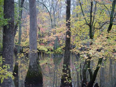
Cache River National Wildlife Refuge, Wildlife refuge and wetland in Arkansas, United States

Cache River National Wildlife Refuge is a large protected area in Arkansas that spans across the floodplain with bottomland forests and lands being restored to their natural state. The terrain includes water channels, mature trees, and open fields that together create habitat for diverse wildlife.

The refuge received protected status in 1986 after local hunters opposed plans to alter the river during the 1970s. Their action preserved the land and helped establish it as a conservation area for future generations.

The refuge takes its name from the river that runs through it and has shaped how people connect with this land. It remains a place where visitors come to observe wildlife and experience the rhythms of a working wetland ecosystem.

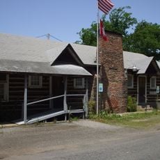
Entry is through a visitor center on Arkansas Highway 33 where you can learn about trails and viewing areas before exploring. It helps to arrive early in the day and check conditions, since water levels can make some routes impassable.

Researchers reported possible sightings in 2005 of a woodpecker species that had been considered lost for decades. This discovery attracted worldwide attention from bird watchers and conservation experts.

The community of curious travelers

AroundUs brings together thousands of curated places, local tips, and hidden gems, enriched daily by 60,000 contributors worldwide.

Start exploring
Location
Inception
1986
GPS coordinates
35.05830,-91.32920
Latest update
December 10, 2025 20:07
Around this place
Bethel House
United States of America

Bethel House

17.7 km
De Valls Bluff Waterworks
United States of America

De Valls Bluff Waterworks

33 km
St. Elizabeth's Catholic Church
United States of America

St. Elizabeth's Catholic Church

32.8 km
First Presbyterian Church
United States of America

First Presbyterian Church

17.8 km
American Legion Hut-Des Arc
United States of America

American Legion Hut-Des Arc

17.6 km
Prairie County Courthouse
United States of America

Prairie County Courthouse

17.5 km
Gregory House
United States of America

Gregory House

25.1 km
Missouri Pacific Railway Caboose No. 928
United States of America

Missouri Pacific Railway Caboose No. 928

35.3 km
Lo Beele House
United States of America

Lo Beele House

22.3 km
Frith-Plunkett House
United States of America

Frith-Plunkett House

18.3 km
Augusta Presbyterian Church
United States of America

Augusta Presbyterian Church

25.6 km
William Black Family House
United States of America

William Black Family House

22.8 km
Cotton Plant Water Tower
United States of America

Cotton Plant Water Tower

9.5 km
Ferguson House
United States of America

Ferguson House

25.5 km
Luke Bone Grocery-Boarding House
United States of America

Luke Bone Grocery-Boarding House

35.4 km
Woodruff County Courthouse
United States of America

Woodruff County Courthouse

25.7 km
Dr. F.W. Buercklin House
United States of America

Dr. F.W. Buercklin House

26.1 km
Mathis-Hyde House
United States of America

Mathis-Hyde House

25.6 km
Bedford Brown Bethell House
United States of America

Bedford Brown Bethell House

17.7 km
Otha Walker Homestead
United States of America

Otha Walker Homestead

30 km
Nimmo Clubhouse
United States of America

Nimmo Clubhouse

19.4 km
J.A. Neaville House
United States of America

J.A. Neaville House

29.6 km
Augusta Commercial Historic District
United States of America

Augusta Commercial Historic District

25.4 km
Moody House
United States of America

Moody House

35.3 km
Prairie County Courthouse
United States of America

Prairie County Courthouse

33 km
Augusta Electrical Generating Plant
United States of America

Augusta Electrical Generating Plant

25.2 km
McCrory Waterworks
United States of America

McCrory Waterworks

25.1 km
Jess Norman Post 166 American Legion Hut
United States of America

Jess Norman Post 166 American Legion Hut

25.1 km
Show the full map
« Cache River National Wildlife Refuge - Wildlife refuge and wetland in Arkansas, United States » is provided by Around Us (aroundus.com). Images and texts are derived from Wikimedia project under a Creative Commons license. You are allowed to copy, distribute, and modify copies of this page, under the conditions set by the license, as long as this note is clearly visible.

Discover hidden gems everywhere you go!

From secret cafés to breathtaking viewpoints, skip the crowded tourist spots and find places that match your style. Our app makes it easy with voice search, smart filtering, route optimization, and insider tips from travelers worldwide. Download now for the complete mobile experience.

Around Us App Screenshot

A unique approach to discovering new places

Le Figaro

All the places worth exploring

France Info

A tailor-made excursion in just a few clicks

20 Minutes

Around Us
Travel Guide & Maps
Download

Send to your phone

QR Code
1

Open the camera app on your mobile.

2

Point at the QR code with your camera. A notification will appear.

3

Tap the notification to open the link.