Enable Location

We need your location to show you interesting places around you

Discover nearby places

Find interesting locations and hidden gems around you

Precise directions

Get accurate directions and distances to places

Your location is never shared with other users. It's only used when you tap the location button.

De Valls Bluff Waterworks

Log in to your account

Start exploring — it's free

Trusted by 62,806 travelers worldwide

Continue with Google
Continue with Apple
or

We will send you a code to connect

By continuing, you accept our Terms and Conditions and our Privacy Policy

Check your inbox

We've sent a pincode in your inbox. Please enter the code below.

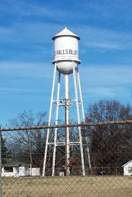
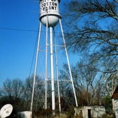
De Valls Bluff Waterworks, Water tower and National Register site in De Valls Bluff, Arkansas.

De Valls Bluff Waterworks is a water supply facility with several structures on a small site. It consists of a steel water tower, an aeration chamber, a pump station, and various support buildings.

The facility was built in 1936 by the Pittsburgh-Des Moines Steel Company as part of the Public Works Administration during the Great Depression. It was later added to the National Register and recognizes the infrastructure investments made during that period.

The facility shows how small towns modernized their water supply during the 1930s. It reflects efforts to provide communities with better services during that era.

The site is located at the intersection of Rumbaugh Street and Hazel Street in the town center. The facility is visible from the street and easy to reach.

The facility was added to the National Register in 2007 through a multiple-property submission. This means several related sites were registered together as a group.

The community of curious travelers

AroundUs brings together thousands of curated places, local tips, and hidden gems, enriched daily by 60,000 contributors worldwide.

Start exploring
Location
Inception
1936
GPS coordinates
34.78278,-91.46306
Latest update
December 14, 2025 18:46
Around this place
Cache River National Wildlife Refuge
United States of America

Cache River National Wildlife Refuge

33 km
Bethel House
United States of America

Bethel House

21.7 km
St. Elizabeth's Catholic Church
United States of America

St. Elizabeth's Catholic Church

343 m
Highway 79 Bridge
United States of America

Highway 79 Bridge

16.9 km
Standard Ice Company Building
United States of America

Standard Ice Company Building

32.8 km
Monroe County Courthouse
United States of America

Monroe County Courthouse

16.9 km
First Presbyterian Church
United States of America

First Presbyterian Church

21.9 km
Bank of Clarendon
United States of America

Bank of Clarendon

16.3 km
American Legion Hut-Des Arc
United States of America

American Legion Hut-Des Arc

21.7 km
Prairie County Courthouse
United States of America

Prairie County Courthouse

21.9 km
Cumberland Presbyterian Church
United States of America

Cumberland Presbyterian Church

16.9 km
Lo Beele House
United States of America

Lo Beele House

27.1 km
Abramson House
United States of America

Abramson House

32.3 km
Frith-Plunkett House
United States of America

Frith-Plunkett House

21.9 km
Arkansas County Courthouse-Northern District
United States of America

Arkansas County Courthouse-Northern District

32.5 km
Bateman-Griffith House
United States of America

Bateman-Griffith House

16.3 km
Moore-Jacobs House
United States of America

Moore-Jacobs House

16.6 km
Lair House
United States of America

Lair House

32.1 km
William Black Family House
United States of America

William Black Family House

27 km
Cotton Plant Water Tower
United States of America

Cotton Plant Water Tower

31.6 km
Jefferies-Crabtree House
United States of America

Jefferies-Crabtree House

16.4 km
Marston House
United States of America

Marston House

16.9 km
Bedford Brown Bethell House
United States of America

Bedford Brown Bethell House

21.6 km
Orth C. Galloway House
United States of America

Orth C. Galloway House

16.5 km
Holly Grove Historic District
United States of America

Holly Grove Historic District

31.8 km
Prairie County Courthouse
United States of America

Prairie County Courthouse

82 m
James A. Walls House
United States of America

James A. Walls House

32.3 km
Stuttgart Commercial Historic District
United States of America

Stuttgart Commercial Historic District

32.8 km
Show the full map
« De Valls Bluff Waterworks - Water tower and National Register site in De Valls Bluff, Arkansas » is provided by Around Us (aroundus.com). Images and texts are derived from Wikimedia project under a Creative Commons license. You are allowed to copy, distribute, and modify copies of this page, under the conditions set by the license, as long as this note is clearly visible.

Discover hidden gems everywhere you go!

From secret cafés to breathtaking viewpoints, skip the crowded tourist spots and find places that match your style. Our app makes it easy with voice search, smart filtering, route optimization, and insider tips from travelers worldwide. Download now for the complete mobile experience.

Around Us App Screenshot

A unique approach to discovering new places

Le Figaro

All the places worth exploring

France Info

A tailor-made excursion in just a few clicks

20 Minutes

Around Us
Travel Guide & Maps
Download

Send to your phone

QR Code
1

Open the camera app on your mobile.

2

Point at the QR code with your camera. A notification will appear.

3

Tap the notification to open the link.