Enable Location

We need your location to show you interesting places around you

Discover nearby places

Find interesting locations and hidden gems around you

Precise directions

Get accurate directions and distances to places

Your location is never shared with other users. It's only used when you tap the location button.

Burnside's Bridge

Log in to your account

Join the adventure

Create your free account and start exploring (like 60k+ others)

We will send you a code to connect

or
Continue with Google
Continue with Apple
By continuing, you accept our Terms and Conditions and our Privacy Policy

Check your inbox

We've sent a pincode in your inbox. Please enter the code below.

Burnside's Bridge

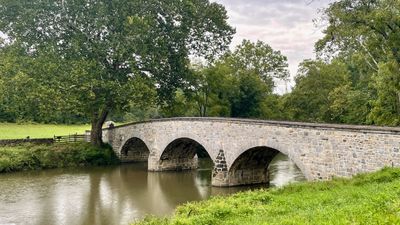
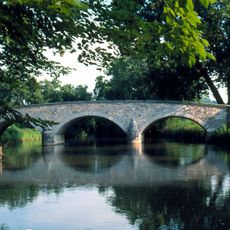
Burnside's Bridge, Stone bridge at Antietam National Battlefield, United States

Description

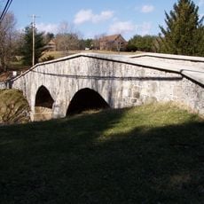
Burnside's Bridge is a stone bridge at the Antietam National Battlefield in Maryland. The structure features three arches that span Antietam Creek over a length of 125 feet, showing thick walls of rough limestone while the roadway surface remains narrow and closed to vehicles today.

History

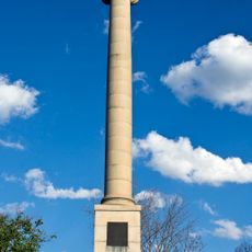
Confederate soldiers defended the crossing during the Battle of Antietam in September 1862 and held back Union troops for several hours. The late capture by Burnside's men influenced the further course of the bloodiest day in the American Civil War.

Culture

The name honors General Ambrose Burnside, whose troops attempted to force the crossing during the battle. Today the site serves as a setting for memorial events and guided tours where park rangers explain the military decisions made that September day.

Practical

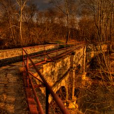
A steep paved path with steps leads down from the upper parking lot to the creek bank. Visitors can walk across the span and view it from both banks of the waterway.

Did you know?

The 1966 restoration returned the appearance to its 1862 state and preserved the original limestone structures. Today you can spot marks from bullet impacts on the stones in some places, left from the battle.

Official opening
1836
GPS coordinates
39.45050,-77.73190
Latest update
December 5, 2025 22:30

AroundUs brings together thousands of curated places, local tips, and hidden gems, enriched daily by 60,000 contributors worldwide. Discover all places nearby (Washington County).

Around this place
Antietam Creek
United States of America

Antietam Creek

3.9 km
James Rumsey Monument
United States of America

James Rumsey Monument

6.1 km
Ram Stadium
United States of America

Ram Stadium

6.6 km
The American Volunteer
United States of America

The American Volunteer

1.2 km
Van Swearingen-Shepherd House
United States of America

Van Swearingen-Shepherd House

6.4 km
Captain William Lucas and Robert Lucas House
United States of America

Captain William Lucas and Robert Lucas House

6.5 km
Antietam National Cemetery
United States of America

Antietam National Cemetery

1.3 km
Antietam Iron Furnace Site and Antietam Village
United States of America

Antietam Iron Furnace Site and Antietam Village

3.9 km
Baltimore & Ohio Railroad Bridge, Antietam Creek
United States of America

Baltimore & Ohio Railroad Bridge, Antietam Creek

6.2 km
Mount Airy
United States of America

Mount Airy

3.1 km
Piper House
United States of America

Piper House

1.5 km
Hoffman Farm
United States of America

Hoffman Farm

5.4 km
Jacob Highbarger House
United States of America

Jacob Highbarger House

1.9 km
Tolson's Chapel and School
United States of America

Tolson's Chapel and School

1.4 km
Sharpsburg Historic District
United States of America

Sharpsburg Historic District

1.7 km
Geeting Farm
United States of America

Geeting Farm

4.2 km
William Chapline House
United States of America

William Chapline House

1.7 km
Hills, Dales and The Vinyard
United States of America

Hills, Dales and The Vinyard

4.2 km
Hitt's Mill and Houses
United States of America

Hitt's Mill and Houses

4.2 km
Keedysville Historic District
United States of America

Keedysville Historic District

4.9 km
Good-Reilly House
United States of America

Good-Reilly House

1.7 km
Joseph C. Hays House
United States of America

Joseph C. Hays House

1.7 km
Antietam National Battlefield Visitor Center
United States of America

Antietam National Battlefield Visitor Center

2.9 km
The Hitt Bridge
United States of America

The Hitt Bridge

4.4 km
Norfolk Southern Potomac River Bridge
United States of America

Norfolk Southern Potomac River Bridge

5.9 km
Potomac River Bridge
United States of America

Potomac River Bridge

6.2 km
C&O Canal Antietam Creek Aqueduct
United States of America

C&O Canal Antietam Creek Aqueduct

3.9 km
Potomac River Bridge
United States of America

Potomac River Bridge

6.2 km
Show the full map
« Burnside's Bridge - Stone bridge at Antietam National Battlefield, United States » is provided by Around Us (aroundus.com). Images and texts are derived from Wikimedia project under a Creative Commons license. You are allowed to copy, distribute, and modify copies of this page, under the conditions set by the license, as long as this note is clearly visible.

Discover hidden gems everywhere you go!

From secret cafés to breathtaking viewpoints, skip the crowded tourist spots and find places that match your style. Our app makes it easy with voice search, smart filtering, route optimization, and insider tips from travelers worldwide. Download now for the complete mobile experience.

Around Us App Screenshot

A unique approach to discovering new places

Le Figaro

All the places worth exploring

France Info

A tailor-made excursion in just a few clicks

20 Minutes

Around Us
Travel Guide & Maps
Download

Send to your phone

QR Code
1

Open the camera app on your mobile.

2

Point at the QR code with your camera. A notification will appear.

3

Tap the notification to open the link.