Enable Location

We need your location to show you interesting places around you

Discover nearby places

Find interesting locations and hidden gems around you

Precise directions

Get accurate directions and distances to places

Your location is never shared with other users. It's only used when you tap the location button.

Baltimore & Ohio Railroad Bridge, Antietam Creek

Log in to your account

Start exploring — it's free

Trusted by 62,419 travelers worldwide

Continue with Google
Continue with Apple
or

We will send you a code to connect

By continuing, you accept our Terms and Conditions and our Privacy Policy

Check your inbox

We've sent a pincode in your inbox. Please enter the code below.

Baltimore & Ohio Railroad Bridge, Antietam Creek

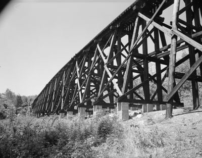
Baltimore & Ohio Railroad Bridge, Antietam Creek, cours d'eau du Maryland, États-Unis

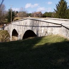
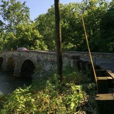
The Baltimore & Ohio Railroad Bridge over Antietam Creek is a railway bridge in Washington County spanning a creek. The structure was built with wood and stone, featuring timber supports and stone abutments, and measures roughly 400 feet in length.

The bridge was built around 1869 and served to connect trains between Hagerstown and Harpers Ferry. It was taken out of service in 1978 after the railroad section it served was abandoned.

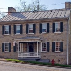
The bridge carries the name of the Baltimore & Ohio Railroad, a company that was vital to the region's development. For local residents, the sight of trains regularly crossing the creek was woven into their daily life and connected their small community to broader markets.

The bridge can be viewed from nearby paths and roads, though direct access is limited. A visit requires no special preparation and suits anyone interested in seeing a historic site.

This is the only timber trestle bridge still standing in Maryland and possibly the only one in the eastern United States. Its survival makes it a rare example of 19th-century railroad construction methods.

The community of curious travelers

AroundUs brings together thousands of curated places, local tips, and hidden gems, enriched daily by 60,000 contributors worldwide.

Start exploring
Inception
1867
GPS coordinates
39.50441,-77.71343
Latest update
February 9, 2026 11:07
Around this place
Burnside's Bridge
United States of America

Burnside's Bridge

6.2 km
South Mountain
United States of America

South Mountain

7.8 km
Washington Monument State Park
United States of America

Washington Monument State Park

7.8 km
Crystal Grottoes
United States of America

Crystal Grottoes

3.2 km
The American Volunteer
United States of America

The American Volunteer

5.6 km
Bowman House
United States of America

Bowman House

5.1 km
Turner's and Fox's Gaps Historic District
United States of America

Turner's and Fox's Gaps Historic District

8.3 km
Antietam National Cemetery
United States of America

Antietam National Cemetery

5.6 km
Cool Hollow House
United States of America

Cool Hollow House

7.5 km
Mount Airy
United States of America

Mount Airy

7.8 km
Piper House
United States of America

Piper House

5.8 km
Hoffman Farm
United States of America

Hoffman Farm

1 km
Washington Monument
United States of America

Washington Monument

7.8 km
Jacob Highbarger House
United States of America

Jacob Highbarger House

6.2 km
Tolson's Chapel and School
United States of America

Tolson's Chapel and School

6.1 km
Boonsboro Historic District
United States of America

Boonsboro Historic District

5.2 km
Sharpsburg Historic District
United States of America

Sharpsburg Historic District

6 km
Geeting Farm
United States of America

Geeting Farm

3.2 km
William Chapline House
United States of America

William Chapline House

5.9 km
Hills, Dales and The Vinyard
United States of America

Hills, Dales and The Vinyard

2.4 km
Hitt's Mill and Houses
United States of America

Hitt's Mill and Houses

2.2 km
Keedysville Historic District
United States of America

Keedysville Historic District

2.3 km
Good-Reilly House
United States of America

Good-Reilly House

5.9 km
Joseph C. Hays House
United States of America

Joseph C. Hays House

6 km
Keedy House
United States of America

Keedy House

4.1 km
Antietam National Battlefield Visitor Center
United States of America

Antietam National Battlefield Visitor Center

4.3 km
The Hitt Bridge
United States of America

The Hitt Bridge

1.8 km
Booth's Mill Bridge
United States of America

Booth's Mill Bridge

3.7 km
Show the full map
« Baltimore & Ohio Railroad Bridge, Antietam Creek - cours d'eau du Maryland, États-Unis » is provided by Around Us (aroundus.com). Images and texts are derived from Wikimedia project under a Creative Commons license. You are allowed to copy, distribute, and modify copies of this page, under the conditions set by the license, as long as this note is clearly visible.

Discover hidden gems everywhere you go!

From secret cafés to breathtaking viewpoints, skip the crowded tourist spots and find places that match your style. Our app makes it easy with voice search, smart filtering, route optimization, and insider tips from travelers worldwide. Download now for the complete mobile experience.

Around Us App Screenshot

A unique approach to discovering new places

Le Figaro

All the places worth exploring

France Info

A tailor-made excursion in just a few clicks

20 Minutes

Around Us
Travel Guide & Maps
Download

Send to your phone

QR Code
1

Open the camera app on your mobile.

2

Point at the QR code with your camera. A notification will appear.

3

Tap the notification to open the link.