Enable Location

We need your location to show you interesting places around you

Discover nearby places

Find interesting locations and hidden gems around you

Precise directions

Get accurate directions and distances to places

Your location is never shared with other users. It's only used when you tap the location button.

South Mountain

Log in to your account

Start exploring — it's free

Trusted by 61,526 travelers worldwide

Continue with Google
Continue with Apple
or

We will send you a code to connect

By continuing, you accept our Terms and Conditions and our Privacy Policy

Check your inbox

We've sent a pincode in your inbox. Please enter the code below.

South Mountain

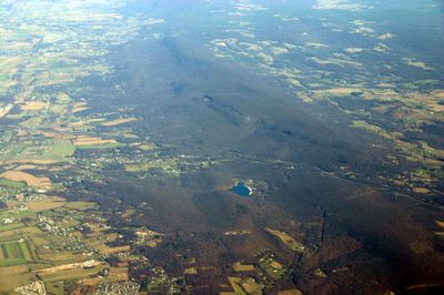
South Mountain, Mountain summit and range in Maryland and Pennsylvania, United States.

Description

South Mountain is a mountain range extending roughly 70 miles from the Potomac River in Maryland to Dillsburg in Pennsylvania, separating two major valleys. The formation features diverse rock types and offers varied terrain with hiking routes, valleys, and several mountain passes that cut through the ridge.

History

In 1862, this range was the site of a major battle during Robert E. Lee's invasion of Maryland in the Civil War. This conflict left marks on the local area and made it a significant battleground of the 1800s.

Culture

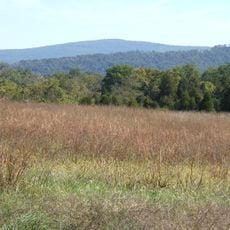
The Appalachian Trail passes through multiple sections of this range, linking hikers to one of North America's most famous long-distance trails. This hiking tradition shapes the region today and draws people seeking to experience a legendary walking route.

Practical

Several passes through the range, including Crampton's Gap and Fox's Gap in Maryland, provide transportation routes between valleys and regions. Visitors should plan their hikes during spring and autumn when weather is mild and visibility across the landscape is best.

Did you know?

The ridge is composed of a blend of granite, gneiss, and limestone, displaying varied rock types and geological features across its structure. Quirauk Mountain, its highest point, offers expansive views across the surrounding landscape from its summit.

Location
Location
Made from material
granite, gneiss, limestone
GPS coordinates
39.50066,-77.62277
Latest update
December 7, 2025 19:26

AroundUs brings together thousands of curated places, local tips, and hidden gems, enriched daily by 60,000 contributors worldwide. Discover all places nearby (Maryland).

Around this place
South Mountain State Park
United States of America

South Mountain State Park

6.3 km
Washington Monument State Park
United States of America

Washington Monument State Park

47 m
Greenbrier State Park
United States of America

Greenbrier State Park

3.9 km
Crystal Grottoes
United States of America

Crystal Grottoes

4.7 km
Lambs Knoll
United States of America

Lambs Knoll

5.8 km
Dahlgren Chapel
United States of America

Dahlgren Chapel

1.8 km
Bowman House
United States of America

Bowman House

3 km
Turner's and Fox's Gaps Historic District
United States of America

Turner's and Fox's Gaps Historic District

1.8 km
Cool Hollow House
United States of America

Cool Hollow House

9.6 km
Baltimore & Ohio Railroad Bridge, Antietam Creek
United States of America

Baltimore & Ohio Railroad Bridge, Antietam Creek

7.8 km
Middletown Historic District
United States of America

Middletown Historic District

9.2 km
Hoffman Farm
United States of America

Hoffman Farm

8.5 km
Peter of P. Grossnickel Farm
United States of America

Peter of P. Grossnickel Farm

10.3 km
Henry Shoemaker Farmhouse
United States of America

Henry Shoemaker Farmhouse

4.4 km
Bowlus Mill House
United States of America

Bowlus Mill House

7.4 km
Washington Monument
United States of America

Washington Monument

47 m
Boonsboro Historic District
United States of America

Boonsboro Historic District

2.6 km
Geeting Farm
United States of America

Geeting Farm

7 km
Routzahn-Miller Farmstead
United States of America

Routzahn-Miller Farmstead

3.2 km
Doub's Mill Historic District
United States of America

Doub's Mill Historic District

9.1 km
Hills, Dales and The Vinyard
United States of America

Hills, Dales and The Vinyard

7.5 km
Hitt's Mill and Houses
United States of America

Hitt's Mill and Houses

7.9 km
Keedysville Historic District
United States of America

Keedysville Historic District

6.7 km
Stonebraker and Harbaugh–Shafer Building
United States of America

Stonebraker and Harbaugh–Shafer Building

9.1 km
Reno Monument
United States of America

Reno Monument

3.4 km
Keedy House
United States of America

Keedy House

7.8 km
The Hitt Bridge
United States of America

The Hitt Bridge

8 km
Booth's Mill Bridge
United States of America

Booth's Mill Bridge

8.5 km
Show the full map
« South Mountain - Mountain summit and range in Maryland and Pennsylvania, United States » is provided by Around Us (aroundus.com). Images and texts are derived from Wikimedia project under a Creative Commons license. You are allowed to copy, distribute, and modify copies of this page, under the conditions set by the license, as long as this note is clearly visible.

Discover hidden gems everywhere you go!

From secret cafés to breathtaking viewpoints, skip the crowded tourist spots and find places that match your style. Our app makes it easy with voice search, smart filtering, route optimization, and insider tips from travelers worldwide. Download now for the complete mobile experience.

Around Us App Screenshot

A unique approach to discovering new places

Le Figaro

All the places worth exploring

France Info

A tailor-made excursion in just a few clicks

20 Minutes

Around Us
Travel Guide & Maps
Download

Send to your phone

QR Code
1

Open the camera app on your mobile.

2

Point at the QR code with your camera. A notification will appear.

3

Tap the notification to open the link.