Enable Location

We need your location to show you interesting places around you

Discover nearby places

Find interesting locations and hidden gems around you

Precise directions

Get accurate directions and distances to places

Your location is never shared with other users. It's only used when you tap the location button.

Falls Lake

Log in to your account

Start exploring — it's free

Trusted by 61,985 travelers worldwide

Continue with Google
Continue with Apple
or

We will send you a code to connect

By continuing, you accept our Terms and Conditions and our Privacy Policy

Check your inbox

We've sent a pincode in your inbox. Please enter the code below.

Falls Lake

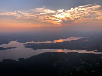
Falls Lake, Reservoir in Durham, Wake, and Granville counties, US

Falls Lake is a reservoir in North Carolina created by damming the Neuse River, surrounded by woodlands with multiple coves and shoreline sections. The water body offers varied access points and environments for different activities throughout its length.

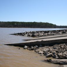
The dam was completed in 1981 by the U.S. Army Corps of Engineers to prevent flooding along the Neuse River. This construction transformed the river landscape and created new conditions for water management and land use in the region.

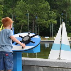
The reservoir serves as a gathering place where locals and visitors spend time fishing, boating, or simply enjoying nature together. The area has become a popular destination for families and outdoor enthusiasts who value water recreation and woodland surroundings.

The area has multiple access points with various facilities including parking, picnic areas, and boat ramps at different shoreline locations. It helps to plan your intended activity beforehand and choose the nearest access point that matches your needs.

The dam flooded what was once called the Falls of the Neuse, a whitewater cascade that gave the water its name. This lost natural feature remains part of the place's identity today.

The community of curious travelers

AroundUs brings together thousands of curated places, local tips, and hidden gems, enriched daily by 60,000 contributors worldwide.

Start exploring
Location
Elevation above the sea
76 m
GPS coordinates
36.01667,-78.71667
Latest update
December 7, 2025 20:22
Around this place
Museum of Life and Science
United States of America

Museum of Life and Science

16.3 km
Stagville
United States of America

Stagville

15.6 km
Frankie's Fun Park
United States of America

Frankie's Fun Park

12.9 km
Falls Lake State Recreation Area
United States of America

Falls Lake State Recreation Area

1.9 km
St. Catherine of Siena Catholic Church
United States of America

St. Catherine of Siena Catholic Church

17.9 km
Horton Grove
United States of America

Horton Grove

16.5 km
Triangle Metro Zoo
United States of America

Triangle Metro Zoo

19.6 km
Wright's Automatic Machinery Company
United States of America

Wright's Automatic Machinery Company

15.3 km
Sterling Cotton Mill
United States of America

Sterling Cotton Mill

25.1 km
Shemuel Kearney House
United States of America

Shemuel Kearney House

22.2 km
James Mangum House
United States of America

James Mangum House

1.7 km
Capehart House
United States of America

Capehart House

15.8 km
Forestville Baptist Church
United States of America

Forestville Baptist Church

18.8 km
Dr. Calvin Jones House
United States of America

Dr. Calvin Jones House

19.2 km
Ephphatha Church
United States of America

Ephphatha Church

16.4 km
Holloway Street District
United States of America

Holloway Street District

15.9 km
Purefoy-Chappell House and Outbuildings
United States of America

Purefoy-Chappell House and Outbuildings

18.9 km
Golden Belt Historic District
United States of America

Golden Belt Historic District

15.8 km
Cozart-Coley House
United States of America

Cozart-Coley House

20 km
Xtreme Park Adventure
United States of America

Xtreme Park Adventure

4.7 km
Aldridge H. Vann House
United States of America

Aldridge H. Vann House

25.4 km
First National Bank Building
United States of America

First National Bank Building

11.7 km
Wheels Fun Park
United States of America

Wheels Fun Park

13.1 km
Durham Cotton Mills Village Historic District
United States of America

Durham Cotton Mills Village Historic District

15.6 km
Cleveland Street District
United States of America

Cleveland Street District

16.2 km
North Durham-Duke Park District
United States of America

North Durham-Duke Park District

16 km
West Durham Historic District
United States of America

West Durham Historic District

14.5 km
Dillard-Gamble Houses
United States of America

Dillard-Gamble Houses

16 km
Show the full map
« Falls Lake - Reservoir in Durham, Wake, and Granville counties, US » is provided by Around Us (aroundus.com). Images and texts are derived from Wikimedia project under a Creative Commons license. You are allowed to copy, distribute, and modify copies of this page, under the conditions set by the license, as long as this note is clearly visible.

Discover hidden gems everywhere you go!

From secret cafés to breathtaking viewpoints, skip the crowded tourist spots and find places that match your style. Our app makes it easy with voice search, smart filtering, route optimization, and insider tips from travelers worldwide. Download now for the complete mobile experience.

Around Us App Screenshot

A unique approach to discovering new places

Le Figaro

All the places worth exploring

France Info

A tailor-made excursion in just a few clicks

20 Minutes

Around Us
Travel Guide & Maps
Download

Send to your phone

QR Code
1

Open the camera app on your mobile.

2

Point at the QR code with your camera. A notification will appear.

3

Tap the notification to open the link.