Falls Lake State Recreation Area

Log in to your account

AroundUs is a community-driven map of interesting places, built by curious explorers like you. It grows with every review, story, and photo you share.
Connect to save your favorite spots, contribute locations, and create personalized routes.
Continue with Google
Continue with Apple
Continue with X
Continue with Facebook
Continue with email
By continuing, you accept our Terms and Conditions and our Privacy Policy
Create an account

Falls Lake State Recreation Area

Add to collection
Map
Suggest a change
Share

Falls Lake State Recreation Area, State park in Durham County, United States.

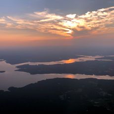
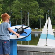
Falls Lake State Recreation Area is a recreation destination along a large reservoir in Durham County, featuring numerous trails and multiple access points for various activities. The area spans around 5,000 acres and provides opportunities for camping, boating, swimming, and mountain biking.

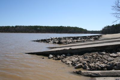
The dam was built from 1978 to 1981 by the US Army Corps of Engineers to control flooding of the Neuse River and protect local communities. This project created the reservoir that forms the centerpiece of the recreation area today.

The area connects to the Mountains-to-Sea Trail, linking hikers to a larger pathway that extends from the Great Smoky Mountains to North Carolina's Outer Banks. This connection shows how the region values outdoor recreation as part of its identity.

The area has seven different entry points with parking and facilities, making it easy to find your preferred activity. Visitors should know that some areas vary by season and it helps to check ahead for the best time to visit for your planned activity.

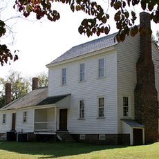
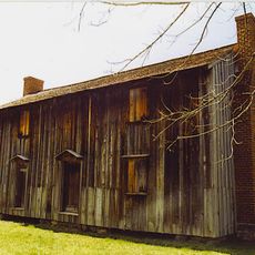
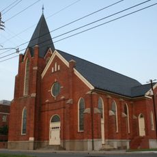
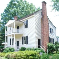
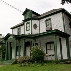
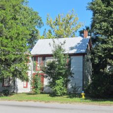
Historic buildings like the James Mangum House and Rock Cliff Farm still stand on the grounds, connecting visitors to the region's farming heritage. These structures show how people once used the land before the reservoir was created.

Location: Durham County

Location: Wake County

Inception: 1981

Website: http://ncparks.gov/falls-lake-state-recreation-area

GPS coordinates: 36.01670,-78.69580

Latest update: December 9, 2025 18:48

Photos
Around this place
Falls Lake
United States of America

Falls Lake

1.9 km
Museum of Life and Science
United States of America

Museum of Life and Science

18.2 km
Stagville
United States of America

Stagville

17 km
Confederate Soldiers Monument
United States of America

Confederate Soldiers Monument

18.5 km
St. Catherine of Siena Catholic Church
United States of America

St. Catherine of Siena Catholic Church

16.1 km
Horton Grove
United States of America

Horton Grove

17.8 km
Triangle Metro Zoo
United States of America

Triangle Metro Zoo

17.7 km
St. Joseph's African Methodist Episcopal Church
United States of America

St. Joseph's African Methodist Episcopal Church

18.5 km
Wright's Automatic Machinery Company
United States of America

Wright's Automatic Machinery Company

17.2 km
James Mangum House
United States of America

James Mangum House

752 m
Capehart House
United States of America

Capehart House

14.3 km
Forestville Baptist Church
United States of America

Forestville Baptist Church

17 km
Dr. Calvin Jones House
United States of America

Dr. Calvin Jones House

17.3 km
Ephphatha Church
United States of America

Ephphatha Church

18.3 km
Somerhill Gallery
United States of America

Somerhill Gallery

18.6 km
Holloway Street District
United States of America

Holloway Street District

17.8 km
Purefoy-Chappell House and Outbuildings
United States of America

Purefoy-Chappell House and Outbuildings

17.1 km
Golden Belt Historic District
United States of America

Golden Belt Historic District

17.6 km
First National Bank Building
United States of America

First National Bank Building

11.4 km
Haleys Branch
United States of America

Haleys Branch

18.3 km
Liberty Warehouse Nos. 1 and 2
United States of America

Liberty Warehouse Nos. 1 and 2

18.5 km
Cleveland Street District
United States of America

Cleveland Street District

18 km
Durham Cotton Mills Village Historic District
United States of America

Durham Cotton Mills Village Historic District

17.4 km
North Durham-Duke Park District
United States of America

North Durham-Duke Park District

17.9 km
West Durham Historic District
United States of America

West Durham Historic District

16.4 km
Erwin Cotton Mills Company Mill No. 1 Headquarters Building
United States of America

Erwin Cotton Mills Company Mill No. 1 Headquarters Building

18 km
Venable Tobacco Company Prizery and Receiving Room
United States of America

Venable Tobacco Company Prizery and Receiving Room

18.5 km
Dillard-Gamble Houses
United States of America

Dillard-Gamble Houses

17.9 km
Show the full map
Reviews

Visited this place? Tap the stars to rate it and share your experience / photos with the community! Try now! You can cancel it anytime.

« Falls Lake State Recreation Area - State park in Durham County, United States » is provided by Around Us (aroundus.com). Images and texts are derived from Wikimedia project under a Creative Commons license. You are allowed to copy, distribute, and modify copies of this page, under the conditions set by the license, as long as this note is clearly visible.

Discover hidden gems everywhere you go!

From secret cafés to breathtaking viewpoints, skip the crowded tourist spots and find places that match your style. Our app makes it easy with voice search, smart filtering, route optimization, and insider tips from travelers worldwide. Download now for the complete mobile experience.

Around Us App Screenshot

A unique approach to discovering new places

Le Figaro

All the places worth exploring

France Info

A tailor-made excursion in just a few clicks

20 Minutes