Enable Location

We need your location to show you interesting places around you

Discover nearby places

Find interesting locations and hidden gems around you

Precise directions

Get accurate directions and distances to places

Your location is never shared with other users. It's only used when you tap the location button.

Acushnet Cedar Swamp

Log in to your account

Start exploring — it's free

Trusted by 62,546 travelers worldwide

Continue with Google
Continue with Apple
or

We will send you a code to connect

By continuing, you accept our Terms and Conditions and our Privacy Policy

Check your inbox

We've sent a pincode in your inbox. Please enter the code below.

Acushnet Cedar Swamp, espace naturel protégé américain

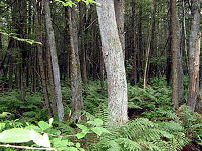
Acushnet Cedar Swamp is a large protected wetland and forest area in Massachusetts covering about 450 hectares. Tall Atlantic White Cedar trees grow here partly submerged in water, creating a dense landscape with moss-covered mounds and thick undergrowth throughout the swamp.

The swamp was designated a National Natural Landmark in 1972 in recognition of its natural importance. The landscape was shaped by glaciers thousands of years ago, and the cedar forests have been part of the local ecosystem for centuries.

The swamp is named after the Atlantic White Cedar trees that have shaped this landscape for centuries. These trees define how the place looks and what people come to experience here.

Access to the swamp is through a small brown gate entrance where a trail leads into the wooded area. The paths can be muddy and wet, especially after rain or snow melt, so wear appropriate footwear and plan your visit for clear weather.

The wood of Atlantic White Cedar trees is fragrant and durable and was historically harvested for roofing shingles, fences, and boats. Today harvesting is restricted to protect the fragile wetlands and rare plants that depend on undisturbed conditions.

The community of curious travelers

AroundUs brings together thousands of curated places, local tips, and hidden gems, enriched daily by 60,000 contributors worldwide.

Start exploring
Location
GPS coordinates
41.69220,-70.95970
Latest update
February 9, 2026 11:07
Around this place
New Bedford Whaling Museum
United States of America

New Bedford Whaling Museum

7 km
New Bedford Whaling National Historical Park
United States of America

New Bedford Whaling National Historical Park

7 km
Seamen's Bethel
United States of America

Seamen's Bethel

7 km
Buttonwood Park Zoo
United States of America

Buttonwood Park Zoo

6.9 km
Nathan and Mary Johnson properties
United States of America

Nathan and Mary Johnson properties

7.1 km
New Bedford Historic District
United States of America

New Bedford Historic District

7 km
New Bedford – Fairhaven Bridge
United States of America

New Bedford – Fairhaven Bridge

6.9 km
Sgt. William H. Carney House
United States of America

Sgt. William H. Carney House

6.5 km
Buttonwood Park Historic District
United States of America

Buttonwood Park Historic District

6.7 km
Fairhaven Bridge Light
United States of America

Fairhaven Bridge Light

6.9 km
Central New Bedford Historic District
United States of America

Central New Bedford Historic District

6.9 km
Acushnet Heights Historic District
United States of America

Acushnet Heights Historic District

5.5 km
United States Customhouse
United States of America

United States Customhouse

7 km
Union Street Railway Carbarn, Repair Shop
United States of America

Union Street Railway Carbarn, Repair Shop

5.1 km
Riverside Cemetery
United States of America

Riverside Cemetery

5.9 km
Union Baptist Church
United States of America

Union Baptist Church

6.8 km
County Street Historic District
United States of America

County Street Historic District

7.1 km
First Baptist Church
United States of America

First Baptist Church

6.8 km
Hixville Village Historic District
United States of America

Hixville Village Historic District

6.1 km
Manomet Mills
United States of America

Manomet Mills

4.3 km
North Bedford Historic District
United States of America

North Bedford Historic District

6.3 km
Old Third District Courthouse
United States of America

Old Third District Courthouse

7 km
Times and Olympia Buildings
United States of America

Times and Olympia Buildings

6.8 km
Whitman Mills
United States of America

Whitman Mills

4.7 km
Dawson Building
United States of America

Dawson Building

5.3 km
Bradford Smith Building
United States of America

Bradford Smith Building

5.2 km
Head of the River Historic District
United States of America

Head of the River Historic District

3.6 km
Zeiterion Theatre
United States of America

Zeiterion Theatre

7.1 km
Show the full map
« Acushnet Cedar Swamp - espace naturel protégé américain » is provided by Around Us (aroundus.com). Images and texts are derived from Wikimedia project under a Creative Commons license. You are allowed to copy, distribute, and modify copies of this page, under the conditions set by the license, as long as this note is clearly visible.

Discover hidden gems everywhere you go!

From secret cafés to breathtaking viewpoints, skip the crowded tourist spots and find places that match your style. Our app makes it easy with voice search, smart filtering, route optimization, and insider tips from travelers worldwide. Download now for the complete mobile experience.

Around Us App Screenshot

A unique approach to discovering new places

Le Figaro

All the places worth exploring

France Info

A tailor-made excursion in just a few clicks

20 Minutes

Around Us
Travel Guide & Maps
Download

Send to your phone

QR Code
1

Open the camera app on your mobile.

2

Point at the QR code with your camera. A notification will appear.

3

Tap the notification to open the link.