·

Enable Location

We need your location to show you interesting places around you

Discover nearby places

Find interesting locations and hidden gems around you

Precise directions

Get accurate directions and distances to places

Your location is never shared with other users. It's only used when you tap the location button.

Adams Mill Covered Bridge

Log in to your account

Start exploring — it's free

Trusted by 62,690 travelers worldwide

Continue with Google
Continue with Apple
or

We will send you a code to connect

By continuing, you accept our Terms and Conditions and our Privacy Policy

Check your inbox

We've sent a pincode in your inbox. Please enter the code below.

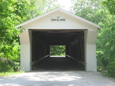
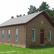
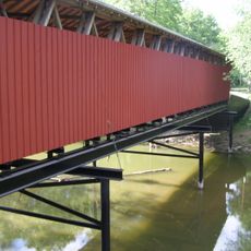
Adams Mill Covered Bridge, Historic covered bridge in Carroll County, Indiana.

Adams Mill Covered Bridge is a wooden structure that spans Wildcat Creek using a Howe truss design reinforced with metal components. The bridge stretches about 144 feet (44 meters) and combines traditional timber framing with metal reinforcement throughout its construction.

The bridge was built in 1872 by the Wheelock Bridge Company of Fort Wayne to serve the Adams Mill settlement area. Around 1900, wooden Burr arches were added to increase its load capacity and blend two different bridge-building techniques into one structure.

The bridge shows construction methods from the 1800s, combining wood and metal in ways that shaped how rural communities built their transportation links.

The bridge has viewing windows cut into its wooden walls so you can see the creek below as you cross. After its major restoration work, the structure has weight restrictions, so plan on walking through at a leisurely pace to enjoy the details.

The bridge combines two different construction methods under one roof - the original 1872 Howe truss was later reinforced with added wooden Burr arches. This unusual pairing lets visitors observe two distinct bridge-building approaches in a single structure.

The community of curious travelers

AroundUs brings together thousands of curated places, local tips, and hidden gems, enriched daily by 60,000 contributors worldwide.

Start exploring
Location
Inception
1872
GPS coordinates
40.48361,-86.51167
Latest update
December 14, 2025 16:46
Around this place
United States of America

Wabash and Erie Canal

18.6 km
Andrew Thomas House
United States of America

Andrew Thomas House

14.1 km
Clinton County Courthouse
United States of America

Clinton County Courthouse

22.5 km
Wilson Bridge
United States of America

Wilson Bridge

15.1 km
Carroll County Courthouse
United States of America

Carroll County Courthouse

17.9 km
Soldiers and Sailors Monument
United States of America

Soldiers and Sailors Monument

17.9 km
Carrollton Bridge
United States of America

Carrollton Bridge

22.1 km
Adams Mill
United States of America

Adams Mill

457 m
Hershey House
United States of America

Hershey House

22 km
Murphy Memorial Drinking Fountain
United States of America

Murphy Memorial Drinking Fountain

17.9 km
Pulaski County Bridge No. 31
United States of America

Pulaski County Bridge No. 31

18.3 km
Delphi Courthouse Square Historic District
United States of America

Delphi Courthouse Square Historic District

17.9 km
Christian Ridge Historic District
United States of America

Christian Ridge Historic District

22.8 km
Foreman-Case House
United States of America

Foreman-Case House

17.7 km
Frankfort Commercial Historic District
United States of America

Frankfort Commercial Historic District

22.5 km
Barnett-Seawright-Wilson House
United States of America

Barnett-Seawright-Wilson House

18 km
Charles H. and Emma Condon House
United States of America

Charles H. and Emma Condon House

23.1 km
Deer Creek Valley Rural Historic District
United States of America

Deer Creek Valley Rural Historic District

15.8 km
South Frankfort Historic District
United States of America

South Frankfort Historic District

23.1 km
Delphi Methodist Episcopal Church
United States of America

Delphi Methodist Episcopal Church

18 km
Niewerth Building
United States of America

Niewerth Building

17.8 km
District School No. 3
United States of America

District School No. 3

19.4 km
John Young House
United States of America

John Young House

7.8 km
Lancaster Covered Bridge
United States of America

Lancaster Covered Bridge

9.1 km
Delphi Public Library
United States of America

Delphi Public Library

17.7 km
O'Connor Bridge
United States of America

O'Connor Bridge

18.6 km
Wildcat Creek Bridge
United States of America

Wildcat Creek Bridge

6.5 km
Gray Bridge
United States of America

Gray Bridge

18.6 km
Show the full map
« Adams Mill Covered Bridge - Historic covered bridge in Carroll County, Indiana » is provided by Around Us (aroundus.com). Images and texts are derived from Wikimedia project under a Creative Commons license. You are allowed to copy, distribute, and modify copies of this page, under the conditions set by the license, as long as this note is clearly visible.

Discover hidden gems everywhere you go!

From secret cafés to breathtaking viewpoints, skip the crowded tourist spots and find places that match your style. Our app makes it easy with voice search, smart filtering, route optimization, and insider tips from travelers worldwide. Download now for the complete mobile experience.

Around Us App Screenshot

A unique approach to discovering new places

Le Figaro

All the places worth exploring

France Info

A tailor-made excursion in just a few clicks

20 Minutes

Around Us
Travel Guide & Maps
Download

Send to your phone

QR Code
1

Open the camera app on your mobile.

2

Point at the QR code with your camera. A notification will appear.

3

Tap the notification to open the link.