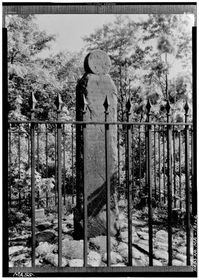
Angle Tree Stone, Colonial boundary marker in North Attleborough, US.
Description
The Angle Tree Stone is a granite boundary marker standing several feet tall with inscriptions carved on its northern and southern faces. The stone records colonial-era survey work through its engraved text and precise placement.
History
Colonial officials from Plymouth and Massachusetts Bay established this border point in 1664, with a stone monument replacing a tree in 1790. This shift reflects the transition from temporary natural markers to permanent stone boundaries.
Culture
The stone reflects early American surveying practices and marks the boundary between Bristol and Norfolk counties in Massachusetts. Visitors can observe how colonial settlers organized land division using physical markers like this one.
Practical
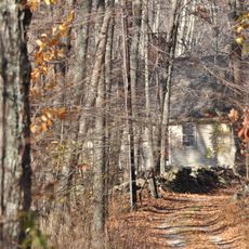
The marker is located on High Street and accessible via a quarter-mile footpath from the main road. Wear sturdy shoes since the dirt path can become muddy after rain or during wet seasons.
Did you know?
A protective brick and plexiglass enclosure has surrounded the stone since 1985, shielding it from ongoing weathering and damage. This shelter allows visitors to view the historic inscriptions while preserving the original surface underneath.
AroundUs brings together thousands of curated places, local tips, and hidden gems, enriched daily by 60,000 contributors worldwide. Discover all places nearby (North Attleborough).
Cumberlandite
7.7 km
Capron Park Zoo
7.7 km
Providence Zen Center
5.7 km
Mount Saint Mary's Abbey
6.6 km
Attleborough Falls Historic District
4.3 km
Arnold Mills Historic District
2.5 km
Lewis Tower House
7.3 km
Ashton Historic District
7.7 km
North Attleborough Town Center Historic District
2.6 km
Woodcock-Hatch-Maxcy House Historic District
3 km
Old Ashton Historic District
7.9 km
Berkeley Mill Village
7.8 km
Blackinton Houses and Park
7.2 km
South Washington Street Historic District
2.7 km
Old Town Historic District
5 km
Attleborough Falls Gasholder Building
3.9 km
The Codding Farm
1.9 km
John Cole Farm
3.5 km
Capron House
6.5 km
Cottage-Freeman Historic District
4.9 km
Commonwealth Avenue Historic District
4.8 km
Herbert A. Sadler House
7 km
Ballou-Weatherhead House
6.6 km
Burlingame-Noon House
7.7 km
Capt. Joel Robinson House
5.9 km
Whipple-Jenckes House
4.3 km
Towne Street Historic District
4.6 km
Luke Jillson House
7.1 kmDiscover hidden gems everywhere you go!
From secret cafés to breathtaking viewpoints, skip the crowded tourist spots and find places that match your style. Our app makes it easy with voice search, smart filtering, route optimization, and insider tips from travelers worldwide. Download now for the complete mobile experience.
A unique approach to discovering new places❞
— Le Figaro
All the places worth exploring❞
— France Info
A tailor-made excursion in just a few clicks❞
— 20 Minutes