Enable Location

We need your location to show you interesting places around you

Discover nearby places

Find interesting locations and hidden gems around you

Precise directions

Get accurate directions and distances to places

Your location is never shared with other users. It's only used when you tap the location button.

Archbald Pothole State Park

Log in to your account

Start exploring — it's free

Trusted by 61,838 travelers worldwide

Continue with Google
Continue with Apple
or

We will send you a code to connect

By continuing, you accept our Terms and Conditions and our Privacy Policy

Check your inbox

We've sent a pincode in your inbox. Please enter the code below.

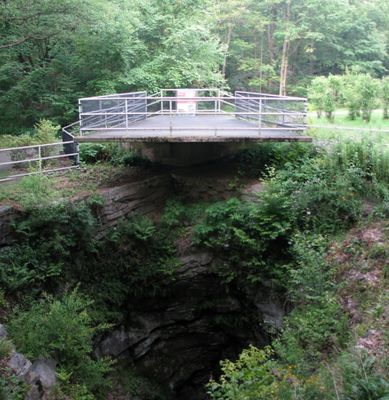
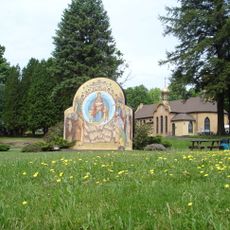
Archbald Pothole State Park, Geological state park in Archbald, Pennsylvania, US.

Description

Archbald Pothole is a natural cylindrical depression carved into bedrock by glacial activity, located within a Pennsylvania state park. The formation displays an elliptical shape and sits as a dramatic hole in the landscape where visitors can observe the raw geological forces that shaped the region.

History

A coal miner named Patrick Mahon stumbled upon this hole in 1884 while expanding a shaft in his mine, when water and stones suddenly rushed into the excavation. The discovery eventually made it a key location for understanding how glacial activity shaped northeastern Pennsylvania.

Culture

The pothole served as a prominent research site for geologists studying glacial formations from the Wisconsin Period, dating back 15,000 years.

Practical

The site is easily accessible during warmer months with marked trails leading directly to the edge of the hole. Visiting between spring and fall offers the best experience, as the park closes during the colder season.

Did you know?

The hole became a major reference for geology studies because it represents one of the finest examples of glacial erosion in North America. Researchers traveled from across the region to examine this natural drill and learn more about the ice age period.

Inception
1964
Operator
Pennsylvania Bureau of State Parks
GPS coordinates
41.51167,-75.57417
Latest update
December 8, 2025 19:58

AroundUs brings together thousands of curated places, local tips, and hidden gems, enriched daily by 60,000 contributors worldwide. Discover all places nearby (Lackawanna County).

Around this place
Nay Aug Park
United States of America

Nay Aug Park

13.5 km
Scranton Cultural Center
United States of America

Scranton Cultural Center

13.3 km
Lackawanna State Park
United States of America

Lackawanna State Park

12.7 km
Everhart Museum
United States of America

Everhart Museum

13.7 km
Lackawanna State Forest
United States of America

Lackawanna State Forest

12.9 km
Scranton City Hall
United States of America

Scranton City Hall

13.5 km
United States of America

Farley's Eatery and Pub

13.6 km
St. Tikhon's Orthodox Monastery
United States of America

St. Tikhon's Orthodox Monastery

14.3 km
St. Peter's Cathedral
United States of America

St. Peter's Cathedral

13.5 km
Scranton
United States of America

Scranton

13.8 km
Lackawanna County Courthouse
United States of America

Lackawanna County Courthouse

13.7 km
William J. Nealon Federal Building and United States Courthouse
United States of America

William J. Nealon Federal Building and United States Courthouse

13.7 km
Albright Memorial Building
United States of America

Albright Memorial Building

13.3 km
North Scranton Junior High School
United States of America

North Scranton Junior High School

11.1 km
Finch Building
United States of America

Finch Building

13.4 km
Tripp Family Homestead
United States of America

Tripp Family Homestead

12.4 km
First Church of Christ, Scientist
United States of America

First Church of Christ, Scientist

13.5 km
Terence V. Powderly House
United States of America

Terence V. Powderly House

13.3 km
Lahey Family Fun Park
United States of America

Lahey Family Fun Park

11 km
Octagon Stone Schoolhouse
United States of America

Octagon Stone Schoolhouse

12 km
Florence Apartments
United States of America

Florence Apartments

13 km
Grand Army of the Republic Building
United States of America

Grand Army of the Republic Building

13.6 km
Carbondale City Hall and Courthouse
United States of America

Carbondale City Hall and Courthouse

8.9 km
James Madison School
United States of America

James Madison School

13.3 km
Dime Bank Building
United States of America

Dime Bank Building

13.8 km
Century Club of Scranton
United States of America

Century Club of Scranton

13 km
Silkman House
United States of America

Silkman House

10.7 km
Waverly Historic District
United States of America

Waverly Historic District

11 km
Show the full map
« Archbald Pothole State Park - Geological state park in Archbald, Pennsylvania, US » is provided by Around Us (aroundus.com). Images and texts are derived from Wikimedia project under a Creative Commons license. You are allowed to copy, distribute, and modify copies of this page, under the conditions set by the license, as long as this note is clearly visible.

Discover hidden gems everywhere you go!

From secret cafés to breathtaking viewpoints, skip the crowded tourist spots and find places that match your style. Our app makes it easy with voice search, smart filtering, route optimization, and insider tips from travelers worldwide. Download now for the complete mobile experience.

Around Us App Screenshot

A unique approach to discovering new places

Le Figaro

All the places worth exploring

France Info

A tailor-made excursion in just a few clicks

20 Minutes

Around Us
Travel Guide & Maps
Download

Send to your phone

QR Code
1

Open the camera app on your mobile.

2

Point at the QR code with your camera. A notification will appear.

3

Tap the notification to open the link.