Enable Location

We need your location to show you interesting places around you

Discover nearby places

Find interesting locations and hidden gems around you

Precise directions

Get accurate directions and distances to places

Your location is never shared with other users. It's only used when you tap the location button.

Aqueduct Bridge

Log in to your account

Start exploring — it's free

Trusted by 65,539 travelers worldwide

Continue with Google
Continue with Apple
or

We will send you a code to connect

By continuing, you accept our Terms and Conditions and our Privacy Policy

Check your inbox

We've sent a pincode in your inbox. Please enter the code below.

Aqueduct Bridge
Discussion Reviews 1 Photos
6.7k Popularity

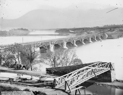
Aqueduct Bridge, Navigable aqueduct in Washington, D.C., US.

The Aqueduct Bridge is a two-level crossing over the Potomac River in Washington, D.C., designed to carry both boat traffic through a water-filled trough on its lower section and road vehicles on top. The trough runs the full length of the bridge, keeping water at a steady level so boats can pass from one side to the other without locks.

The bridge opened in 1843 as part of the Chesapeake and Ohio Canal system, which was built to connect Washington, D.C., with inland regions for trade. When canal traffic declined in the late 1800s, the water trough was converted into a road surface, changing the structure's main purpose entirely.

The bridge sits on the boundary between Washington, D.C., and Virginia, marking one of the oldest crossing points over the Potomac River still in use today. Many locals pass over it daily without realizing they are traveling above a water channel built in the 1800s.

The bridge is open to foot traffic and can be reached from both the Washington, D.C., side and the Virginia side. Walking across during the day gives the clearest view of the two-level layout and how the water channel sits below the road surface.

During the Civil War, the bridge's water troughs were drained and used as storage space by Union Army troops. For a few years, a structure built to carry boats was turned into a supply depot sitting directly above the Potomac River.

The community of curious travelers

AroundUs brings together thousands of curated places, local tips, and hidden gems, enriched daily by 60,000 contributors worldwide.

Start exploring
Location
Official opening
1889
GPS coordinates
38.90420,-77.07060
Latest update
March 3, 2026 10:10
Reviews
Share your experience

No review yet

Discussions
Start a discussion...

No discussion yet

« Aqueduct Bridge - Navigable aqueduct in Washington, D.C., US » is provided by Around Us (aroundus.com). Images and texts are derived from Wikimedia project under a Creative Commons license. You are allowed to copy, distribute, and modify copies of this page, under the conditions set by the license, as long as this note is clearly visible.

Discover hidden gems everywhere you go!

From secret cafés to breathtaking viewpoints, skip the crowded tourist spots and find places that match your style. Our app makes it easy with voice search, smart filtering, route optimization, and insider tips from travelers worldwide. Download now for the complete mobile experience.

Around Us App Screenshot

A unique approach to discovering new places

Le Figaro

All the places worth exploring

France Info

A tailor-made excursion in just a few clicks

20 Minutes

Around Us
Travel Guide & Maps
Download

Send to your phone

QR Code
1

Open the camera app on your mobile.

2

Point at the QR code with your camera. A notification will appear.

3

Tap the notification to open the link.